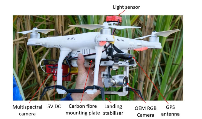
In the last two decades, there was a continuing declining participation rate in STEM education, especially in secondary schools in regional Australia. To reverse this trend and inspire rural school students with science and technology education, both federal and state governments identify the new strategies to promote STEM engagement of school students. In this study, with Queensland government's Engaging Science funding support, Central Queensland University researchers collaborated with rural school to deliver a demonstration with hand-on experiences of drone technologies to students. The activity led students to understand the application of drone technologies in daily life, especially agriculture sector. These activities impressed local communities including both teachers and students by demonstrating real-world problem-solving skills, with increasing over 25% participating students' interest in STEM education. This also leads more future collaboration opportunities to deliver other projects to supporting rural schools' STEM education. Future challenge for conducting these activities would be preparing the activity materials that fit the learning style and time schedule for different knowledge levels of students.
Citation: Yujuan Li, Robert N. Hibbard, Peter L. A. Sercombe, Amanda L. Kelk, Cheng-Yuan Xu. Inspiring and engaging high school students with science and technology education in regional Australia[J]. STEM Education, 2021, 1(2): 114-126. doi: 10.3934/steme.2021009
In the last two decades, there was a continuing declining participation rate in STEM education, especially in secondary schools in regional Australia. To reverse this trend and inspire rural school students with science and technology education, both federal and state governments identify the new strategies to promote STEM engagement of school students. In this study, with Queensland government's Engaging Science funding support, Central Queensland University researchers collaborated with rural school to deliver a demonstration with hand-on experiences of drone technologies to students. The activity led students to understand the application of drone technologies in daily life, especially agriculture sector. These activities impressed local communities including both teachers and students by demonstrating real-world problem-solving skills, with increasing over 25% participating students' interest in STEM education. This also leads more future collaboration opportunities to deliver other projects to supporting rural schools' STEM education. Future challenge for conducting these activities would be preparing the activity materials that fit the learning style and time schedule for different knowledge levels of students.

| [1] | Henriksen, E. K., Introduction: participation in Science, Technology, Engineering and Mathematics (STEM) education: presenting the challenge and introducing projects IRIS in Understanding student participation and choice in science and technology education, E.K. Henriksen, Ed. 2015. doi: 10.1007/978-94-007-7793-4_1 |
| [2] | Kennedy, J., Lyons, T., Quinn, F., The continuing decline of science and mathematics enrolments in Australian high schools. Teaching Science, 2014. 60(2). Retrieved from http://eprints.qut.edu.au/73153/1/Continuing_decline_of_science_proof.pdf. |
| [3] | Timms, M., Moyle, K., Weldon, P., Mitchell., P., Challenges in STEM Learning in Australian Schools: Literature and Policy Review. Australian Council for Educational Research, 2018, Retrieved from Camberwell, Victoria, https://research.acer.edu.au/cgi/viewcontent.cgi?article=1028&context=policy_analysis_misc |
| [4] | Consult Australia, Australia's STEM education challenges: discussion paper. http://www.consultaustralia.com.au/docs/default-source/policy/australia's-stem-education-challenges |
| [5] | National Science Week. https://www.scienceweek.net.au/about/. |
| [6] | Longnecker, N., Elliott, J., Gondwe, M., Inspiring Australia: an evaluation tool for science engagement activities. Report Prepared for the Department of Innovation, Industry, Science, Research and Tertiary Education. 2014, Canberra, Australia. |
| [7] | Office of the Queensland chief scientist. https://www.chiefscientist.qld.gov.au/science-comms/engaging-science-grants. |
| [8] | Integrating drone technology in STEM education: a case study to assess teachers readiness and training needs. Issues in informing science and information technology (2019) 16: p. 61-70. |
| [9] | Queensland Government, Queensland drone strategy. 2018, pp41. https://www.premiers.qld.gov.au/publications/categories/plans/assets/qld-drones-strategy-2018.pdf |
| [10] | Horticulture Innovation Australia, Australian Horticulture Statistics Handbook 2019/20. 2020. https://www.horticulture.com.au/growers/help-your-business-grow/research-reports-publications-fact-sheets-and-more/australian-horticulture-statistics-handbook. |
| [11] | Freeman, B., Consultant Report securing Australia's future STEM. Australian Council of Learned Academies, https://www.acola.org.au. |
| [12] | Thomson, S., De Bortoli, L., Underwood, C., PISA 2015: Reporting Australia's results. ACER. 2017, Retrieved from Camberwell, Victoria, https://research.acer.edu.au/ozpisa/22/. |
| [13] | Thomson, S., Wernert, N., O'Grady, E., Rodrigues, S., TIMSS 2015: Reporting Australia's results. ACER. 2017. Retrieved from Camberwell, Victoria, https://research.acer.edu.au/timss_2015/2/. |
| [14] | Education Council. National STEM school education strategy: a comprehensive plan for Science, Technology, Engineering and Mathematics education in Australia. 2015. http://www.educationcouncil.edu.au/site. |
| [15] | Calculating the vegetation index faster. Remote Sensing of Environment (1990) 34: p. 71-73. |


Figures(7)
Yujuan Li, Robert N. Hibbard, Peter L. A. Sercombe, Amanda L. Kelk, Cheng-Yuan Xu. Inspiring and engaging high school students with science and technology education in regional Australia[J]. STEM Education, 2021, 1(2): 114-126. doi: 10.3934/steme.2021009


 DownLoad: