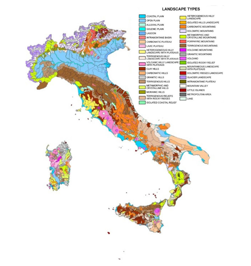
The role of geological and geotematic mapping has recently come to the forefront in spatial/environmental management. This paper aims to present some cases of boundary extension in the use of contemporary cartographic tools (GIS and WEBGIS). The potential of digital maps and associated databases offers a wide range of applications, responding to the urgent need to make available to users (practitioners in the technical sectors, planners and society as a whole) the most important concepts to concretely achieve better land management, active risk prevention and sustainable resource enhancement. The application of geomorphological maps to issues closer to society can effectively create its approach to more properly technical-scientific issues, fostering a shared awareness, useful in protecting and enhancing the fragile Italian territory. The described experiences focus on GIS, which confirms its effectiveness both for social involvement in environmental issues, and in territorial/environmental management.
Citation: Francesca Romana Lugeri, Barbara Aldighieri, Piero Farabollini, Fabrizio Bendia, Alberto Cardillo. Territorial knowledge and cartographic evolution[J]. AIMS Geosciences, 2022, 8(3): 452-466. doi: 10.3934/geosci.2022025
The role of geological and geotematic mapping has recently come to the forefront in spatial/environmental management. This paper aims to present some cases of boundary extension in the use of contemporary cartographic tools (GIS and WEBGIS). The potential of digital maps and associated databases offers a wide range of applications, responding to the urgent need to make available to users (practitioners in the technical sectors, planners and society as a whole) the most important concepts to concretely achieve better land management, active risk prevention and sustainable resource enhancement. The application of geomorphological maps to issues closer to society can effectively create its approach to more properly technical-scientific issues, fostering a shared awareness, useful in protecting and enhancing the fragile Italian territory. The described experiences focus on GIS, which confirms its effectiveness both for social involvement in environmental issues, and in territorial/environmental management.

| [1] | Dent BD, Torguson JS, Hodler TW (2009) Cartography: Thematic Map Design, 6 Eds, New York: McGraw-Hill Higher Education. |
| [2] | Slocum TA, McMaster RB, Kessler FC, et al. (2008) Thematic Cartography and Geovisualization, 3 Eds., Upper Saddle River, NJ: Pearson. |
| [3] | Peterson G (2009) GIS Cartography: A Guide to Effective Map Design. Taylor & Francis. https://doi.org/10.1201/9781003046325 |
| [4] | Harris T, Rouse J, Bergeron S (2010) The Geospatial Semantic Web, Pareto GIS, and the Humanities. In Bodenhamer D, Corrigan J, Harris T, Eds, The Spatial Humanities: GIS and the Future of Humanities Scholarship, Indiana University Press, 124–142. |
| [5] |
Moore A (2015) 'Web Cartography – Map Design for Interactive and Mobile Devices'. J Spat Sci 60: 195–196. https://doi.org/10.1080/14498596.2015.1006113 doi: 10.1080/14498596.2015.1006113

|
| [6] | ISPRA (2022) Carta della Natura. Visualizzatore cartografico. Available from https://sinacloud.isprambiente.it/portal/home/. |
| [7] |
Sieber R (2006) Public Participation Geographic Information Systems: A Literature Review and Framework. Ann Assoc Am Geogr 96: 491–507. https://doi.org/10.1111/j.1467-8306.2006.00702.x doi: 10.1111/j.1467-8306.2006.00702.x
|
| [8] | Haimes P, Baba T, Medley S (2015) Mobile map applications and the democratisation of hazard information. In SIGGRAPH Asia 2015 Mobile Graphics and Interactive Applications. Association for Computing Machinery, New York, NY, USA, Article 7, 1–4. https://doi.org/10.1145/2818427.2818440 |
| [9] | McKinster J, Trautmann N, Barnett M (2013) Teaching Science and Investigating Environmental Issues with Geospatial Technology: Designing Effective Professional Development for Teachers. Springer Science & Business Media: Berlin, Germany, 353. |
| [10] |
Lugeri FR, Farabollini P, Amadio V, et al. (2018) Unconventional Approach for Prevention of Environmental and Related Social Risks: A Geoethic Mission. Geosciences 8: 54. https://doi.org/10.3390/geosciences8020054 doi: 10.3390/geosciences8020054
|
| [11] | Giddens A, Offe C, Touraine (1987) Ecologia politica. Milan: Feltrinelli. |
| [12] |
Lugeri FR, Farabollini P (2018) Discovering the Landscape by Cycling: A Geo-Touristic Experience through Italian Badlands. Geosciences 8: 291. https://doi.org/10.3390/geosciences8080291 doi: 10.3390/geosciences8080291
|
| [13] |
Lugeri FR, Farabollini P, Greco R, et al. (2015) The Geological Characterization of Landscape in Major TV Series: A Suggested Approach to Involve the Public in the Geological Heritage Promotion. Sustainability 7: 4100–4119. https://doi.org/10.3390/su7044100 doi: 10.3390/su7044100
|
| [14] |
Lugeri FR, Farabollini P, Lugeri N (2019) Landscape analysis as a tool for risk reduction. AIMS Geosci 5: 617–630. https://doi.org/10.3934/geosci.2019.3.617 doi: 10.3934/geosci.2019.3.617
|
| [15] | Catton Jr WR, Dunlap RE (1978) Environmental Sociology. A New Paradigm. Am Sociol 13: 41–49. |
| [16] | Forman RTT (1995) Land Mosaics: The Ecology of Landscapes and Regions. Cambridge, UK: Cambridge University Press. https://doi.org/10.1017/9781107050327 |
| [17] | Forman RTT, Godron M (1986) Landscape ecology. New York, USA: John Wiley and Sons. |
| [18] | Naveh Z, Lieberman AS (1994) Landscape Ecology Theory and Application. Series on Environmental Management. Heidelberg, Germany: Springer. |
| [19] | Turner MG, Gardner RH, O'Neill RV (2001) Landscape Ecology in Theory and Practice: Pattern and Process. New York, USA: Springer. |
| [20] |
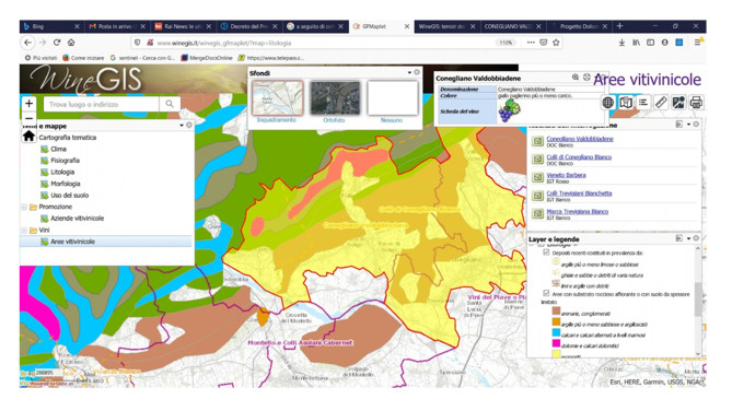
Lugeri FR, Amadio V, Bagnaia R, et al. (2011) Landscapes and Wine Production Areas: A Geomorphological Heritage. Geoheritage 3: 221–232. https://doi.org/10.1007/s12371-011-0035-z doi: 10.1007/s12371-011-0035-z
|
| [21] | Amadio V, Amadei M, Bagnaia R, et al. (2002) The role of geomorphology in landscape ecology: the landscape unit map of Italy, Scale 1: 250,000. In Allison RJ (Ed.), Applied Geomorphology: Theory and Practice, London, UK: Wiley, 265–282. |
| [22] | Amadei M, Bagnaia R, Laureti L, et al. (2004) Carta della natura alla scala 1: 50,000: metodologie di realizzazione. Manuali e linee guida 30/2004. Roma: APAT. |
| [23] | Commission of the European Communities (1991) CORINE Biotopes manual. Vol. 1, 2, 3. EUR. |
| [24] | Cardillo A, Augello R, Canali E, et al. (2021) Carta della Natura della regione Emilia-Romagna: cartografia e valutazione degli habitat alla scala 1: 25.000. Rapporti 354/2021. Roma: ISPRA. |
| [25] |
Troll C (1950) Die geografische Landschaft und ihre Erforschung. Studium Generale, Springer, Heidelberg, 3: 163–181. https://doi.org/10.1007/978-3-662-38240-0_20 doi: 10.1007/978-3-662-38240-0_20
|
| [26] |
Nilsson C, Grelsson G (1995) The fragility of ecosystems: a review. J Appl Ecol 32: 677–692. https://doi.org/10.2307/2404808 doi: 10.2307/2404808
|
| [27] | Rossi PF, Amadio V, Rossi O, et al. (2006) The map of Italian nature: The detection of the hotspots of ecological attention. Technical Report Number 2006–0539. Center for Statistical Ecology and Environmental Statistics, The Pennsylvania State University. |
| [28] | Gregori L (2004) Percorsi geoturistici ed enografici in Umbria. Conference Proceedings of 2 Convegno Geologia & Turismo. Bologna, Italy: Regione Emilia-Romagna, 58–60. |
| [29] | Cita BM, Colacicchi R, Chiesa S, et al. (2004) Italian wines and geology. Coll. Paesaggi Geologici, Milan, Italy: BE-MA editrice. |
| [30] | Globo, CNR-IDPA. WineGIS: terroir dei vini italiani e sistemi informativi geografici. Available from: http://www.winegis.it/it. |
| [31] | ONAV. Perennial guide to Italian wines. Available from: https://www.guidaprosit.it/. |
| [32] | Biraghi F, De Amicis M, Aldighieri B (2019) Geodatabase sulle tipologie di vini e uve in Italia. In: Cristaino D, Gull P, Lazzari M, et al. Eds., GIS Day Calabria 2019-X edizione, 205–212. |
| [33] | Aldighieri B, Testa B (2012) OPENALP- Permanent Naturalistic Alpine Observatory: a way to increase the alpine land value. In Giusti C (Ed.), Geomorphosites 2009. Raising theprofile of geomorphological heritage through iconography, inventory and promotion. Paris-Sorbonne University. Febbraio 2012, 11–16. |
| [34] | Aldighieri B, Di Bona Bonel A, Testa B (2015) Openalp3dolomiti: una piattaforma per la valorizzazione del territorio. In: D'Andrea M, Rossi R (Eds.), Geologia e Turismo 5℃ongresso Nazionale Geologia e Turismo, Bologna, 6–7 giugno 2013. Atti, ISPRA, Roma: 371–378. |
| [35] | Farabollini P, Aringoli D, Bendia F, et al. (2022). The Geo-Itinerary of the 'Anello della Sibilla' between sciences, history and myth: a vehicle for the renaissance of the territories affected by the earthquake. Rendiconti on line della Società Geologica Italiana. Submitted for publication. |
| [36] | ISPRA (2018) Quaderno 13 della Carta Geomorfologica d'Italia 1: 50.000. Servizio Geologico d'Italia, ISPRA Periodici tecnici. I Quaderni, serie III, del SGI. Vol. 13-I. Progetto CARG: modifiche ed integrazioni al Quaderno n. 4/1994/2018. Available from: https://www.isprambiente.gov.it/it/pubblicazioni/periodici-tecnici/i-quaderni-serie-iii-del-sgi/carta-geomorfologica-ditalia-alla-scala-1-50.000-aggiornamento-ed-integrazioni-delle-linee-guida-della-carta-geomorfologica-ditalia-alla-scala-1-50.000-fascicolo-i. |
| [37] | Magnaguagno F (2009) Natura Umana e progetto Versante NORD: un nuovo approccio al disagio giovanile. Atti del Convegno Nazionale "Montagna solidale: i versanti della Montagnaterapia". Campus Selva dei Pini, Università di Roma La Sapienza, Pomezia. Available from: https://www.montagnaterapia.it/convegni.html. |


Figures(6)

Francesca Romana Lugeri, Barbara Aldighieri, Piero Farabollini, Fabrizio Bendia, Alberto Cardillo. Territorial knowledge and cartographic evolution[J]. AIMS Geosciences, 2022, 8(3): 452-466. doi: 10.3934/geosci.2022025


 DownLoad: