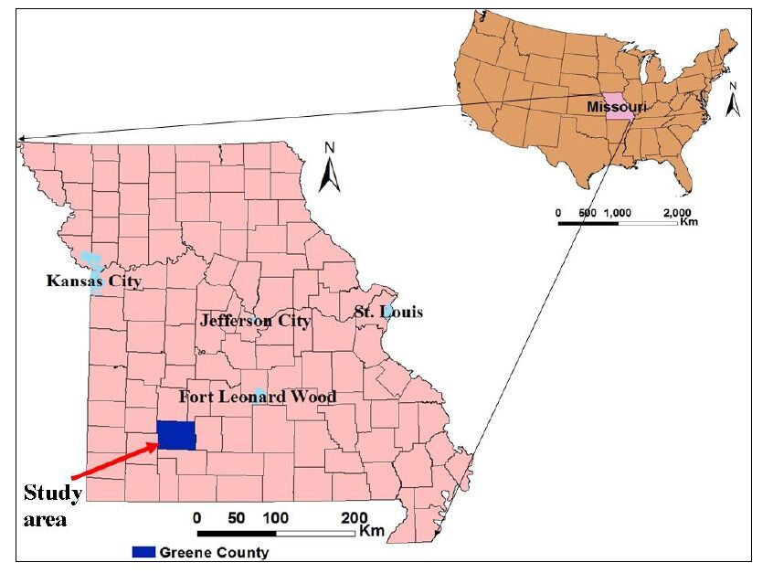
Citation: T.Kidanu Shishay, V.Torgashov Evgeniy, V.Varnavina Aleksandra, L.Anderson Neil. 2016: ERT-based Investigation of a Sinkhole in Greene County, Missouri, AIMS Geosciences, 1(2): 99-115. doi: 10.3934/geosci.2016.2.99
[1] | Shishay Kidanu, Aleksandra Varnavina, Neil Anderson, Evgeniy Torgashov . Pseudo-3D electrical resistivity tomography imaging of subsurface structure of a sinkhole—A case study in Greene County, Missouri. AIMS Geosciences, 2020, 6(1): 54-70. doi: 10.3934/geosci.2020005 |
[2] | Evgeniy V. Torgashov, Aleksandra V. Varnavina . Site Characterization during Bridge Foundation Construction Using Electrical Resistivity Tomography. AIMS Geosciences, 2016, 2(3): 201-213. doi: 10.3934/geosci.2016.3.201 |
[3] | Abdallah Basiru, Shishay T Kidanu, Sergei Rybakov, Nicholas Hasson, Moustapha Kebe, Emmanuel Osei Acheampong . Electrical Resistivity Tomography Investigation of Permafrost Conditions in a Thermokarst Site in Fairbanks, Alaska. AIMS Geosciences, 2024, 10(1): 1-27. doi: 10.3934/geosci.2024001 |
[4] | Stanley C. Nwokebuihe, Abdulrahman M. Alotaibi, Adel Elkrry, Evgeniy V. Torgashov, Neil L. Anderson . Dam Seepage Investigation of an Earthfill Dam in Warren County, Missouri Using Geophysical Methods. AIMS Geosciences, 2017, 3(1): 1-13. doi: 10.3934/geosci.2017.1.1 |
[5] | Paolo Dell'Aversana . Reservoir prescriptive management combining electric resistivity tomography and machine learning. AIMS Geosciences, 2021, 7(2): 138-161. doi: 10.3934/geosci.2021009 |
[6] | Graham L. Gilbert, Arne Instanes, Anatoly O. Sinitsyn, Arne Aalberg . Characterization of two sites for geotechnical testing in permafrost: Longyearbyen, Svalbard. AIMS Geosciences, 2019, 5(4): 868-885. doi: 10.3934/geosci.2019.4.868 |
[7] | Roberto Gianardi, Marina Bisson, Lisa Beccaro, Riccardo De Ritis, Vincenzo Sepe, Laura Colini, Cristiano Tolomei, Luca Cocchi, Claudia Spinetti . High-resolution susceptibility mapping of seismically induced landslides on Ischia island: the 2017 earthquake case study. AIMS Geosciences, 2024, 10(3): 573-597. doi: 10.3934/geosci.2024030 |
[8] | John D Alexopoulos, Nikolaos Voulgaris, Spyridon Dilalos, Georgia S Mitsika, Ioannis-Konstantinos Giannopoulos, Vassileios Gkosios, Nena Galanidou . A geophysical insight of the lithostratigraphic subsurface of Rodafnidia area (Lesbos Isl., Greece). AIMS Geosciences, 2023, 9(4): 769-782. doi: 10.3934/geosci.2023041 |
[9] | Hui-yue Wang, Sha-sha Yu, De-long Huang, Chang-lu Xu, Hang Cen, Qiang Liu, Zhong-ling Zong, Zi-Yuan Huang . Seismic response of utility tunnel systems embedded in a horizontal heterogeneous domain subjected to oblique incident SV-wave. AIMS Geosciences, 2025, 11(1): 47-67. doi: 10.3934/geosci.2025004 |
[10] | Mike Long, Jean Sebastien L’Heureux, Bjørn Kristian Fiskvik Bache, Alf Kristian Lund, Svein Hove, Karl Gunnar Sødal, Helene Alexandra Amundsen, Steinar Nordal, Alberto Montafia . Site characterisation and some examples from large scale testing at the Klett quick clay research site. AIMS Geosciences, 2019, 5(3): 344-389. doi: 10.3934/geosci.2019.3.344 |
Greene County, Missouri, is part of the Ozarks physiographic region and is known for its karst terrain. Karst terrain forms in carbonate and evaporitic rocks, primarily by dissolution and is typically characterized by numerous sinkholes, losing streams (swallow holes), springs, caves, and other related features. Because of this, karst areas are one of the most challenging environments in terms of groundwater, engineering and environmental issues [1]. Sinkholes are one of the most common karst structures in the world [2] and constitute a major hazard in karst areas [3,4].
Greene County Missouri is known for the presence of karstic features such as caves, springs and, more importantly, sinkholes [5]. It is reported that more than 2500 sinkholes and 245 caves have been identified in Greene County (Greene County Comprehensive Plan, page 52,2007). As stated by Carbonel et al. in [6], catastrophic collapsing sinkholes may lead to injury, fatalities and cause significant damage to infrastructure. For example, the sinkhole that occurred in Nixa, Missouri, on August 13,2006, swallowed a car, the garage it was parked in, and part of the adjoining house [7].
Geology, hydrology, and anthropogenic factors have an impact on the formation of sinkholes [7,8,9]. Hence, an understanding of the interaction between these factors assists in determining where andhow a sinkhole may form. Moreover, the investigation of the formation mechanism and sinkhole morphology allows for design of applicable mitigation measures. Investigation of existing sinkholes is necessary from an engineering standpoint to locate and characterize the source of water, seepage/piping pathways, voids (if present) and variable depth to top of rock. As stated by Gutiérrez in [10], effective sinkhole investigation should integrate a variety of investigative approaches that include geological, geophysical, and geomorphological analysis. The author’s perspective is that any sinkhole can be mitigated using appropriate engineering technologies if the flow of piping water is effectively cut-off.
Geological analysis and geophysical methods can assist in characterizing sinkhole morphology, evolution and formation mechanisms, while geomorphological methods assist in the understanding of recent sinkhole activity and human influences [2]. Geophysical methods are often particularly useful as there is usually a good contrast between the physical properties of the sinkhole fill, which consists of either water, air, or soil, and the surrounding less disturbed strata. Geophysical methods that are commonly used for sinkhole investigation include seismic reflection and refraction [11], gravimetry [12], ground-penetrating radar [13,14], electrical resistivity tomography [15,16,17,18], and multichannel analysis of surface waves [19,20].
Electrical resistivity tomography (ERT) is routinely used in Missouri to image the shallow subsurface in karst terrain because undisturbed soil, carbonate rock, clay in-fill, and air-filled cavities are generally characterized by very high resistivity contrasts [5]. Multichannel analysis of surface waves (MASW) is also often a very appropriate method for sinkhole investigation, because variations in shear-wave velocity can be used to differentiate between various types of unconsolidated soils and bedrock [21].
In this research ERT and MASW techniques were employed together with a confirmatory boring to effectively characterize the subsurface morphology of an active sinkhole, hereafter referred to as Sinkhole_1. Moreover, historical maps were analyzed to reveal the evolution of the karst feature and land use changes. Analyses suggest the sinkhole developed along a natural north-south surface drainage pathway. Furthermore, the subsurface structure of the sinkhole depicts a vertical zone of moisture flow and associated soil piping. From the nature of the overburden material and the characteristics of the sinkhole, it is concluded that the sinkhole is predominantly a cover subsidence sinkhole (gradual subsidence) based on the sinkhole classification system described by Waltham et al. in [22]. Historical photographs suggest that cover collapse could have occurred in an area slightly to the north of the current active sinkhole.
Sinkhole_1, is located in Greene County, Missouri (Figure 1). The geology of Greene County comprises thick Mississippian-age limestones and cherty limestones underlain by Ordovician and Cambrian-aged strata (Table 1). Greene County lies on the western side of the Ozark Uplift and the rock layers regionally dip gently towards the west with minor faulting and folding.
System | Series | Group | Formation | Thickness (ft) | |
Mississipian | Osagean | Burlington-Keokuk Formation | 150-270 | ||
Elsey Formation | 25-75 | ||||
Reeds-Spring Formation | 125 | ||||
Pierson Formation | 90 | ||||
Kinkerhookian | Chouteau | Northview Formation | 5-80 | ||
Compton Formation | 30 | ||||
Ordovician | Canadian | Cotter Formation | 600 | ||
Jefferson-City Formation | |||||
Ruobidoux Formation | 150 | ||||
Gasconade Formation | Upper Gasconade Dolomite | 350 | |||
Lower Gasconade Dolomite | |||||
Gunter Sandstone Member | 25 | ||||
Cambrian | Upper | Eminence Formation | 500 | ||
Potasi Formation | |||||
Elvins | Derby-Doerun Formation | ||||
Davis Formation | 150 | ||||
Bonneterre Formation | 200 | ||||
Lamotte Formation | 150 | ||||
Precambrian | Crystalline rock |
The Mississippian age Burlington-Keokuk Limestone is the dominant bedrock exposed in the study area (Figure 2). In this bedrock, layers of limestone are interbedded with thin layers of chert and the presence of chert nodules within limestone layers.
The Burlington-Keokuk Formation is up to 270ft (82.3m) thick [23] but varies in thickness from place to place due to erosion. The limestone is a light gray, coarsely crystalline, and nearly pure calcite which is highly susceptible to solution. Uneven dissolution of this formation has resulted in highly irregular bedrock-overburden interface [24]. This limestone bedrock is mainly characterized by the formation of prominent knobs (pinnacles) of bedrock bounded by deep troughs (grikes) caused by dissolution in pre-existing fractures. The thickness of residuum is highly variable, in many areas stream erosion has removed the residuum and rock is at or very near to the surface, whereas in other areas it reaches to a thickness of about 40ft (12.2m) [25].
The limestone bedrock in Greene County was subjected to tectonic forces and has undergone some structural deformations during the Ouachita Orogeny. Orndorff in [26] has mentioned that the geological structures formed from this deformation appear to have controlled the development of karst. Generally, the faults in the study area are oriented northwest and northeast [27]. Joints are common structural features, similar to faults, where lateral and vertical displacements have not occurred. McCracken in [27], states that the bedrock in the study area is characterized by two nearly orthogonal joint sets that exhibit general strike orientations: N 20 ° W, and N 60 ° E and with vertical dipping.
Karst features are prevalent almost throughout Greene County. The Burlington-Keokuk Limestone has been extensively affected by solution process resulting in the formation of numerous karst features: caves, springs, sinkholes, losing streams, cherty clay residuum, etc. As stated by Ismail and Anderson in [5], the sinkholes are formed when carbonic acid from atmospheric carbon dioxide, present in rainwater, percolates downwards into the subsurface and dissolves carbonate bedrock, enlarging fractures and joints into cavities that in most cases were in-filled with piped fine-grained soil as they developed, resulting in gradual subsidence at the surface.
An aerial photograph from 1960 and a series of historical google earth images (Figure 3) were analyzed to reveal the evolution of Sinkhole_1, anthropogenic factors and land use changes. The 1960 aerial photo on the top left of figure 3 shows a north-south elongated feature which is a row of trees along a natural north-south surface drainage pathway in the middle of a farmer’s field. To the north of the row of trees, there is a small surface depression. This suggests that Sinkhole_1 developed at this location originally as a result of the localized ponding of surface water immediately to the north of the zone of dense vegetation. The ponded water and piped fine-grained sediment percolated into the subsurface through the soil and underlying pervasively fractured limestone. The piping of soil lead to surface subsidence and the enlargement of the sinkhole over time.
The second image, a Google Earth® image from March 1997, shows a well-defined circular depression, immediately west of the row of trees imaged in the 1960 photograph. The circular depression is the surface expression of the Sinkhole_1 in 1997. The sinkhole appears to have migrated to the west as a result of the broadening of the surface expression of the original area of subsidence. The observation that the zone subsidence is covered by vegetation and not characterized by scarp features indicates Sinkhole_1 is predominantly a cover subsidence type of sinkhole. The Google Earth® image from April 2003, shows a small surface depression to the north of the main circular depression. The steep angle and the lack of vegetation/grass cover on the scarp in the collapse feature suggest that this collapse may have occurred relatively abruptly. It is possible that this depression is a localized cover collapse feature. Cover collapse is a typical feature of sinkhole development in cohesive soils where the covering sediments contain significant amount of clay. The sediments spall into a cavity and as spalling continues, the cohesive covering sediments form a structural arch and eventually the cavity breaches the ground surface, resulting in sudden and dramatic collapse usually with steep angle scarps.
The series of historical images indicate that Sinkhole_1 is not an instantaneous collapse type of sinkhole; rather it appears to have developed gradually and evolved over time. Sinkhole_1 is therefore classified as cover subsidence. It appears to have initiated about the time the 1960 photograph was taken.
One borehole (BH1) was drilled to facilitate the correlation of the ERT profiles to the actual subsurface geology. The drilling was advanced to the bedrock surface using 8.5 inch (21.6cm) O.D. hollow-stem augers and bedrock was cored using HQ core barrels.
The borehole (BH1) was drilled along ERT profile T13 and ties at 97.5m mark on the profile (Figure 5 and 6a). It was drilled to a depth of 30m below ground surface. The first 2m comprises red clay residuum with chert, with brown silty loam with chert from 0 - 1.1m; 1.1m - 1.8m comprises red silty high plasticity clay, and finally 1.8m - 2m reveals low plasticity clay. Underlying the residual soil is Burlington-Keokuk Limestone, characterized, in core specimens, by numerous horizontal fractures. The rock quality was found to be fair to excellent.
The decomposition of the beds of limestone and chert formed a highly ferruginous deposit of clay mixed with broken and decomposed chert. The broken and decomposed chert gives more porosity to the residual clay soil. Furthermore, the high iron content of the ferruginous clay residuum causes flocculation and form blocky aggregates resulting in increased porosity of the soil. Therefore, as a result of the presence of chert fragments and the flocculated clay structure, the residuum clay soil has higher permeability than expected from a more uniform clay soil. From the borehole samples it is evident that the clay content increases with depth, and this supports the idea that there is piping of fine grained soils.
Multichannel analysis of surface waves (MASW) data were acquired in proximity to Sinkhole_1 and along west-east oriented ERT profiles (Figures 4 and 5). A 24 channel geophone array connected to a seismograph is used to record the seismic data. As presented in Figure 5, six MASW profiles (MASW1, MASW2, MASW3, MASW4, MASW5 and MASW6) were generated and used to verify and constrain the interpretation of the ERT profiles. The NEHRP (National Earthquake Hazard Reduction Program) site classification chart for different geological material, as published in 2000 by the International Building code, provides a basis for the classification of subsurface materials based on their shear wave velocity values. Based on this chart and the borehole control, the shear wave velocity of soil is generally less than 1200feet/sec (366m/sec). An example dispersion curve and corresponding 1-D shear wave velocity profile from MASW5 is presented as Figure 4.
Sixteen west-east oriented 2D electrical resistivity tomography (ERT) profiles were taken at the site with the intent of imaging and characterizing the shallow subsurface in the vicinity of Sinkhole_1. The ERT profiles were acquired along sixteen west-east oriented traverses spaced at 6.1m (20ft) intervals. The traverses are labeled T1, T2, T3, to T16 (Figure 5). Each 2D-ERT profile extends to a maximum depth of 36.5m (120ft). The west-east direction was selected as it is nearly perpendicular to major joints and regional geological structures in the study area, which have a general approximately north-south orientation. ERT data were acquired using an AGI R-8 Supersting multi-channel and multi-electrode resistivity system with 168 electrodes spaced at 1.52m (5ft) intervals and using a dipole-dipole electrode array.
The borehole control and MASW interpretations were superposed on the respective ERT profiles to help verify the interpretations of the electrical resistivity images. Based on the borehole data (BH1) (Figure 6a), the top of weathered rock corresponds approximately to the 125 ohm-m resistivity contour interval on ERT profile T13. Therefore, the resistivity contour value of 125 ohm-m is interpreted as the top of weathered rock on all of the other ERT profiles. Further, BH1 overlain (superposed on T13; Figure 6a) indicates that the zone of relatively low electrical resistivity (Zone A) is not a soil/water filled cavity, but rather fractured and weathered rock with fair to good quality. Therefore, the relatively low resistivity values (less than 125 ohm-m) are attributed to the presence of moisture and/or clay filled fractures. Hence, Zone A is interpreted as a moist fractured rock with some clay infilling fractures. MASW5 ties ERT T13 at 61m mark (Figure 6). The “resistivity” top of weathered rock at the MASW5 location is estimated to be 20ft (6.1m). The 1-D shear wave velocity profile in MASW5 (Figure 6b) shows an abrupt increase of velocity from 1300ft/sec (396m/sec) to 1650ft/sec (503m/sec) at a depth of 20.5ft (6.2m). This increase presumably marks the boundary between dense residual soil and the top of weathered rock and is interpreted as the “acoustic” top of rock. The additional acquired MASW data also correlate with ERT profiles, in terms of estimated depths to top of rock. Figure 7a shows MASW1 tied to the ERT profile T1 at 183m mark; the “resistivity” and “acoustic” top of weathered rock are 2.4m and 2.1m respectively. In Figure 7b, Zone B has very low electrical resistivity (less than 125 ohm-m), but its average shear wave velocity in MASW4 is about 1800ft/sec (549m/s). Similarly, the low resistivity zone (Zone C) in Figure 7c, is characterized by a shear wave velocity ranging from 1450ft/sec (442m/sec) to 1800ft/sec (549m/sec). These values of shear wave velocity are consistent with that of fractured rock. Moreover, strata with comparable resistivity values and similar geological conditions encountered in the borehole was fractured rock (Figure 6a). Hence the most plausible interpretations of zones B and C is that they are zones of fractured rock probably with moist clay infill.
Based on control available, the following interpretational guidelines were established: moist soils are characterized by resistivity values of less than 125 ohm-m; dry soils by resistivity values greater than 125 ohm-m; moist weathered and/or fractured rock by resistivity values less than 600 ohm-m; moist fractured rock with moist piped clay/soil-fill by resistivity values less than 125 ohm-m; and drier, possibly less weathered rock by resistivity values greater than 600 ohm-m. Large air filled cavities should be characterized by very high resistivity values, but dependent on the conductivity of the surrounding material and depth/size/shape of the void. The ERT data acquired at this study indicated that the active sinkhole is not underlain by any substantive air-filled cavities. Four ERT profiles crossing the sinkhole (T7, T8, T9, and T10), with interpreted depths to moist weathered rock and depths to drier, possibly less weathered rock, are shown as Figure 8.
A linear, north-south oriented zone of relatively low resistivity that extends through Sinkhole_1 is readily identified on Figure 9. This linear feature (labeled as joint set 1 in Figure 9) could be a zone of more intense fracturing (i.e. north-south trending joint set). Alternatively, in as much as the zone underlies a natural north-south trending surface drainage pathway, this zone of low resistivity could simply be the result of moisture with piped fines percolating into the subsurface over an extended period of time presumably with some attendant solution-widening.
In addition to the prominent north-south oriented linear feature (joint set 1), other roughly linear trends of low resistivity anomalies with different orientations are also observed in Figure 9. These anomalies are not visually prominent enough and also not well defined linear features to be interpreted as joint sets. However, their general linear trend gives an insight into the possibility of presence of other joint sets or lineaments.
The interpreted 2D-resistivity profiles (T7, T8, and T9) together with information from the borehole log were used to generate geological models depicting the subsurface structure of Sinkhole_1 (Figure 10.T7, T8 and T9). Sinkholes develop as a result of interrelated processes, including bedrock dissolution, rock collapse, soil down-washing/piping and soil collapse. Any one or more of these processes may lead to the development of a sinkhole. The bedrock structure underneath the surface expression of Sinkhole_1 (Figure 10) does not show any sign of major rock collapse. In all the three images (Figure 10), there are zones interpreted as moist, intensely weathered rock with clay fill at various depths beneath and in proximity to the surface expression of Sinkhole_1. This implies that the major process involved in the development of the sinkhole is downward piping of fine-grained sediments, which fill existing and/or developing fractures. As mentioned in previously, the clay residuum has chert fragments and is not as cohesive as it would be expected from a more uniform clay soil. Hence, it is concluded that the sinkhole development involved predominantly a cover subsidence processes, possibly with minor localized cover collapse. From the subsurface structure and surface expression of the sinkhole, plus the nature of the overburden material, Sinkhole_1 is classified as predominantly a cover subsidence sinkhole.
Two-dimensional electrical resistivity profiles were acquired across and in proximity to a sinkhole in Greene County, Missouri. The acquired 2-D resistivity data were processed as 2-D resistivity profiles and the interpretation was supported by a complementary MASW and borehole control data.
The study shows that Sinkhole_1 developed along a natural surface water drainage pathway, possibly above a north-south oriented joint set, and is characterized by a visually prominent zone of low resistivity. The relatively low resistivity values are due to vertical water seepage and the associated piping fine grained soils primarily into preexisting fractures. This supports the principle that sinkholes develop in areas where water is ponded or temporarily retained and able to percolate into the subsurface. Thus a sinkhole can be mitigated using appropriate engineering technologies if the source of piping waters is shut-off.
[1] | Chalikakis K, Plagnes V, Guerin R, et al. (2011) Contribution of geophysical methods to karst-system exploration: an overview.Hydrogeology Journal 19: 1169-1180. |
[2] | Festa V, Fiore A, Parise M, et al. (2012) Sinkhole evolution in the Apulian karst of southern Italy; a case study, with some considerations on sinkhole hazards.Journal of Cave and Karst Studies 137-147. |
[3] | Waltham T, Bell F, Culshaw MG (2005) Sinkholes and Subsidence; Karst and cavernous rocks in engineering and construction.Chichester, UK: Praxis, Springer 382. |
[4] | Gutiérrez F (2010) Hazards associated with karst. In Geomorphological Hazards and Disaster Prevention.Alcántara-Ayala I, Goudie A (eds). Cambridge University Press: Cambridge 161-173. |
[5] | Ahmed I, Neil A (2012) 2-D and 3-D Resistivity Imaging of Karst Sites in Missouri, USA.Environmental & Engineering Geoscience, Vol. XVIII, No. 3, August 2012 281-293. |
[6] | Carbonel D, Rodríguez V, Gutiérrez F, et al. (2014) Evaluation of trenching, ground penetrating radar (GPR) and electrical resistivity tomography (ERT) for sinkhole characterization, Earth Surf. Process.Landforms 39: 214-227. |
[7] | Kaufmann J (2008) A Statistical Approach to Karst Collapse Hazard Analysis in Missouri.Sinkholes and the Engineering and Environmental Impacts of Karst (2008) 257-268. |
[8] | Galve P, Gutiérrez F, Remondo J, et al. (2009) Evaluating and comparing methods of sinkhole susceptibility mapping in the Ebro Valley evaporite karst (NE Spain).Geomorphology 111: 160-172. |
[9] | Doctor D, Doctor K (2012) Spatial analysis of geologic and hydrologic features relating to sinkhole occurrence in Jefferson County, West Virginia.Carbonates and Evaporites 27: 143-152. |
[10] | Gutiérrez F, Cooper HA, Johnson KS (2008) Identification, prediction and mitigation of sinkhole hazards in evaporate karst areas.Environ Geol 53: 1007-1022. |
[11] | Cook JC (1965) Seismic mapping of underground cavities using reflection amplitudes.Geophysics 30: 527-538. |
[12] | Bishop I, Styles P, Emsley SJ, et al. (1997) The detection of cavities using the microgravity technique: case histories from mining and karstic environments.Geol Soc Eng Geol Spec Publ 12: 153-166. |
[13] | Ballard RF (1983) Cavity detection and delineation research. Report 5, Electromagnetic (radar) techniques applied to cavity detection.Technical Report GL 90. |
[14] | Annan AP, Cosway SW, Redman JD (1991) Water table detection with ground-penetrating radar. In: Soc. Explor.Geophys (Annual International Meeting Program with Abstracts) 494-497. |
[15] | Labuda TZ, Baxter AC (2001) Mapping karst conditions using 2D and 3D resistivity imaging methods, paper presented at the Symposium on the Application of Geophysics to Engineering and Environmental Problems (SAGEEP), Environ. and Eng. Geophys.Soc., Denver, Colorado. . |
[16] | Roth MJS, Mackey JR, Mackey C, et al. (2002) A case study of the reliability of multi-electrode earth resistivity testing for geotechnical investigations in karst terrains.Eng. Geol 65: 225-232. |
[17] | Zhou W, Beck BF, Adams AL (2002) Effective electrode array in mapping karst hazards in electrical resistivity tomography.Environ. Geol 42: 922-928. |
[18] | Ahmed S, Carpenter PJ (2003) Geophysical response of filled sinkholes, soil pipes and associated bedrock fractures in thinly mantled karst.east-central Illinois. Environmental Geology 44: 705-716. |
[19] | Lee R, Callahan P, Shelly B, et al. (2010) MASW Survey Identifies Causes of Sink Activity Along I-476 (Blue Route), Montgomery County.Pennsylvania. In: GeoFlorida 2010 Conference 20-24. |
[20] | Debeglia N, Bitri A, Thierry P (2006) Karst investigations using microgravity and MASW; application to Orleans, France.Near Surface Geophysics 4: 215-225. |
[21] | Odum JK, Williams RA, Stephenson WJ, et al. (2007) Near-surface shear wave velocity versus depth profiles.Vs 30, and NEHRP classifications for 27 sites in Puerto Rico:USGS Open-File Report 2007 1174. |
[22] | Waltham AC, Fookes PG (2005) Engineering classification of karst ground conditions. Speleogenesis and Evolution of Karst Aquifers.the Virtual Scientific Journal ISSN 1814-294X. . |
[23] | Vandike JE (1993) Groundwater level data for Missouri: Water year 1991-1992. Missouri Department of Natural Resources.Division of Geology and Land Survey. Water Resource Report No.42. Rolla, Missouri . |
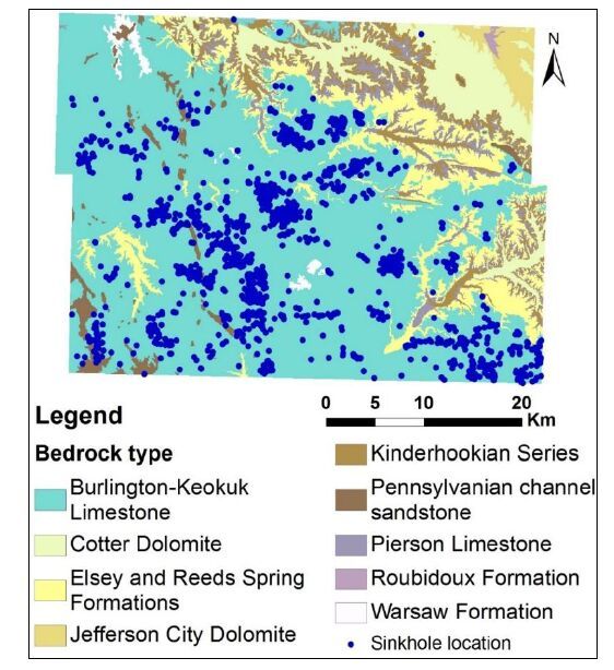
[24] | Fellow LD (1970) Geology of Galloway Quadrangle Greene County Missouri.Missouri Geological Survey and Water Resources 3-14. |
[25] | Hayes WC, Thomson KC (1973) Engineering and environmental geology of the Springfield urban area: Association of Missouri Geologists.20th annual meeting field trip. . |
[26] | Orndorff RC, Weary DJ, Lagueux KM (2000) Geographic information systems analysis of geologic controls on the distribution of dolines in the Ozarks of south-central Missouri.USA. - Acta Carsologica 29/2 161-175. |
[27] | McCracken M (1971) Structural features of Missouri: Rolla, Missouri Department of Natural Resources.Division of Geology and Water Resources . |
1. | Constantin Prins, Kurosch Thuro, Michael Krautblatter, Reinhard Schulz, Testing the effectiveness of an inverse Wenner-Schlumberger array for geoelectrical karst void reconnaissance, on the Swabian Alb high plain, new line Wendlingen–Ulm, southwestern Germany, 2019, 249, 00137952, 71, 10.1016/j.enggeo.2018.12.014 | |
2. | Kenneth Bansah, Neil Anderson, 2017, FACTORS CONTRIBUTING TO KARST DEVELOPMENT IN SOUTHWESTERN MISSOURI, USA, 219, 10.4133/SAGEEP.30-013 | |
3. | Shishay Kidanu, Aleksandra Varnavina, Neil Anderson, Evgeniy Torgashov, Pseudo-3D-electrical resistivity tomography imaging of subsurface structure of a sinkhole—A case study in Greene County, Missouri, 2020, 6, 2471-2132, 54, 10.3934/geosci.2020005 | |
4. | Aleksandra V. Varnavina, Aleksey K. Khamzin, Shishay T. Kidanu, Neil L. Anderson, Geophysical site assessment in karst terrain: A case study from southwestern Missouri, 2019, 170, 09269851, 103838, 10.1016/j.jappgeo.2019.103838 | |
5. | Constantin Prins, Kurosch Thuro, Michael Krautblatter, 2019, Chapter 17, 978-3-319-93129-6, 115, 10.1007/978-3-319-93130-2_17 | |
6. | Constantin Prins, Reinhard Schulz, Kurosch Thuro, Untersuchung der Effektivität einer inversen Wenner‐Schlumberger‐Konfiguration, 2022, 45, 0172-6145, 170, 10.1002/gete.202200006 | |
7. | Serhane Brahmi, Chemsedine Fehdi, Riheb Hadji, Smail Brahmi, Amor Hamad, Younes Hamed, Karst-Induced Sinkhole Detection Using a Tomography Imaging Survey, Case of Setifian High Plain, NE Algeria, 2023, 0960-3182, 10.1007/s10706-023-02384-x | |
8. | P. Anbazhagan, K. Panjami, A Study on the Effectiveness of Various Geophysical Methods in Detecting Naturally Formed Cavities in Lateritic Deposit, 2024, 54, 0971-9555, 1254, 10.1007/s40098-023-00805-5 | |
9. | Mohamed A. Gamal, Mohamed Abdelfattah, George Maher, Investigation and monitoring of rotational landslides in El Mokkattam plateau Egypt, using integrated geological and geophysical techniques, 2024, 10, 24058440, e36545, 10.1016/j.heliyon.2024.e36545 |
System | Series | Group | Formation | Thickness (ft) | |
Mississipian | Osagean | Burlington-Keokuk Formation | 150-270 | ||
Elsey Formation | 25-75 | ||||
Reeds-Spring Formation | 125 | ||||
Pierson Formation | 90 | ||||
Kinkerhookian | Chouteau | Northview Formation | 5-80 | ||
Compton Formation | 30 | ||||
Ordovician | Canadian | Cotter Formation | 600 | ||
Jefferson-City Formation | |||||
Ruobidoux Formation | 150 | ||||
Gasconade Formation | Upper Gasconade Dolomite | 350 | |||
Lower Gasconade Dolomite | |||||
Gunter Sandstone Member | 25 | ||||
Cambrian | Upper | Eminence Formation | 500 | ||
Potasi Formation | |||||
Elvins | Derby-Doerun Formation | ||||
Davis Formation | 150 | ||||
Bonneterre Formation | 200 | ||||
Lamotte Formation | 150 | ||||
Precambrian | Crystalline rock |