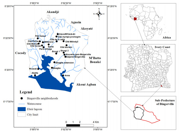
This study aimed to assess the impact of urbanization on land use dynamics and its consequences on the local climate of the town of Bingerville for the period from 1990 to 2020. Land cover classification was based on Landsat data for the years 1990, 2000, 2015, and 2020 in order to perform a diachronic analysis of surface conditions. Precipitation and temperature data were used to assess local climate trends. A number of extreme precipitation indices (PRCPTOT, RR1, SDII, CWD, CDD, R95p, and R99p) and temperature indices (TN10p, TN90p, TX10p, TX90p, and WSDI) were calculated. The results show a sharp increase in the built-up area from 1990 to 2020, with 32.11 km2 (29.68% per year), compared with forest or crops, i.e., 19.09 km2 (0.62% per year), and scrubland or fallow land, i.e., 13.21 km2 (1.39% per year). However, extreme precipitation indices such as annual precipitation (PRCPTOT), rainy days (RR1), consecutive rainy days (CWD), and extremely rainy days (R99p) have increased from 2011 to 2020. In addition, buildings are correlated with RR1 and CWD. This could be one of the key factors contributing to the occurrence of flooding in the town of Bingerville, which is probably linked to urbanization. As for extreme temperature indices, most show a statistically insignificant trend, except for cold days (TX10p) and hot days (TX90p), which have a statistically significant trend of 0.004 and 0.018, respectively. This means that there have been changes in these two indices. Consecutive hot days (WSDI) and TX90p increased from 2010 to 2016, and buildings also correlated with these two indices. Consequently, changes in land use could have an influence on local temperature through the urban heat island (UHI) phenomenon. However, uncontrolled urbanization has an impact on the local climate. The town authorities need to be aware of this, and be rigorous in this area, to avoid future disasters in Bingerville.
Citation: Kinanlie Sandrine Traore, Salomon Obahoundje, Asseypo Célestin Hauhouot, Arona Diedhiou. Impacts of urbanization on land use change and its incidences on the climate: Case of Bingerville City (Ivory Coast, West Africa)[J]. AIMS Geosciences, 2025, 11(1): 228-253. doi: 10.3934/geosci.2025010
This study aimed to assess the impact of urbanization on land use dynamics and its consequences on the local climate of the town of Bingerville for the period from 1990 to 2020. Land cover classification was based on Landsat data for the years 1990, 2000, 2015, and 2020 in order to perform a diachronic analysis of surface conditions. Precipitation and temperature data were used to assess local climate trends. A number of extreme precipitation indices (PRCPTOT, RR1, SDII, CWD, CDD, R95p, and R99p) and temperature indices (TN10p, TN90p, TX10p, TX90p, and WSDI) were calculated. The results show a sharp increase in the built-up area from 1990 to 2020, with 32.11 km2 (29.68% per year), compared with forest or crops, i.e., 19.09 km2 (0.62% per year), and scrubland or fallow land, i.e., 13.21 km2 (1.39% per year). However, extreme precipitation indices such as annual precipitation (PRCPTOT), rainy days (RR1), consecutive rainy days (CWD), and extremely rainy days (R99p) have increased from 2011 to 2020. In addition, buildings are correlated with RR1 and CWD. This could be one of the key factors contributing to the occurrence of flooding in the town of Bingerville, which is probably linked to urbanization. As for extreme temperature indices, most show a statistically insignificant trend, except for cold days (TX10p) and hot days (TX90p), which have a statistically significant trend of 0.004 and 0.018, respectively. This means that there have been changes in these two indices. Consecutive hot days (WSDI) and TX90p increased from 2010 to 2016, and buildings also correlated with these two indices. Consequently, changes in land use could have an influence on local temperature through the urban heat island (UHI) phenomenon. However, uncontrolled urbanization has an impact on the local climate. The town authorities need to be aware of this, and be rigorous in this area, to avoid future disasters in Bingerville.

| [1] |
Li X, Stringer LC, Dallimer M (2022) The Impacts of Urbanisation and Climate Change on the Urban Thermal Environment in Africa. Climate 10: 164. https://doi.org/10.3390/cli10110164 doi: 10.3390/cli10110164

|
| [2] | Denis E (2020) More Urban Constructions for Whom? Drivers of Urban Built-Up Expansion Across the World from 1990 to 2015, In: D Pumain, Ed., Theories and Models of Urbanization, Berlin, Springer, 235–258. https://doi.org/10.1007/978-3-030-36656-8_13 |
| [3] |
Ahmed HA, Singh SK, Kumar M, et al. (2020) Impact of urbanization and land cover change on urban climate: Case study of Nigeria. Urban Clim 32: 100600. https://doi.org/10.1016/j.uclim.2020.100600 doi: 10.1016/j.uclim.2020.100600
|
| [4] | Cahiers de l'Afrique de l'Ouest, Dynamiques de l'urbanisation africaine 2022, le rayonnement économique des villes africaines, OCDE, Nation Unis, 2022,204. https://doi.org/10.1787/20743556 |
| [5] | OECD, United Nations Economic Commission for Africa, African Development Bank (2022) New evidence on Africa's urban economy, Africa's Urbanisation Dynamics 2022: The Economic Power of Africa's Cities, OECD Publishing: Paris, France. |
| [6] |
Zhang M, Chen E, Zhang C, et al. (2024) Multi-Scenario Simulation of Land Use Change and Ecosystem Service Value Based on the Markov–FLUS Model in Ezhou City, China. Sustainability 16: 6237. https://doi.org/10.3390/su16146237 doi: 10.3390/su16146237
|
| [7] | Foissard X, Quenol H, Dubreuil V (2013) Analyse et spatialisation de l'ilot de chaleur urbain dans l'agglomération rennaise, XXVIème colloque de l'Association Internationale de Climatologie, 242–247. Available from: https://www.academia.edu/27969446/Analyse_et_spatialisation_de_lilot_de_chaleur_urbain_dans_lagglom%C3%A9ration_rennaise. |
| [8] | Yao X, Wang Z, Wang H (2015) Impact of urbanization and land-use change on surface climate in middle and lower reaches of the Yangtze River, 1988–2008. Adv Meteorol 10. https://dx.doi.org/10.1155/2015/395094 |
| [9] |
Xu Z, Zhao G (2016) Impact of urbanization on rainfall-runoff processes: case study in the Liangshui River Basin in Beijing, China. Proc Int Assoc Hydrol Sci 373: 7–12. https://doi.org/10.5194/piahs-373-7-2016 doi: 10.5194/piahs-373-7-2016
|
| [10] | Jeune Afrique-Economique, Ville et Climat : Abidjan traque les pluies diluviennes. Dossier article de presse «Comment les villes africaines font face au risque climatique», 2020. Available from: https://www.jeuneafrique.com/dossiers/comment-les-villes-africaines-font-face-au-risque-climatique/. |
| [11] | Kouamé KM, Kouadio BH, Yao JC, et al. (2023) Cartographie du risque d'inondation à cocody et abobo-abidjan (Côte d'Ivoire). Éditions Francophones Universitaires d'Afrique, 430–447. |
| [12] | IPCC, Changements climatiques 2014: Rapport de synthèse. Contribution des Groupes de travail I, II et III au cinquième Rapport d'évaluation du Groupe d'experts intergouvernemental sur l'évolution du climat. GIEC, Genève, Suisse, 2014,161. |
| [13] | Ymba M (2022) Analyse des effets des îlots de chaleur urbains sur la santé des populations de la ville d'Abidjan (Côte d'Ivoire). Les Papiers de la Fondation 46: 24. |
| [14] |
Luo XY, Chen MX (2019) Research progress on the impact of urbanization on climate change. Adv Earth Sci 34: 984. https://doi.org/10.11867/j.issn.1001-8166.2019.09.0984 doi: 10.11867/j.issn.1001-8166.2019.09.0984
|
| [15] |
Chen Y, Yang J, Yu WB, et al. (2020) Relationship between urban spatial form and seasonal land surface temperature under different grid scales. Sustain Cities Soc 89: 104374. https://doi.org/10.1016/j.scs.2022.104374 doi: 10.1016/j.scs.2022.104374
|
| [16] |
Zhang R, Yang J, Ma XY, et al. (2023) Optimal allocation of local climate zones based on heat vulnerability perspective. Sustain Cities Soc 99: 104981. https://doi.org/10.1016/j.scs.2023.104981 doi: 10.1016/j.scs.2023.104981
|
| [17] |
Xu D, Gao J, Lin W, et al. (2021) Differences in the ecological impact of climate change and urbanization. Urban Clim 38: 100891. https://doi.org/10.1016/j.uclim.2021.100891 doi: 10.1016/j.uclim.2021.100891
|
| [18] |
Eba AEL, Ake GE, Gouadou DF, et al. (2021) Evaluation de la Vulnérabilite à lâ€TMInondation des Communes à Proximité des Grandes Villes Ouest Africaines : Cas de la Commune de Bingerville (Est dâ€TMAbidjan â€" CÃxte dâ€TMIvoire). Eur Sci J 17: 277. https://doi.org/10.19044/esj.2021.v17n14p277 doi: 10.19044/esj.2021.v17n14p277
|
| [19] | Brou AL (2018) Les stratégies des résidents des quartiers précaires d'Abidjan face au politique de l'urbanisation; cas de Yaoséhi, Kennedy Clouétcha et Washington, Thèse Unique, 387. |
| [20] | Koutoua AJP (2019) Planification urbaine et développement du grand Abidjan: cas des villes d'Anyama, de Bingerville et de Grand-Bassam, Thèse unique, 342. |
| [21] |
Suman P, Satiprasad S, Pulak M, et al. (2018) Impacts of urbanization on land use /cover changes and its probable implications on local climate and groundwater level. J Urban Manage 7: 70–84. https://doi.org/10.1016/j.jum.2018.04.006 doi: 10.1016/j.jum.2018.04.006
|
| [22] |
He F, Yang J, Zhang Y, et al. (2023) Does partition matter? A new approach to modeling land use change, Computers, Environment and Urban Systems. Comput Environ Urban 106: 102041. https://doi.org/10.1016/j.compenvurbsys.2023.102041 doi: 10.1016/j.compenvurbsys.2023.102041
|
| [23] |
Zhang, M, Yiĝit I, Adigüzel F, et al. (2024) Impact of Urban Surfaces on Microclimatic Conditions and Thermal Comfort in Burdur, Türkiye. Atmosphere 15: 1375. https://doi.org/10.3390/atmos15111375 doi: 10.3390/atmos15111375
|
| [24] |
Obahoundje S, Ofosu E, Akpoti K, et al. (2017) Land use and Land Cover Changes under Climate Uncertainty: Modelling the Impacts on Hydropower Production in Western Africa. Hydrologie 4: 2. https://doi.org/10.3390/hydrology4010002 doi: 10.3390/hydrology4010002
|
| [25] |
Sacré Regis MD, Mouhamed L, Kouakou K, et al. (2020) Using the CHIRPS Dataset to Investigate Historical Changes in Precipitation Extremes in West Africa. Climate 8: 84. https://doi.org/10.3390/cli8070084 doi: 10.3390/cli8070084
|
| [26] |
Kouman KD, Kabo-bah AT, Kouadio BH, et al. (2022) Spatio-Temporal Trends of Precipitation and Temperature Extremes across the North-East Region of Côte d'Ivoire over the Period 1981–2020. Climate 10: 74. https://doi.org/10.3390/cli10050074 doi: 10.3390/cli10050074
|
| [27] | Yapi AF, Kpan OJG, N'guessan BVH, et al. (2024) Analyse des extrêmes de températures de la région de la Marahoué (Centre-Ouest de la Côte d'Ivoire) de 1980–2013. Afr Sci 25: 32–45. |
| [28] |
Obahoundje S, Bi VHN, Kouassi KL, et al (2020) Validation of Three Satellite Precipitation Products in Two South-Western African Watersheds: Bandama (Ivory Coast) and Mono (Togo). Atmos Clim Sci 10: 597–613. https://doi.org/10.4236/acs.2020.104031 doi: 10.4236/acs.2020.104031
|
| [29] | Bassin DL, Du A, Idrissa N, et al. (2018) Variabilité spatiale et tendance de précipitations sur la période 1981–2016 dans le bassin actif du Niger, Centre Béninois de la Recherche Scientifique et Technique, Lettres, Sciences Humaines et Sociales. Cahiers du CBRST 11: 37–56. Available from: https://www.researchgate.net/publication/322641224_VARIABILITE_SPATIALE_ET_TENDANCE_DE_PRECIPITATIONS_SUR_LA_PERIODE_1981-2016. |
| [30] | Henri-Joel AO, Agoh DAP (2022) Exploitation de données chirps et terraclimate pour l'étude des pluies urbaines sur le district autonome d'Abidjan (Côte d'Ivoire). Editions Francophones Universitaires d'Afrique, 32–61. |
| [31] |
Phiri D, Morgenroth J (2017) Développements dans les méthodes de classification de la couverture terrestre de Landsat: Une revue. Remote Sens 9: 967. https://doi.org/10.3390/rs9090967 doi: 10.3390/rs9090967
|
| [32] |
Kouamé YM, Obahoundje S, Diedhiou A, et al. (2019) Climate, Land Use and Land Cover Changes in the Bandama Basin (Côte D'Ivoire, West Africa) and Incidences on Hydropower Production of the Kossou Dam. Land 8: 103. https://doi.org/10.3390/land8070103 doi: 10.3390/land8070103
|
| [33] |
Obahoundje S, Diedhiou A, Ofosu EA, et al (2018) Assessment of Spatio-Temporal Changes of Land Use and Land Cover over South-Western African Basins and Their Relations with Variations of Discharges. Hydrologie 5: 56. https://doi.org/10.3390/hydrology5040056 doi: 10.3390/hydrology5040056
|
| [34] |
Akpoti K, Antwi E, Kabo-bah A (2016) Impacts of Rainfall Variability, Land Use and Land Cover Change on Stream Flow of the Black Volta Basin, West Africa. Hydrology 3: 26. https://doi.org/10.3390/hydrology3030026 doi: 10.3390/hydrology3030026
|
| [35] |
Foody GM (2002) Status of land cover classification accuracy assessment. Remote Sens Environ 80: 185–201. https://doi.org/10.1016/S0034-4257(01)00295-4 doi: 10.1016/S0034-4257(01)00295-4
|
| [36] | Congalton RG, Green K (2008) Assessing the Accuracy of Remotely Sensed Data: Principles and Practices, CRC Press. Boca Raton, Floride, USA, 200. https://doi.org/10.1201/9781420055139 |
| [37] |
Barry AA, Caesar J, Klein Tank AMG, et al. (2018) West Africa Climate Extremes and Climate Change Indices. Int J Climatol 38: e921–e938. https://doi.org/10.1002/joc.5420 doi: 10.1002/joc.5420
|
| [38] |
Bedoum A, Biona CB, Pierre BJ, et al. (2017) Évolution des indices des extrêmes climatiques en république du Tchad de 1960 à 2008. Atmos-Ocean 55: 42–56. https://doi.org/10.1080/07055900.2016.1268995 doi: 10.1080/07055900.2016.1268995
|
| [39] | Kruger AC, Shongwe S (2004) Temperature Trends in South Africa: 1960–2003. Int J Climatol 24: 1929–1945. |
| [40] |
Balliet R, Saley MB, Eba ELA, et al. (2016) Évolution Des Extrêmes Pluviométriques Dans La Région Du Gôh (Centre-Ouest De La Côte d'Ivoire). Eur Sci J 12: 74. http://dx.doi.org/10.19044/esj.2016.v12n23p74 doi: 10.19044/esj.2016.v12n23p74
|
| [41] | Kruger AC, Rautenbach H, Mbatha S, et al. (2019) Historical and Projected Trends in near Surface Temperature Indices for 22 Locations in South Africa. S Afr J Sci 115. https://doi.org/10.17159/sajs.2019/4846 |
| [42] |
Croitoru AE, Chiotoroiu BC, Ivanova Todorova V, et al. (2013) Changes in Precipitation Extremes on the Black Sea Western Coast. Global Planet Change 102: 10–19. https://doi.org/10.1016/j.gloplacha.2013.01.004 doi: 10.1016/j.gloplacha.2013.01.004
|
| [43] | New M, Hewitson B, Stephenson DB, et al. (2006) Evidence of Trends in Daily Climate Extremes over Southern and West Africa. J Geophys Res Atmos 111. https://doi.org/10.1029/2005JD006289 |
| [44] |
Berhane A, Hadgu G, Worku W, et al. (2020) Trends in Extreme Temperature and Rainfall Indices in the Semi-Arid Areas of Western Tigray, Ethiopia. Environ Syst Res 9: 3. https://doi.org/10.1186/s40068-020-00165-6 doi: 10.1186/s40068-020-00165-6
|
| [45] |
Vondou DA, Guenang GM, Djiotang TLA, et al. (2021) Trends and Interannual Variability of Extreme Rainfall Indices over Cameroon. Sustainability 13: 6803. https://doi.org/10.3390/su13126803 doi: 10.3390/su13126803
|
| [46] |
Gebrechorkos SH, Hülsmann S, Bernhofer C (2019) Changes in Temperature and Precipitation Extremes in Ethiopia, Kenya, and Tanzania. Int J Climatol 39: 18–30. https://doi.org/10.1002/joc.5777 doi: 10.1002/joc.5777
|
| [47] |
Obahoundje S, Diedhiou A, Kouassi KL, et al (2022) Analysis of hydroclimatic trends and variability and their impacts on hydropower generation in two river basins in Côte d'Ivoire (West Africa) during 1981–2017. Environ Res Commun 4: 19. https://doi.org/10.1088/2515-7620/ac71fa doi: 10.1088/2515-7620/ac71fa
|
| [48] | Kendall M, Gibbons JD (1938) Méthodes de corrélation des rangs, Londres: Oxford University Press. |
| [49] |
Davis CL, Hoffan MT, Roberts W (2016) Recent Trends in Climate of Namaqualand, a Megadiverse Arid Region of South Africa. S Afr J Sci 112: 9. https://doi.org/10.17159/sajs.2016/20150217 doi: 10.17159/sajs.2016/20150217
|
| [50] |
Zhao L, Zhang C, Wang Q (2024) Climate extremes and land use carbon emissions: Insight from the perspective of sustainable land use in the eastern coast of China. J Cleaner Prod 452: 142219. https://doi.org/10.1016/j.jclepro.2024.142219 doi: 10.1016/j.jclepro.2024.142219
|
| [51] |
Wu L, Zhao C, Li J, et al. (2023) Impact of extreme climates on land surface phenology in Central Asia. Ecol Indic 146: 109832. https://doi.org/10.1016/j.ecolind.2022.109832 doi: 10.1016/j.ecolind.2022.109832
|
| [52] |
Suckall N, Fraser E, Forster P, et al. (2015) Using a migration systems approach to understand the link between climate change and urbanisation in Malawi. Appl Geogr 63: 244–252. https://doi.org/10.1016/j.apgeog.2015.07.004 doi: 10.1016/j.apgeog.2015.07.004
|
| [53] | Oura KR, Kanga KMJ (2017) L'agriculture urbaine face au défi de l'urbanisation de Bingerville dans le Sud-Est d'Abidjan, en Côte d'Ivoire. Dynamiques des territoires et développement 16: 260–280. |
| [54] | Loba ADFV (2010) Les déterminants de la dynamique spatiale de la ville de Bingerville (sud de la Côte d'Ivoire) de 1960 à nos jours. EchoGéo. |
| [55] | BNETD, Projet de développement des communes côtières, communes de Bingerville, 1993, 55. |
| [56] | Aoubouazza M, Rajel R, Essafi R (2019) Impact Des Phénomènes Climatiques Extrêmes Sur Les Ressources En Eau et l' Agriculture Au Maroc. Rev Mar Sci Agron Vét 7: 223–232. |
| [57] |
Van der Walt AJ, Fitchett JM (2021) Exploring Extreme Warm Temperature Trends in South Africa: 1960–2016. Theor Appl Climatol 143: 1341–1360. https://doi.org/10.1007/s00704-020-03479-8 doi: 10.1007/s00704-020-03479-8
|
| [58] | Bambara D, Compaore H, Bilgo A (2018) Évolution des températures au Burkina Faso entre 1956 et 2015: cas de Ouagadougou et de Ouahigouya. Physio-Géo Géographie physique et Environnement 12: 23–41. |
| [59] |
Tam BY, Gough WA, Mohsin T (2015) The impact of urbanization and the urban heat island effect on day to day temperature variation. Urban Clim 12: 1–10. https://doi.org/10.1016/j.uclim.2014.12.004 doi: 10.1016/j.uclim.2014.12.004
|
| [60] |
Chen L, Frauenfeld OW (2016) Impacts of urbanization on future climate in China. Clim Dyn 47: 345–357. https://doi.org/10.1007/s00382-015-2840-6 doi: 10.1007/s00382-015-2840-6
|
| [61] |
Kalnay E, Cai M (2003) Impact of urbanization and land-use change on climate. Nature 423: 528–531. https://doi.org/10.1038/nature01675 doi: 10.1038/nature01675
|
| [62] |
Coumou D, Rahmstorf SA (2012) A decade of weather extremes. Nature Clim Change 2: 491–496. https://doi.org/10.1038/nclimate1452 doi: 10.1038/nclimate1452
|
| [63] | Atcheremi KND, Jourda JPR, Saley MB, et al. (2018) Study of the evolution of the rainfall extremes and temperature extremes in davo river basin (south- western of cote d'ivoire) from some indices of the software rclimdex. Larhyss J 36: 99–117. |
| [64] | Ghohoui YP, Hountondji YC, De Longueville F, et al. (2018) Appercu synoptique de la variabilité des extremes climatique du Bénin (1960–2016). Risques ClimatiquesAIC, 98–102. |
| [65] | Karimou BM, Ambouta K, Sarr B, et al. (2015) Analyse Des Phénomènes Climatiques Extrêmes Dans Le Sud-Est Du Niger. XXVIIIe Colloque de l'Association Internationale de Climatologie: Liège, Belgium, 537–542. Available from: https://orbi.uliege.be/bitstream/2268/184575/1/087-KARIMOU_BARKE-537-542.pdf. |
| [66] |
Abatan AA, Abiodun, BJ, Lawalc KA, et al. (2016) Trends in extreme temperature over Nigeria from percentile-based threshold indices. Int J Climatol 36: 2527–2540. https://doi.org/10.1002/joc.4510 doi: 10.1002/joc.4510
|
| [67] | IPCC, Climate Change 2007: Impacts, Adaptation and Vulnerability. Contribution of Working Group II to the Fourth Assessment Report of the Intergovernmental Panel on Climate Change, Parry ML, Canziani OF, Palutikof JP, et al., Eds., Cambridge University Press: Cambridge, UK, 2007. Available from: https://www.ipcc.ch/site/assets/uploads/2018/03/ar4_wg2_full_report.pdf. |
| [68] |
Mohajerani A, Bakaric J, Jeffrey-Bailey T (2017) The urban heat island effect, its causes, and mitigation, with reference to the thermal properties of asphalt concrete. J Environ Manage 197: 522–538. https://doi.org/10.1016/j.jenvman.2017.03.095 doi: 10.1016/j.jenvman.2017.03.095
|
| [69] |
Goula BTA, Soro EG, Kouassi W, et al. (2012) Trends and abrupt changes in daily extreme rainfalls of Ivory Coast (West Africa). Hydrol Sci J 57: 1067–1080. https://doi.org/10.1080/02626667.2012.692880 doi: 10.1080/02626667.2012.692880
|
| [70] |
Sanogo S, Fink AH, Omotosho JA, et al. (2015) Spatio-temporal characteristics of the recent rainfall recovery in West Africa. Int J Climatol 35: 4589–4605. http://dx.doi.org/10.1002/joc.4309 doi: 10.1002/joc.4309
|
| [71] | Allechy FB, Ta MY, Bi VHG, et al. (2020) Trend of Extreme Precipitations Indices in West-central Côte d'Ivoire: Case of the Lobo Watershed. Eur J Eng Res Sci 5: 1281–1287. |
| [72] | N'guessan HBV, Arona D, Adjakpa T, et al. (2015) Apport de la télédétection à l'analyse spatio-temporelle de l'évolution des extrêmes pluviométriques dans le district d'abidjan au sud de la cote d'ivoire. Mélanges en hommages aux Professeurs Houssou CS, Houndagba CJ Thomas 3: 364–378. |
| [73] |
Larbi I, Hountondji FCC, Annor T, et al. (2018) Spatio-Temporal Trend Analysis of Rainfall and Temperature Extremes in the Vea Catchment, Ghana. Climate 6: 87. https://doi.org/10.3390/cli6040087 doi: 10.3390/cli6040087
|
| [74] | Ozer P, Manzo L, Tidjani AD, et al. (2017) Evolution Récente Des Extrêmes Pluviométriques Au Niger (1950–2014). Geo-Eco-Trop: Revue Internationale de Géologie, de Géographie et d'Ecologie Tropicales 41: 375–383. |
| [75] |
Donat MG, Alexander LV, Yang H, et al. (2023) Updated Analyses of Temperature and Precipitation Extreme Indices since the Beginning of the Twentieth Century: The HadEX2 Dataset. J Geophys Res Atmos 118: 2098–2118. https://doi.org/10.1002/jgrd.50150 doi: 10.1002/jgrd.50150
|
| [76] | Balliet R (2017) Impacts du changement climatique et de la pression anthropique sur l'environnement naturel et humain de la région du Gôh (Centre-ouest de la Côte d'Ivoire): analyse de mesures endogènes d'adaptation. Thèse unique, Université Félix Houphouët Boigny, 193. |
| [77] |
Panthou G, Vischel T, Lebel T (2014) Recent Trends in the Regime of Extreme Rainfall in the Central Sahel. Int J Climatol 34: 3998–4006. https://doi.org/10.1002/joc.3984 doi: 10.1002/joc.3984
|
| [78] | Mobio ABH, Dré KF, Kouamé AKD, et al. (2017) Contribution de la Télédétection à l'étude de la Distribution spatiale de la Température en fonction du relief et du mode d'occupation du Sol: Cas de la ville d'Abidjan (Côte d'Ivoire). Int J Eng Sci Invent 6: 48–55. |
| [79] | Drápela K, Drápelová I (2011) Application du test de Mann-Kendall et des estimations de la pente de Sen pour la détection des tendances dans les données de dépôt de Bílý Kříž (Monts Beskydy, République tchèque) 1997–2010. Base de Donnée CABI 4: 133–146. |


Figures(5) / Tables(3)

Kinanlie Sandrine Traore, Salomon Obahoundje, Asseypo Célestin Hauhouot, Arona Diedhiou. Impacts of urbanization on land use change and its incidences on the climate: Case of Bingerville City (Ivory Coast, West Africa)[J]. AIMS Geosciences, 2025, 11(1): 228-253. doi: 10.3934/geosci.2025010


 DownLoad: