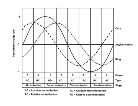
Since the beginning of settled civilizations, cities have represented places of innovation and meeting points for flows of goods, services, people, ideas, and cultural expressions. Cities as places of interaction help to develop new ideas, solutions, and applications. If the spreading of innovation in the past appeared as a spontaneous process, nowadays it is inserted into more structured business models for enterprises and companies and in development policies at central, regional, and local levels. This also involves cities, as investing in innovation can represent opportunities for their growth. Urban geography literature, for instance, examines the urban life cycle, which has evolved into what Florida terms the "New Urban Crisis". Based on the "demographic winter" facing Italy and other industrialized countries, the present work aims to observe the most recent urban dynamics in spatial and demographic changes, innovation, and digital transitions. This research combined an analysis of innovative cities in Italy, based on the innovation index (ICity Rank) with demographic data, considering metropolitan cities and their functional urban areas (FUAs), along with a set of mid-sized cities identified as "innovative" and dynamic. Cities were ranked within the urban life cycle model, employing LISA (Local Moran's I) as a method for analysis and clustering. Using spatial analytical techniques, the work focused on the Italian urban system, its capital cities and mid-size innovative cities, considering urban dynamics in terms of population change, income, and innovation, observing their characteristics and recent evolution (2019–2023). The findings highlight the formation of urban "champions" and their characteristics in terms of ability to attract people and expertise. The results show that innovative metropolitan cities are able to maintain population levels, particularly in suburban rings, while populations in the core areas tend to decline. However, certain innovative metropolitan cities in Southern Italy maintained or increased the core population. In general, medium-sized cities present more interesting dynamics, showing either population stability or a slower rate of decline.
Citation: Giuseppe Borruso, Ginevra Balletto. Cities as innovation poles in the digital transition. The Italian case[J]. AIMS Geosciences, 2024, 10(4): 918-938. doi: 10.3934/geosci.2024043
Since the beginning of settled civilizations, cities have represented places of innovation and meeting points for flows of goods, services, people, ideas, and cultural expressions. Cities as places of interaction help to develop new ideas, solutions, and applications. If the spreading of innovation in the past appeared as a spontaneous process, nowadays it is inserted into more structured business models for enterprises and companies and in development policies at central, regional, and local levels. This also involves cities, as investing in innovation can represent opportunities for their growth. Urban geography literature, for instance, examines the urban life cycle, which has evolved into what Florida terms the "New Urban Crisis". Based on the "demographic winter" facing Italy and other industrialized countries, the present work aims to observe the most recent urban dynamics in spatial and demographic changes, innovation, and digital transitions. This research combined an analysis of innovative cities in Italy, based on the innovation index (ICity Rank) with demographic data, considering metropolitan cities and their functional urban areas (FUAs), along with a set of mid-sized cities identified as "innovative" and dynamic. Cities were ranked within the urban life cycle model, employing LISA (Local Moran's I) as a method for analysis and clustering. Using spatial analytical techniques, the work focused on the Italian urban system, its capital cities and mid-size innovative cities, considering urban dynamics in terms of population change, income, and innovation, observing their characteristics and recent evolution (2019–2023). The findings highlight the formation of urban "champions" and their characteristics in terms of ability to attract people and expertise. The results show that innovative metropolitan cities are able to maintain population levels, particularly in suburban rings, while populations in the core areas tend to decline. However, certain innovative metropolitan cities in Southern Italy maintained or increased the core population. In general, medium-sized cities present more interesting dynamics, showing either population stability or a slower rate of decline.

| [1] |
Saleh R, Brem A (2023) Creativity for sustainability: An integrative literature review. J Cleaner Prod 388: 135848. https://doi.org/10.1016/j.jclepro.2023.135848 doi: 10.1016/j.jclepro.2023.135848

|
| [2] |
Cohen B (2006) Urbanization in developing countries: Current trends, future projections, and key challenges for sustainability. Technol Soc 28: 63–80. https://doi.org/10.1016/j.techsoc.2005.10.005 doi: 10.1016/j.techsoc.2005.10.005
|
| [3] |
Sato Y, Yamamoto K (2005) Population concentration, urbanization, and demographic transition. J Urban Econ 58: 45–61. https://doi.org/10.1016/j.jue.2005.01.004 doi: 10.1016/j.jue.2005.01.004
|
| [4] |
Cividino S, Halbac-Cotoara-Zamfir R, Salvati L (2020) Revisiting the "City Life Cycle": Global Urbanization and Implications for Regional Development. Sustainability 12: 1151. https://doi.org/10.3390/su12031151 doi: 10.3390/su12031151
|
| [5] | McCann P (2017) Urban futures, population ageing and demographic decline. Camb J Reg Econ Soc 10: 543–557. |
| [6] |
Alonso W (1960) A Theory of The Urban Land Market. Pap Reg Sci 6: 149–157. https://doi.org/10.1111/j.1435-5597.1960.tb01710.x doi: 10.1111/j.1435-5597.1960.tb01710.x
|
| [7] | Van den Berg L, Roy Drewett R, Klaassen LH (1982) A Study of Growth and Decline. Urban Europe. Vol. 1, Pergamon Press. |
| [8] |
Koomen E, Van Bemmel MS, Van Huijstee J, et al. (2023) An integrated global model of local urban development and population change. Comput Environ Urban Syst 100: 101935. https://doi.org/10.1016/j.compenvurbsys.2022.101935 doi: 10.1016/j.compenvurbsys.2022.101935
|
| [9] |
Seyedabadi MR, Eicker U (2023) A critical review of urban scale life cycle assessment of the built environment. Sustainability Anal Model 3: 100026. https://doi.org/10.1016/j.samod.2023.100026 doi: 10.1016/j.samod.2023.100026
|
| [10] |
Dyson T (2011) The role of the demographic transition in the process of urbanization. Popul Dev Rev 37: 34–54. https://doi.org/10.1111/j.1728-4457.2011.00377.x doi: 10.1111/j.1728-4457.2011.00377.x
|
| [11] | Florida R (2017) The new urban crisis: How our cities are increasing inequality, deepening segregation, and failing the middle class-and what we can do about it. London: Hachette UK |
| [12] |
Egidi G, Cividino S, Vinci S, et al. (2020) Towards Local Forms of Sprawl: A Brief Reflection on Mediterranean Urbanization. Sustainability 12: 582. https://doi.org/10.3390/su12020582 doi: 10.3390/su12020582
|
| [13] |
Henderson JV, Venables AJ (2009) The dynamics of city formation. Rev Econ Dyn 12: 233–254. https://doi.org/10.1016/j.red.2008.06.003 doi: 10.1016/j.red.2008.06.003
|
| [14] | Cuthbert AR (2008) The form of cities: Political economy and urban design. John Wiley & Sons. https://doi.org/10.1002/9780470774915 |
| [15] |
Borruso G, Balletto G (2022) The image of the smart city: New challenges. Urban Sci 6: 5. https://doi.org/10.3390/urbansci6010005 doi: 10.3390/urbansci6010005
|
| [16] | Bezrukikh VA, Kuznetsova OA, Ligaeva NA, et al. (2018). Current systems of protected areas integrated with urban agglomerations. In IOP Conference Series: Materials Science and Engineering 463: 042055. https://doi.org/10.1088/1757-899X/463/4/042055 |
| [17] | OECD European Commission (2020) A new perspective on urbanization, OECD European Commission. Available from: https://www.oecd.org/publications/cities-in-the-world-d0efcbda-en.htm |
| [18] |
Schiavina M, Melchiorri M, Freire S, et al. (2022) Land use efficiency of functional urban areas: Global pattern and evolution of development trajectories Habitat Int 123: 102543. https://doi.org/10.1016/j.habitatint.2022.102543 doi: 10.1016/j.habitatint.2022.102543
|
| [19] | Sestini A (1949) Le regioni italiane come base geografica della struttura dello stato, In: AA.VV., Atti del XIV Congresso Geografico Italiano (Bologna 8–12 aprile 1947), Bologna, Zanichelli: 128–143. |
| [20] | Gambi L (1963) L'equivoco fra compartimenti statistici e regioni costituzionali, Faenza: Lega. |
| [21] | Cori B (2006) Geografia Urbana, Utet: Torino. |
| [22] | Memoli M, Governa F (2011) Geografia dell'Urbano. Spazi, politiche, pratiche della città, Roma: Carocci. |
| [23] | Donolo C (2012) Sul governo possibile delle città, In: Dematteis G. (ed), Le grandi città italiane. Società e territori da ricomporre, Venezia: Marsilio, 175–206. |
| [24] | Castelnovi M (2013) Il riordino territoriale dello Stato. Riflessioni e proposte della geografia italiana, Roma: Società Geografica Italiana. |
| [25] | Dini F, Zilli S (2015), Il riordino territoriale dello Stato. Roma: Società Geografica Italiana. |
| [26] | Benetazzo C (2019) Le Province a cinque anni dalla legge "Delrio": profili partecipativi e funzionali organizzativi. Federalismi.it 5: 2–49. |
| [27] | Dini F, Zilli S (2019) Neo centralismo e territorio fra Città metropolitane, aree vaste e intercomunalità. Introduzione, In: Salvatori F. (ed.), L'apporto della Geografia fra rivoluzioni e riforme, Roma: AGeI, 2213–2218. |
| [28] | Scaramellini G (1990) Funzioni centrali, funzioni metropolitane, reti urbane, Milano: Franco Angeli. |
| [29] |
Salone C, Governa F (2005) Italy and European spatial policies: polycentrism, urban networks and local innovation practices. Eur Plann Stud 13: 265–283. https://doi.org/10.1080/0965431042000321820 doi: 10.1080/0965431042000321820
|
| [30] | Crisci M, Gemmiti R, Proietti E, et al. (2014) Urban sprawl e shrinking cities in Italia. Trasformazione urbana e redistribuzione della popolazione nelle aree metropolitane, IRES, CNR. |
| [31] | Turri E (2000) La megalopoli padana, Marsilio, Padova. |
| [32] | OECD (2012) Redefining "Urban": A New Way to Measure Metropolitan Areas, Paris: OECD Publishing. https://doi.org/10.1787/9789264174108-en. |
| [33] | Dijkstra L, Poelman H, Veneri P (2019) The EU-OECD definition of a functional urban area OECD Regional Development Working Papers, 11, Paris: OECD Publishing. https://doi.org/10.1787/d58cb34d-en. |
| [34] | ISTAT Demografia in cifre, Popolazione residente per sesso, età e stato civile al 1° gennaio 2023, 2024. Available from: https://demo.istat.it/app/?i = POS & l = it. |
| [35] | ISTAT, Demografia in cifre, Popolazione residente per sesso, età e stato civile al 1° gennaio 2019, 2020. Available from: https://demo.istat.it/app/?l = it & a = 2019 & i = POS |
| [36] | ISTAT, BASI TERRITORIALI E VARIABILI CENSUARIE, 2024. Available from: https://www.istat.it/it/archivio/104317 |
| [37] | ForumPA (2019) ICity Rank – Rapporto Annuale 2019, ForumPA. Available from: https://profilo.forumpa.it/doc/?file = 2019/i_city_rank_2019.pdf |
| [38] |
Moreno-Monroy AI, Schiavina M, Veneri P (2021) Metropolitan areas in the world. Delineation and population trends J Urban Econ 125: 103242. https://doi.org/10.1016/j.jue.2020.103242 doi: 10.1016/j.jue.2020.103242
|
| [39] | Tobler WR (1970) A Computer Movie Simulating Urban Growth in the Detroit Region. Econ Geogr 46: 234–240. |
| [40] | Murgante B, Scorza F (2023) Autocorrelazione Spaziale e Pianificazione del Territorio: Principli ed Applicazioni, Libria: Melfi. |
| [41] |
Ceci M, Corizzo R, Malerba D, et al. (2019) Spatial autocorrelation and entropy for renewable energy forecasting. Data Min Knowl Disc 33: 698–729. https://doi.org/10.1007/s10618-018-0605-7 doi: 10.1007/s10618-018-0605-7
|
| [42] |
Luo Q, Griffith DA, Wu H (2019) Spatial autocorrelation for massive spatial data: verification of efficiency and statistical power asymptotics J Geogr Syst 21: 237–269. https://doi.org/10.1007/s10109-019-00293-3 doi: 10.1007/s10109-019-00293-3
|
| [43] | O' Sullivan D, Unwin D (2002) Geographic Information Analysis, Chichester: Wiley. |
| [44] |
Guerra Y (2022) Il ruolo delle città metropolitane alla luce della sentenza n. 240 del 2021: governance metropolitana e funzioni. Le Regioni 50: 499–517. https://doi.org/10.1443/106522 doi: 10.1443/106522
|
| [45] | Borruso G, Balletto G (2024) The Urban Life Cycle in the Italian Demographic Winter. An Analysis on Metropolitan Cities. In: Gervasi O, Murgante B, Garau C, et al. (eds), Computational Science and Its Applications – ICCSA 2024 Workshops. ICCSA 2024. Lecture Notes in Computer Science, vol 14817. Springer, Cham. https://doi.org/10.1007/978-3-031-65238-7_11 |
 geosci-10-04-043-s001.pdf geosci-10-04-043-s001.pdf |
 |


Figures(6) / Tables(6)

Giuseppe Borruso, Ginevra Balletto. Cities as innovation poles in the digital transition. The Italian case[J]. AIMS Geosciences, 2024, 10(4): 918-938. doi: 10.3934/geosci.2024043


 DownLoad: