Citation: Dhanya Praveen, Ramachandran Andimuthu, K. Palanivelu. The urgent call for land degradation vulnerability assessment for conserving land quality in the purview of climate change: Perspective from South Indian Coast[J]. AIMS Agriculture and Food, 2016, 1(3): 330-341. doi: 10.3934/agrfood.2016.3.330
[1] | A. Nurbekov, A. Akramkhanov, A. Kassam, D. Sydyk, Z. Ziyadaullaev, J.P.A. Lamers . Conservation Agriculture for combating land degradation in Central Asia: a synthesis. AIMS Agriculture and Food, 2016, 1(2): 144-156. doi: 10.3934/agrfood.2016.2.144 |
[2] | Janice Liang, Travis Reynolds, Alemayehu Wassie, Cathy Collins, Atalel Wubalem . Effects of exotic Eucalyptus spp. plantations on soil properties in and around sacred natural sites in the northern Ethiopian Highlands. AIMS Agriculture and Food, 2016, 1(2): 175-193. doi: 10.3934/agrfood.2016.2.175 |
[3] | Helmi Helmi, Hairul Basri, Sufardi, Helmi Helmi . Analysis of soil water balance and availability on several land use types for hydrological disaster mitigation in Krueng Jreu Sub-watershed. AIMS Agriculture and Food, 2020, 5(4): 950-963. doi: 10.3934/agrfood.2020.4.950 |
[4] | I. Bashour, A. AL-Ouda, A. Kassam, R. Bachour, K. Jouni, B. Hansmann, C. Estephan . An overview of Conservation Agriculture in the dry Mediterranean environments with a special focus on Syria and Lebanon. AIMS Agriculture and Food, 2016, 1(1): 67-84. doi: 10.3934/agrfood.2016.1.67 |
[5] | Firoz Ahmad, Laxmi Goparaju, Abdul Qayum . Agroforestry suitability analysis based upon nutrient availability mapping: a GIS based suitability mapping. AIMS Agriculture and Food, 2017, 2(2): 201-220. doi: 10.3934/agrfood.2017.2.201 |
[6] | Guizhen Wang, Limin Hua, Victor R. Squires, Guozhen Du . What road should the grazing industry take on pastoral land in China?. AIMS Agriculture and Food, 2017, 2(4): 354-369. doi: 10.3934/agrfood.2017.4.354 |
[7] | Theodor Friedrich, Amir Kassam . Food security as a function of Sustainable Intensification of Crop Production. AIMS Agriculture and Food, 2016, 1(2): 227-238. doi: 10.3934/agrfood.2016.2.227 |
[8] | Emilio J. González-Sánchez, Amir Kassam, Gottlieb Basch, Bernhard Streit, Antonio Holgado-Cabrera, Paula Triviño-Tarradas . Conservation Agriculture and its contribution to the achievement of agri-environmental and economic challenges in Europe. AIMS Agriculture and Food, 2016, 1(4): 387-408. doi: 10.3934/agrfood.2016.4.387 |
[9] | Simon Wambui Mburu, Gilbert Koskey, Ezekiel Mugendi Njeru, John M. Maingi . Revitalization of bacterial endophytes and rhizobacteria for nutrients bioavailability in degraded soils to promote crop production. AIMS Agriculture and Food, 2021, 6(2): 496-524. doi: 10.3934/agrfood.2021029 |
[10] | Helena Hanusová, Karolína Juřenová, Erika Hurajová, Magdalena Daria Vaverková, Jan Winkler . Vegetation structure of bio-belts as agro-environmentally-climatic measures to support biodiversity on arable land: A case study. AIMS Agriculture and Food, 2022, 7(4): 883-896. doi: 10.3934/agrfood.2022054 |
Declining soil quality has posed remarkable challenge for increasing agricultural productivity, economic growth, and environmental health [1]. The fundamental causes for land quality degradation are largely associated with improper land use and soil management, irregular and erosive rainfall, steep terrain, deforestation, and overgrazing [2]. Semi-arid tropics of Asia are characterized by the presence of inadequate and variable rainfall along with the occurrence of frequent droughts and dry spells. Low and medium income countries including India mostly rely on agriculture for rural livelihoods and development. Nevertheless, agricultural systems in developing countries are adversely affected by huge pressure on land and climate change, both of which threaten food production [3,4]. The steady decrease in soil fertility due to many drivers is a serious constraint for sustainable agriculture in many developing countries [5,6,7]. It has been reported that topsoil erosion can cause most detrimental effects on soil quality and is likely to be aggravated by long-term removal of surface litter and crop residues in many parts of the world [8]. Soil organic carbon (SOC) has a vital role in the global carbon cycle and associated climate change. In this context it is highly coherent that any loss of SOC will have dramatic impacts on the sustainability of ecosystem. Grassland degradation notably plays down SOC stocks by 16% in dry climates (<1000 mm). The types of plants under cultivation also plays a key role in diminishing SOC content under C3 grass species, degradation caused SOC losses of up to 14% compared to 4% in C4 grasses [9]. Grassland degradation significantly reduced SOC stocks by 16% in dry climates (1000 mm) and Asia was the most affected continent (23.7%) [10] . Annual soil losses up to 25 Mg ha−1 have been recorded, most of which are recorded in a small number of events. The increase in the incidence of precipitation extremes may have an additional impact, due to greater water volumes being lost to runoff meaning less water infiltration and storage in the soil and an increase in the erosion processes [11].
It is very significant to note that land and soil degradation vulnerability means not only loss of land and soil but also of vulnerability of losing the land and soil functions in the wider contexts (Figure 1). The underlying forces behind the processes of land and soil degradation has to be monitored and assessed in all spatial and temporal scales to arrest the mammoth loss in land quality.
So far, the relative effect of degradation on SOC stocks has been difficult to predict because of the paucity of data [12]. Understanding this background, this study tries to get glimpses of present and future land quality from three different dimensions (a) possible variations in Climatic characteristics through simulations; (b) Soil survey and analysis for understanding the status of key indicator, SOC; (c) trend in past the sea level from the changing climatic lens. This is very much required at this level for sustainable and effective management of land a holistic approach—linking physical, climatic, social and economic aspects.
The study area in the State of Tamil Nadu in the south India spans between the latitudes 12°0ʹ and 13°40ʹN and 79°0ʹ to 80°20ʹE longitude in the east coast bordering Bay of Bengal (Figure 2). Thiruvallur district forms part of northeast agro-climatic zones of the state. It is situated adjacent to the Chennai metropolitan city which was famous for its recent flash floods in December 2015. It is the most heavily populated district of Tamil Nadu. It has a coastline of 27.9 km and located adjacent to Chennai Metropolitan City, the fourth largest metropolis in India. The general slope of the study area is from northwest to southeast. This area has an elevation of 50-200 m above mean sea level. The coastline is bounded on the north by Pulicat Lake, which is the second largest lagoon in the country.
The interior part of this region is categorized as tropical semiarid while the coastal parts are categorized as dry sub humid climate. This area receives rain under the influence of both southwest and northeast monsoons. Under the Drought Prone Area Programme, Kancheepuram and Thiruvallur Districts come under the semiarid category of dry land classification [13]. This district comprises of seven administrative divisions known as “taluks” namely Ponnary, Poonamallee, Ambathur, Gummidipundi, Uttukkottai, Pallipattu and Tiruttani. Seven villages are situated in the 200 m coastal regulation zone (CRZ) and 500 m CRZ lines. The mean annual rainfall is around 1200 mm. The entire coast is affected by gales and cyclones during North East Monsoon. It is significant to note that Thiruvallur district shows the second highest decennial growth rate of 35.25% in the period 2001-2011. Coastal areas of this district was affected by 2004, Tsunamis 2004 especially the taluks Ambathur, Ponneri and Uthukottaihad witnessed death of 29 people. Around 388.37 km2 of the total area is occupied by barren land, otherwise known as waste land [14].
The mean minimum and maximum temperatures are 17 and 33 °C, respectively, and the months between April and June are generally very hot with temperature going up to an average of 37.9 °C. During the winter (December-January) the average temperature is 18.5 °C and the average annual rainfall is 800-1600 mm.
Dynamical downscaling using the Regional Climate Model (RCM), Version 4 (RegCM4.0) of Abdus Salam International Centre for Theoretical Physics (ICTP), Italy was used to simulate the future climate under IPCC AR5 under the latest Representative Concentration Pathway (RCP) 4.5. The GCM boundaries utilized to drive the RCMs were HadGEM2-ES. The simulation output for the period 2070-2098 (end century) period were utilized to project and assess the changes in aridity situations under RCP 4.5 pertaining to south west monsoon region for the study region.
The Representative Concentration Pathway 4.5 (RCP 4.5) is said to be in good coherence with the climate of Indian sub-continent was chosen for simulation [15]. This representative concentration pathway was chosen as it closely comes to the observed climatic conditions of Indian scenario and as that of the previous IPCC SRES A1B scenario. The period of study chosen was from 1971-2098 (128 years), considering (1970-2000) as baseline, 2010-2040 (near century), 2041-2070 (mid century), 2071-2098 (end century).
UNCCD Aridity Index (AI) is used as one of the base methods for determining dry land types in the study area and assessing their vulnerability to the desertification processes. Meteorological variables were frequently employed to generate aridity indices to assess the temporal and spatial trend of aridity such as De Martonne Aridity Index (DMI), UNEP Aridity Index etc. Many scientists have analyzed the annual and seasonal temperature precipitation series and carried out annual aridity indices. Their outcomes reveal that the sites which are currently at the limit with respect to available water resources in semi-arid regions are likely to be most sensitive to climate change [13,14,15,16,17].
Following the UNEP [18], AI classes are shown in the Table 1.
Type of the climate | Values of DMI |
Dry | DMI < 10 |
Semi-arid-dry | 10 ≤ DMI ≤ 20 |
Mediterranean | 20 ≤ DMI < 24 |
Semi-humid | 24 ≤ DMI < 28 |
Humid | 28 ≤ DMI < 35 |
Very humid | a. 35 ≤ DMI ≤ 55 b. DMI > 55 |
The study region was divided into 5 km × 5 km grids. Soil samples were randomly collected from each grid during the period June 2013 and its geographical coordinates were noted. All samples were shade-dried, pulverized with an agate mortar, and then sieved (0.2 mm) before analysis. The samples were analyzed following standard methods. SOC was analyzed in CHSN/O elemental analyzer.
Simulated changes in climate in the study area under RCP 4.5 showed future warming in the study region both in terms of daytime and night time temperatures. Both the simulated mean maximum and minimum temperature showed significant warming. The projections showed a rise in maximum temperature of 2.4 °C under RCP 4.5 by the end of 21st century. The annual mean minimum temperature was projected to rise by 2.3 °C by the end century. The latest simulation study reported by Chaturvedi et al. [15] indicated a rise in temperature in the range of 2.9 to 3.3 °C under RCP 4.5 and RCP 6 pathways.
In a changing climatic context, quantitative examinations of the possible changes in the aridity condition are very essential for understanding future status of land degradation. The spatial distribution of projected aridity during the monsoon period is shown Figure 3. It shows the changes in aridity values under RCP 4.5 Pathway. It reaffirms the area to be semi-arid characterizes that aridity conditions are going to be worsened in the study area. Especially Puzhal, Minjur, Gummidipundi, Sholavaram administrative blocks may likely more dry in future as the simulated aridity values tend to decline in the ranges of −3.25 to −7.5 mm/ °C in the end of 21st century. There was a clear variation in dryness which is noted from the interior areas to the coastal stretch. The Pulicat lake area which forms part of district Minjur comes under the special Ecological Economic Zone of the state is likely to experience more drying in future.
The researchers such as Croitoru, Hrnjakand and Paltineanu [13,19,20] have also employed aridity indices, DMI and the Pinna Combinative Index in order to identify critical areas in the most important agricultural regions of Romania that are prone to aridity. The coastal areas of Thiruvallur district is a potential shrimp farming area, making this area more susceptible to further soil and land degradation. Amongst the coastal districts of Tamil Nadu, Thiruvallur district has witnessed an increase in aquaculture activities.
Based on above analysis, we can conclude that AI can be used as an effective tool to project future aridity conditions.
The organic carbon content in the soil (SOC) has been proposed to be used as an indicator of the soil health level assessments. The field sample analysis reveals that the mean SOC in the study area is 0.43% which is very less than the world averages (Figure 4).
Climate can impose constraints on the processes that control SOC stabilization, which may result in depletion of SOC under different environmental conditions [21]. It is important to note the results revealed by yet another research study conducted using empirical data from 240 runoff plots over entire rainy season from different region of the world indicating that the median particulate organic carbon (POC) losses (POC1) by sheet erosion was 9.9 g C m−2/year with highest values observed in the semi-arid soils followed by the soils found in the tropical regions [11]. It has been reported that the increased convection at high temperatures due to global warming may results in high intensity rainfall at the leeward region. This may lead to flash flooding in Indian regions [22,23]. In a broader sense it can be concluded that a regime with high intensity precipitation due to climate change and cyclonic disturbances in India heightens the risk of soil erosion, runoff, and related environmental and ecological damages [11,24,25].
Apart from that this area is a coastal track, so highly prone to sea level rise as well. The results from the NOAA revealed that SLR trends for Chennai station, Thiruvallur coast has risen by 0.32 mm for the period 1900 to 2010 (Figure 5). Rising sea levels have important direct impacts on coastal and island regions where a substantial percentage of the world’s population lives [26]. Salinization has already been reported in the study area occurs generally because of inadequately managed or maintained irrigation systems, particularly in arid and semi-arid areas [14,27]. Indeed, for the soils prone to Salinization due to high evaporation rates and upward concentration of salts due to capillarity, large amounts of irrigation water are required to not only meet crop requirements but also leach out collected salts from the root zone. Coastal areas near mudflats, salt marshes and lagoon were inundated extensively causing threat to the communities present near the coast, which emphasize careful planning of coastal zone development and management by Parthasarathy [20].
Vulnerability of an area is purely dependent on its natural settings, its climatic and the socio economic conditions. It is very necessary to understand the interactions of climate change impact on one sector with changes in exposure and vulnerability, as well as adaptation and mitigation actions affecting the same or a different sector at regional or sub regional scales thus vary across temporal and spatial scales [29] vulnerability on land degradation in the context of climate change also varies across geographical and temporal scales and must be addressed within complex and uncertain conditions and hence calls for interdisciplinary and multiple expertise [29,30].Vulnerability can be as “a function of exposure, sensitivity and adaptive capacity”. The term “exposure” addresses the incidence of climate change impacts, the term “sensitivity” addresses the capacity of actors to be affected by climate change impacts and the term “adaptive capacity” or “resilience” [29,30,31,32,33]. The lack of a comprehensive conceptual framework that facilitates an integrated assessment impedes the effectiveness of land degradation management and adaptation to climate change [25].
Hence, in this situation, it is very difficult to assess the exact magnitude of land degradation risk unless otherwise a comprehensive land degradation vulnerability assessment is carried out for the study region. The detailed methodology can be obtained from Ramachandran et al. [34,35]. Therefore, further research will be done for assessing forecasting future vulnerability of land degradation of this area with respect to changed change scenario. The future endeavor would likely involve a framework for assessment involving the all the key component of vulnerability, the conceptual framework is dealt here below as Figure 6.
This study was an effort to understand the present and future possible land degradation possibility of the north coastal areas of the state Tamil Nadu. The simulation outcomes of aridity reveal more drying trends in the end century period under RCP 4.5 trajectory. An attempt was also
done to understand the real time situation of soil organic carbon in the area through soil sampling and analysis which implies the poor status of SOC which far below the international standards. Yet, another challenge which may affect the land quality in the purview of climate change was sea level rise. Through this paper we also looked into the SLR matter and got an idea that this area is prone to sea level rise as well. Lessons learnt from the recent floods of Chennai 2015, confirms that parts of this study region is prone to devastating extreme climate events also. With this understanding and the anticipations on a combination of likely increase in warming, aridity and sea levels, this study provides a promising framework and conclusion that there is a need to carry out integrated land degradation vulnerability assessment to evade long and short term setbacks in land quality.
The first author expresses sincere acknowledgement for the Anna Centenary Research Fellowship Fund, under the Department of Civil Engineering, Anna University, Chennai for awarding research fellowship and the entire CCAR team who helped to carry out field works for collecting soil samples.
The authors declare that there is no conflict of interest for this paper.
[1] | Eswaran H, Lal R, Reich PF (2001) Land degradation: an overview. In: Bridges EM, Hannam ID, Oldeman LR, Penning De Vries FWT, Scherr JS, and Sombatpanit S, Eds. Response to Land Degradation, Science Publishers, Enfield, NH, USA. 20-35. |
[2] |
Girmay G, Singh BR, Mitiku H, et al. (2008) Carbon stocks in Ethiopian soils in relation to land use and soil management. Land Degrad Dev 19: 351-367. doi: 10.1002/ldr.844
![]() |
[3] | Singh NP, Bantilan MCS (2009) Climate Change Resilience in Agriculture: Vulnerability and Adaptation Concerns of Semi-Arid Tropics in Asia. In: Proceedings of the Indo-US workshop on Emerging issues in water management for sustainable agriculture in South Asia region, 10-12 Dec 2009, CSWCRTI, Ooty, Udagmandalam. |
[4] |
Füssel HM (2007) Vulnerability: A Generally Applicable Conceptual framework for Climate Change Research. Glob Environ Chang 17: 155-167. doi: 10.1016/j.gloenvcha.2006.05.002
![]() |
[5] |
Füssel HM, Klein RJT (2006) Climate change vulnerability assessments: An evolution of conceptual thinking. Clim Chang 75: 301-329. doi: 10.1007/s10584-006-0329-3
![]() |
[6] | TERI, The Energy and Resources Institute. Adaptation to Climate Change in the Context of Sustainable Development. Background paper, New Delhi, India. 2005. Available from: http://www.teriin.org/events/docs/adapt.pdf |
[7] |
Mbow C, Mertz O, Diouf A, et al. (2008) The history of environmental change and adaptation in eastern Saloum – Senegal. Driving forces and perceptions. Glob Planet Chang 64: 210-221. doi: 10.1016/j.gloplacha.2008.09.008
![]() |
[8] |
Muchena FN, Onduru DD, Gachini GN, et al. (2005) Turning the tides of soil degradation in Africa: capturing the reality and exploring opportunities. Land Use Policy 22: 23-31. doi: 10.1016/j.landusepol.2003.07.001
![]() |
[9] |
Dlamini P, Chivenge P, Manson A, et al. (2014) Land degradation impact on soil organic carbon and nitrogen stocks of sub-tropical humid grasslands in South Africa. Geoderma 235-236: 372-381. doi: 10.1016/j.geoderma.2014.07.016
![]() |
[10] |
Ramos MC, Martínez-Casasnovas JA (2009) Impacts of annual precipitation extremes on soil and nutrient losses in vineyards of NE Spain. Hydrol Process 23: 224-235. doi: 10.1002/hyp.7130
![]() |
[11] |
Muller-Nedebock D, Chaplot V (2015) Soil carbon losses by sheet erosion: a potentially critical contribution to the global carbon cycle. Earth Surf Process Landf 40: 1803-1815. doi: 10.1002/esp.3758
![]() |
[12] |
Dlamini P, Chivengea P, Chaplot V (2016) Overgrazing decreases soil organic carbon stocks the most under dry climates and low soil pH: A meta-analysis shows. Agric Ecosyst Environ 221: 258-269. doi: 10.1016/j.agee.2016.01.026
![]() |
[13] |
Croitoru AE, Piticar A, Dragotǎ CS, et al. (2013) Recent changes in reference evapotranspiration in Romania. Glob Planet Chang 111: 127-137. doi: 10.1016/j.gloplacha.2013.09.004
![]() |
[14] | Alexander J, Mahalingam B (2011) Sustainable tank irrigation: An irrigation water quality perspective. Indian J Sci Technol 4: 22-26. |
[15] | Chaturvedi RK, Joshi J, Jayaraman M, et al. (2012) Multi model climate change projections for India under representative concentration pathways. Curr Sci 103: 1-12. |
[16] | UNCCD. United Nations Convention to Combat Desertification in Those Countries Experiencing Serious Drought and/or Desertification, Particularly in Africa. 1994. Available from:http://www.unccd.int/Lists/SiteDocumentLibrary/conventionText/conv-eng.pdf |
[17] | Prǎvǎlie R (2013) Climate Issues on Aridity Trends of Southern Oltenia in the last five Decades. Geogr Tech 1: 70-79. |
[18] | UNEP (United Nations Environment Programme) (1997) World atlas of desertification, 2ED. UNEP, London. |
[19] | Hrnjak I, Lukić T, Gavrilov MB, et al. (2013) Aridity in Vojvodina, Serbia. Theor Appl Climatol 115: 323-332. |
[20] | Paltineanu CR, Tanasescu N, Chitu E, et al. (2007) Relationships between the De Martonne aridity index and water requirements of some representative crops: A case study from Romania. Int J Agrophys 21: 81-93. |
[21] | FAO. Challenges and opportunities for carbon sequestration in grassland systems. 2010. Available from: http://www.fao.org/fileadmin/templates/agphome/documents/climate/AGPC_grassland_webversion_19.pdf |
[22] | Reuter M, Kern AK, Harzhauser M, et al. (2012) Global warming and south Indian monsoon rainfall e lessons from the mid-miocene. Gondwana Res 23: 1172-1177. |
[23] |
Loo YY, Billa L, Singh A (2015) Effect of climate change on seasonal monsoon in Asia and its impact on the variability of monsoon rainfall in Southeast Asia. Geosci Front 6: 817-823. doi: 10.1016/j.gsf.2014.02.009
![]() |
[24] |
Turner AG, Annamalai H (2012) Climate Change and the South Asian Monsoon. Nat Clim Chang 2: 587-595. doi: 10.1038/nclimate1495
![]() |
[25] |
Turner WR, Oppenheimer M, Wilcove DS (2009) A force to fight global warming. Nature 462: 278-279. doi: 10.1038/462278a
![]() |
[26] | Anthoff D, Nicholls RJ, Tol RSJ, et al. (2006) Global and regional exposure to large rises in sea-level: a sensitivity analysis. Tyndell Centre for Climate Change Research working papers, 96. |
[27] | Senthilkumar S, Balasubramanian N, Gowtham B, et al. (2014) Geochemical signatures of groundwater in the coastal aquifers of Thiruvallur district, south India. Appl Water Sci 2014: 1-12. |
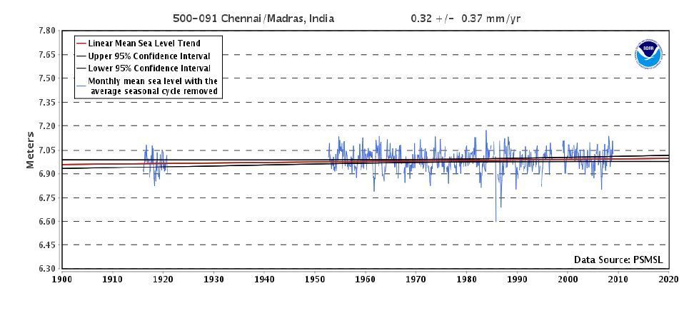
[28] | NOAA. Mean Sea Level Trends. 2016. Available from: https://tidesandcurrents.noaa.gov/sltrends/sltrends_global_station.htm?stnid=190-091 |
[29] |
Turner BL, Kasperson RE, Matson PA, et al. (2003) A framework for vulnerability analysis in sustainability science. Proc Natl Acad Sci U S A 100: 8074-8079. doi: 10.1073/pnas.1231335100
![]() |
[30] |
Turner WR, Brandon K, Brooks TM, et al. (2007) Global conservation of biodiversity and ecosystem services. BioScience 57: 868-873. doi: 10.1641/B571009
![]() |
[31] | IPCC. Emergent Risks and Key Vulnerabilities. 2012. Available from: http://ipcc-wg2.gov/AR5/images/uploads/WGIIAR5-Chap19_FINAL.pdf |
[32] |
Ramos MC, Martínez-Casasnovas JA (2009) Impacts of annual precipitation extremes on soil and nutrient losses in vineyards of NE Spain. Hydrol Process 23: 224-235. doi: 10.1002/hyp.7130
![]() |
[33] |
Segura C, Sun G, McNulty S, et al. (2014) Potential impacts of climate change on soil erosion vulnerability across the conterminous United States. J Soil Water Conserv 69: 171-181. doi: 10.2489/jswc.69.2.171
![]() |
[34] | Ramachandran A, Praveen D, Radhapriya P, et al. (2016) Vulnerability and adaptation assessment a way forward for sustainable sectoral development in the purview of climate variability and change: Insights from the coast of Tamil Nadu, India. Int J Glob Warm in press. |
[35] |
Ramachandran A, Radhapriya P, Jayakumar S, et al. (2016) Critical Analysis of Forest Degradation in the Southern Eastern Ghats of India: Comparison of Satellite Imagery and Soil Quality Index. PLoS One 11: e0147541. doi: 10.1371/journal.pone.0147541
![]() |
1. | Trinath Biswal, 2021, chapter 1, 9781799844808, 1, 10.4018/978-1-7998-4480-8.ch001 | |
2. | Trinath Biswal, 2022, chapter 60, 9781668436868, 1229, 10.4018/978-1-6684-3686-8.ch060 | |
3. | Osuagwu C. Charles, Ani D. Chinedu, Assessing the Nexus Between Landscape Degradation and Flooding in the Niger River Catchment, Southeastern Nigeria: A 40‐Year Geospatial Dynamics (1992–2022), 2024, 1085-3278, 10.1002/ldr.5311 | |
4. | P. Dhanya, R. Jagannathan, Sesha Srinivas Jonnalagadda, 2024, Chapter 2, 978-981-97-8362-5, 21, 10.1007/978-981-97-8363-2_2 |
Type of the climate | Values of DMI |
Dry | DMI < 10 |
Semi-arid-dry | 10 ≤ DMI ≤ 20 |
Mediterranean | 20 ≤ DMI < 24 |
Semi-humid | 24 ≤ DMI < 28 |
Humid | 28 ≤ DMI < 35 |
Very humid | a. 35 ≤ DMI ≤ 55 b. DMI > 55 |