Citation: M. Weremeichik Jeremy. An Obstructed Cave Passage in the Cobleskill Plateau: A Gravimetric Study[J]. AIMS Geosciences, 2015, 1(1): 80-98. doi: 10.3934/geosci.2015.1.80

| [1] | Kastning EH (1975) Cavern development in the Helderberg Plateau, east-central New York. University of Connecticut..reprinted as New York Cave Survey Bulletin 1: 194. |
| [2] | Palmer MV (1976) Groundwater flow patterns in limestone solution conduits.State University of New York at Oneonta 150. |
| [3] | Mylroie JE (1977) Speleogenesis and karst geomorphology of the Helderberg Plateau, Schoharie County, New York. Rensselaer Polytechnic Institute.reprinted as New York Cave Survey Bulletin 2: 336. |
| [4] | Dumont KA (1995) Karst hydrology and geomorphology of the Barrack Zourie Cave System, Schoharie County, New York. Mississippi State University.reprinted as New York Cave Survey Bulletin 5: 70. |
| [5] | Weremeichik JM, Mylroie JE (2014) Glacial Lake Schoharie: An investigative study of glaciolacustrine lithofacies in caves, Helderberg Plateau, central New York.J Cave Karst Stud 76: 127-138. |
| [6] | Cooper MP, Mylroie JE (2015) Glaciation and Speleogenesis: Interpretations from the Northeastern United States.Springer . |
| [7] | Palmer AN, Rubin PA, Palmer MV, et al. (2003) Karst of the Schoharie Valley and land use analysis, Schoharie County, New York State. In: Johnson EL, editor.New York State Geological Association Field Trip Guidebook 75th Annual Meeting 141-165. |
| [8] | Lauritzen S-E, Mylroie JE (2000) Results of a speleothem U/Th dating reconnaissance from the Helderberg Plateau, New York.J Cave Karst Stud 62: 20-26. |
| [9] | Rubin PA (2009) Geological evolution of the Cobleskill Plateau; New York State, USA. In.Proceedings of the 15th International Congress of Speleology 972-978. |
| [10] | Egemeier SJ (1969) Origin of caves in eastern New York as related to unconfined groundwater flow.Natl Speleol Soc Bull 37: 97-110. |
| [11] | Palmer AN, Palmer MV, Porter CO, et al. (1991) A geologic guide to the karst and caves of the Helderberg Mountains, Schoharie and Albany Counties, New York. In: Nardacci M, editor. Guide to the Caves and Karst of the Northeast: 50th Anniversary NSS Convention; Cobleskill, NY.National Speleological Society 105-167. |
| [12] | Palmer AN, Rubin PA (2007) Karst of the Silurian-Devonian Carbonates in Eastern New York State, with emphasis on the Cobleskill Plateau. In.Carbonate Geology of the Howes Cave Area, Schoharie County, New York, Hudson-Mohawk Professional Geologists Association Field Trip Guidebook 17-35. |
| [13] | Flora DF, Ferwerda JA, Ackerson KT, et al. (1969) Soil survey of Schoharie County, New York.Soil Surv Reports United States Dep Agric 153. |
| [14] | Web Soil SurveyNational Cooperative Soil Survey. U.S. Department of Agriculture.Available from . |
| [15] | Bugliosi EF, Trudell R.A, Casey GD (1988) Potential yields of wells in unconsolidated aquifers in upstate New York - Hudson-Mohawk sheet. U.S..Geological Survey Water-Resources Investigations Report 87-4275. |
| [16] | Parasnis DS (1979) Principles of applied geophysics.Chapman and Hall . |
| [17] | Torge W (1989) Gravimetry.De Gruyter . |
| [18] | Whitelaw JL, Mickus K, Whitelaw MJ, et al. (2008) High-resolution gravity study of the Gray Fossil Site.Geophysics 73: B25-B32. |
| [19] | Crawford NC, Lewis MA, Winter SA, et al. (1999) Microgravity techniques for subsurface investigations of sinkhole collapses and for detection of groundwater flow paths through karst aquifers. In: Beck BF, Pettit AJ, Herring JG, editors.Hydrology and Engineering Geology of Sinkholes and Karst 203-218. |
| [20] | Crawford NC, Webster JW, Winter SA (1989) Detection of caves from the surface by microgravity followed by exploratory drilling: Lost River Groundwater Basin, Bowling Green, Kentucky.Prepared for the City of Bowling Green, Municipal Order No 85-83. |
| [21] | Milunich K, Palmer AN (1996) Gravity survey of a buried pre-glacial valley in east-central New York and interpretation of glacial effects on karst drainage.The Compass 74: 7-13. |
| [22] | Hammer S (1939) Terrain corrections for gravimeter stations.Geophysics 4: 184-194. |
| [23] | Leaman DE (1998) The gravity terrain correction - practical considerations.Explor Geophys 29: 467-471. |
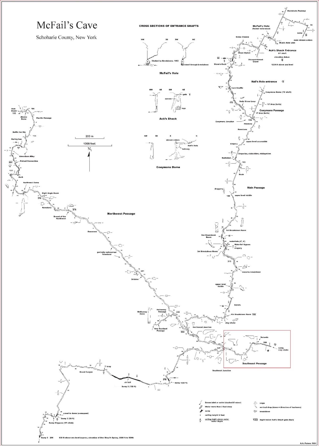
| [24] | Palmer AN (1991) Map of McFails Cave, Schoharie County, New York. In: Nardacci M, editor. Guide to the Caves and Karst of the Northeast: 50th Anniversary NSS Convention, Cobleskill, New York.National Speleological Society 167. |
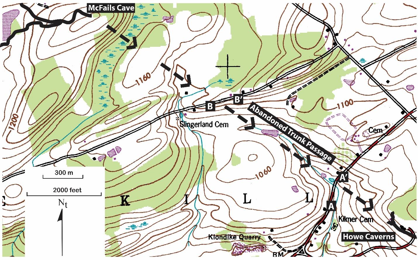
| [25] | US GS (1994) Cobleskill quadrangle, New York-Schoharie Co.: 7.5 Minute Series (Topographic).scale . |
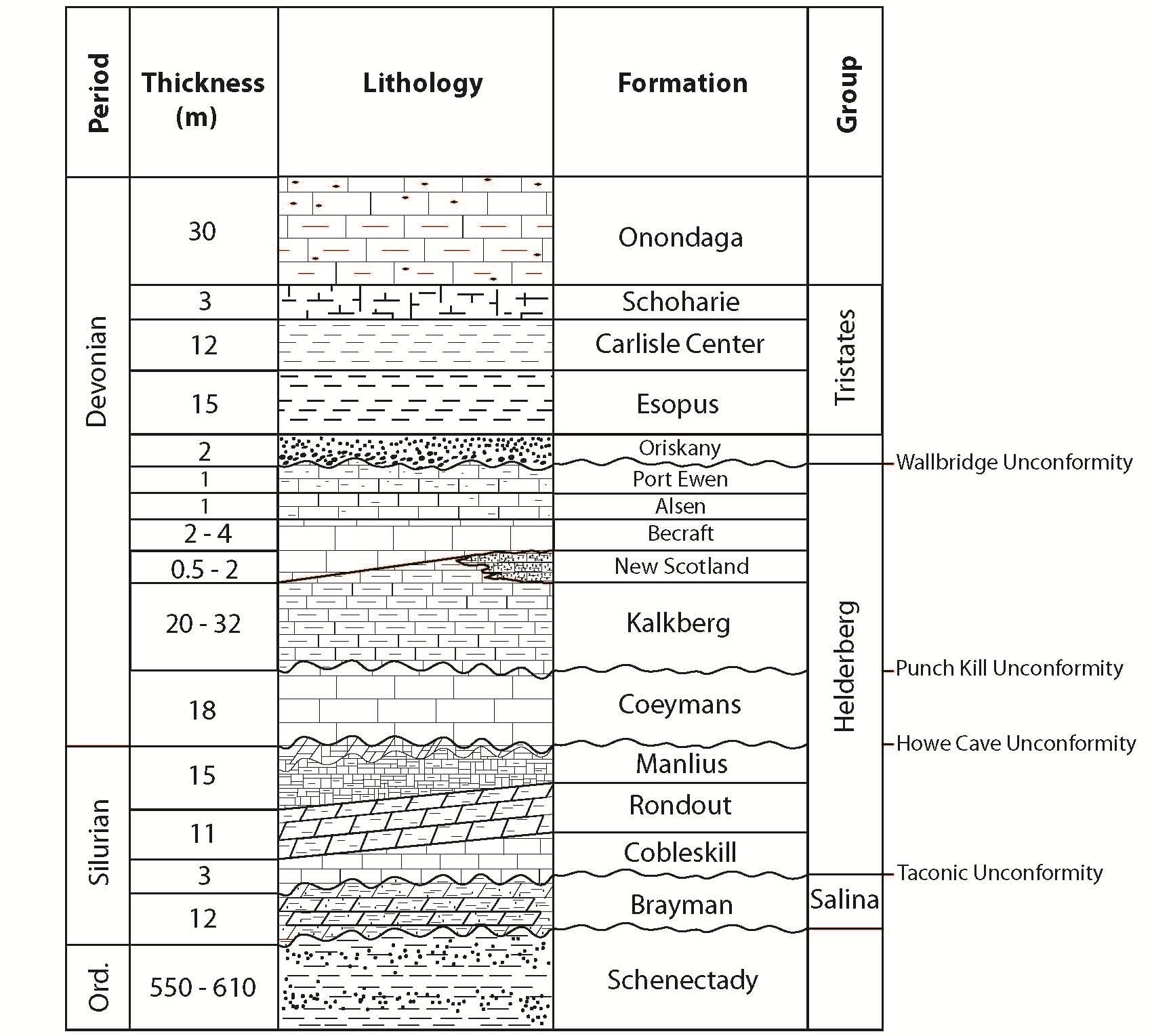
| [26] | Rickard LV (1962) Late Cayugan (Upper Silurian) and Helderbergian (Lower Devonian) stratigraphy in New York.New York State Museum and Science Service Bull 386: 157. |
| [27] | Ebert JR, Matteson DK, Natel EM (2001) Parting the Helderberg Sea: cryptic unconformities and the Silurian-Devonian boundary in the classic epeiric sea sequence of New York. In.Geologic Society of America, Abstracts and Programs 321-322. |
| [28] | Ebert JR, Matteson DK, Wilson R (2010) Sedimentologic observation and stratigraphic interpretation of the Lower Devonian (Lochkovian) Manlius Formation along the Mohawk River Valley in Upstate New York: A discussion.J Geol 118: 333-337. |
| [29] | Ver Straeten CA (2008) Volcanic tephra bed formation and condensation processes: A review and examination from Devonian stratigraphic sequences.J Geol 116: 545-557. |
| [30] | Ver Straeten CA (2009) The classic Devonian of the Catskill Front: A foreland basin record of Acadian orogenesis. In.New York State Geological Association Field Trip Guidebook 81st Annual Meeting 7-1-7-54. |
Figures(10) / Tables(2)

M. Weremeichik Jeremy. An Obstructed Cave Passage in the Cobleskill Plateau: A Gravimetric Study[J]. AIMS Geosciences, 2015, 1(1): 80-98. doi: 10.3934/geosci.2015.1.80


 DownLoad: