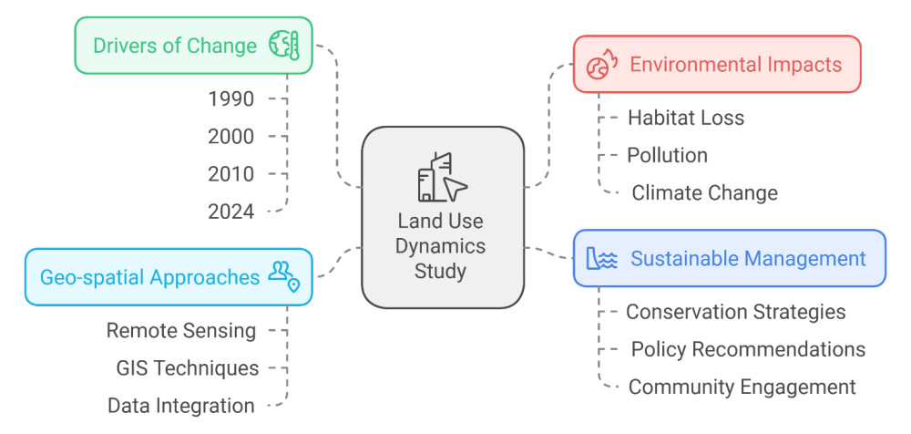
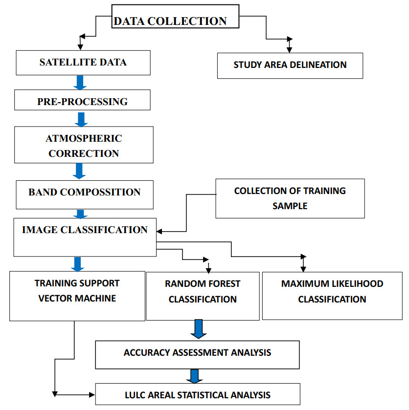
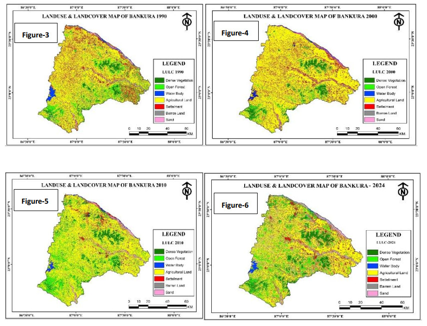
In this study, we focused on the rapid land use and land cover (LULC) changes in Bankura in 1990, 2000, 2010, and 2024, employing an integrated remote sensing, geospatial, and statistical approach to track land use changes. The supervised classification technique and change detection analysis were applied with the Supper Vector Machine (SVM), Maximum Likelihood (ML), and Random Forest (RF) methods to identify land use classes in various categories like Dense Forest, Open Forest, water body, agricultural land, settlement, barren land, and sand. The Kappa Coefficient was used for the accuracy assessment, which revealed that the overall accuracy of 1990 was 93.33%, 2000 was 93.23%, 2010 was 93.43%, and 2024 was 90%. The analysis revealed a significant increase in built-up land from agricultural and forested areas, with a higher percentage of agricultural land converted to built-up areas observed between 1990 and 2024. During this interval, the built-up land area increased by approximately 13.6%, primarily due to the conversion of agricultural land and forest cover. Agricultural land decreased by 11.45%, while dense forest cover declined by 7.75%, indicating a significant anthropogenic influence on landscape transformation. Our findings underscore the importance of sustainable land use planning, conservation efforts, and policy interventions in mitigating environmental degradation, leveraging the effectiveness of space-based inputs and geospatial techniques. The research emphasizes the need for continuous monitoring and further investigation into socio-economic drivers and environmental consequences to ensure resilient urban management and sustainable development. This reveals the importance of reforestation, preserving water bodies, and developing ecologically sensitive infrastructure. Moreover, the study highlights the importance of sustainable land use planning in mitigating adverse environmental impacts and preserving ecological balance.
Citation: Debabrata Nandi, Rakesh Ranjan Thakur, Bojan Ðurin, Mayank Pandey, Upaka Rathnayake, Dillip Kumar Bera, Roshan Beuria. Machine learning-based LULC change detection and environmental implications in Bankura, West Bengal, India[J]. AIMS Environmental Science, 2025, 12(5): 835-855. doi: 10.3934/environsci.2025037
In this study, we focused on the rapid land use and land cover (LULC) changes in Bankura in 1990, 2000, 2010, and 2024, employing an integrated remote sensing, geospatial, and statistical approach to track land use changes. The supervised classification technique and change detection analysis were applied with the Supper Vector Machine (SVM), Maximum Likelihood (ML), and Random Forest (RF) methods to identify land use classes in various categories like Dense Forest, Open Forest, water body, agricultural land, settlement, barren land, and sand. The Kappa Coefficient was used for the accuracy assessment, which revealed that the overall accuracy of 1990 was 93.33%, 2000 was 93.23%, 2010 was 93.43%, and 2024 was 90%. The analysis revealed a significant increase in built-up land from agricultural and forested areas, with a higher percentage of agricultural land converted to built-up areas observed between 1990 and 2024. During this interval, the built-up land area increased by approximately 13.6%, primarily due to the conversion of agricultural land and forest cover. Agricultural land decreased by 11.45%, while dense forest cover declined by 7.75%, indicating a significant anthropogenic influence on landscape transformation. Our findings underscore the importance of sustainable land use planning, conservation efforts, and policy interventions in mitigating environmental degradation, leveraging the effectiveness of space-based inputs and geospatial techniques. The research emphasizes the need for continuous monitoring and further investigation into socio-economic drivers and environmental consequences to ensure resilient urban management and sustainable development. This reveals the importance of reforestation, preserving water bodies, and developing ecologically sensitive infrastructure. Moreover, the study highlights the importance of sustainable land use planning in mitigating adverse environmental impacts and preserving ecological balance.

| [1] |
Ruigar H, Emamgholizadeh S, Gharechelou S, et al. (2024) Evaluating the impacts of anthropogenic, climate, and land use changes on streamflow. J Water Clim Chang 15: 1885–1905. https://doi.org/10.21203/rs.3.rs-3139611/v1. doi: 10.21203/rs.3.rs-3139611/v1

|
| [2] |
Steenwerth K L, Hodson A K, Bloom A J, et al. (2014) Climate-smart agriculture global research agenda: scientific basis for action. Agr Food Secur 3: 11. https://doi.org/10.1186/2048-7010-3-11. doi: 10.1186/2048-7010-3-11
|
| [3] |
Chatterjee B, Malakar K D (2023) Changes in Land Use Pattern and Policies: A Study of Bankura District in West Bengal, India. Asian J Geo Res 6: 89–103. https://doi.org/10.9734/ajgr/2023/v6i3192. doi: 10.9734/ajgr/2023/v6i3192
|
| [4] |
Dwivedi Y K, Hughes L, Kar A K, et al. (2022) Climate change and COP26: Are digital technologies and information management part of the problem or the solution? An editorial reflection and call to action. Int J Inform Manage 63: 102456. https://doi.org/10.1016/j.ijinfomgt.2021.102456. doi: 10.1016/j.ijinfomgt.2021.102456
|
| [5] |
Steenwerth K L, Hodson A K, Bloom A J, et al. (2014) Climate-smart agriculture global research agenda: scientific basis for action. Agr Food Secur 3: 11 https://doi.org/10.1186/2048-7010-3-11. doi: 10.1186/2048-7010-3-11
|
| [6] | Kundzewicz Z W, Kanae S, Seneviratne S I, et al. (2014) Flood risk and climate change: global and regional perspectives. Hydrol Sci J 59: 1–28. |
| [7] |
Hall O (2010) Remote sensing in social science research. Open Remote Sens J 3: 1–16. https://doi.org/10.2174/1875413901003010001. doi: 10.2174/1875413901003010001
|
| [8] |
Lu D, Mausel P, Brondizio E, et al. (2004) Change detection techniques. Int J Remote Sens 25: 2365–2401. https://doi.org/10.1080/0143116031000139863. doi: 10.1080/0143116031000139863
|
| [9] |
Burkhard B, Kroll F, Müller F, et al. (2009) Landscapes' capacities to provide ecosystem services-A concept for land-cover based assessments. Landscape Online 2009: 15–15. https://doi.org/10.3097/lo.200915. doi: 10.3097/lo.200915
|
| [10] |
Verburg P H, Schot P P, Dijst M J, et al. (2004) Land use change modelling: current practice and research priorities. Geo J 61: 309–324. https://doi.org/10.1007/s10708-004-4946-y. doi: 10.1007/s10708-004-4946-y
|
| [11] |
Johnston S G, Slavich P G, Hirst P (2005) Changes in surface water quality after inundation of acid sulfate soils of different vegetation cover. Soil Res 43: 1–12. https://doi.org/10.1071/sr04073. doi: 10.1071/sr04073
|
| [12] |
Allen C D, Macalady A K, Chenchouni H, et al. (2010) A global overview of drought and heat-induced tree mortality reveals emerging climate change risks for forests. Forest Ecol Manag 259: 660–684. https://doi.org/10.1016/j.foreco.2009.09.001. doi: 10.1016/j.foreco.2009.09.001
|
| [13] |
Weng Q (2009) Thermal infrared remote sensing for urban climate and environmental studies: Methods, applications, and trends. ISPRS J Photogramm Remote Sens 64: 335–344. https://doi.org/10.1016/j.isprsjprs.2009.03.007. doi: 10.1016/j.isprsjprs.2009.03.007
|
| [14] |
Poff N L, Richter B D, Arthington A H, et al. (2010) The ecological limits of hydrologic alteration (ELOHA): a new framework for developing regional environmental flow standards. Freshwater Biol 55: 147–170. https://doi.org/10.1111/j.1365-2427.2009.02204.x. doi: 10.1111/j.1365-2427.2009.02204.x
|
| [15] | Saikia J, Shah R K, Buragohain P P, et al. (2024) An interactive study between the Poba Reserve Forest and the Brahmaputra River of Assam using geo-spatial technology. P Indian Natl Sci Ac 90: 48–54. |
| [16] |
O'Neill B C, Kriegler E, Riahi K, et al. (2014) A new scenario framework for climate change research: the concept of shared socioeconomic pathways. Clim Change 122: 387–400. https://doi.org/10.1007/s10584-013-0905-2. doi: 10.1007/s10584-013-0905-2
|
| [17] |
Sousedik C, Busch C (2014) Presentation attack detection methods for fingerprint recognition systems: a survey. Iet Biom 3: 219–233. https://doi.org/10.1049/iet-bmt.2013.0020. doi: 10.1049/iet-bmt.2013.0020
|
| [18] |
Rogan J, Chen D M (2004) Remote sensing technology for mapping and monitoring land-cover and land-use change. Prog Plann 61: 301–325. https://doi.org/10.1016/s0305-9006(03)00066-7. doi: 10.1016/s0305-9006(03)00066-7
|
| [19] | Steffen W, Crutzen P J, McNeill J R (2007) The Anthropocene: are humans now overwhelming the great forces of nature. Ambio-J Human Environ Res Manage 36: 614–621. |
| [20] | Baker C, Lawrence R L, Montagne C, et al. (2007) Change detection of wetland ecosystems using Landsat imagery and change vector analysis. Wetlands 27: 610–619. |
| [21] | Coulon M, Tourneret J Y (2020) Bayesian change detection for multi-temporal SAR images. IEEE International Conference on Acoustics Speech and Signal Processing Ⅱ-Ⅱ. |
| [22] | de Vries, Petrus (2024) Autism Research Is Becoming More Diverse but Not yet More Global. The Transmitter, Simons Foundation https://doi.org/10.53053/yncz6438. |
| [23] | Jamaat A, Safaie A (2021) Detection of Land Use-Land Cover Changes in Anzali Wetland Using a Remote Sensing-Based Approach. https://doi.org/10.5194/egusphere-egu21-12119. |
| [24] | Ricchetti E, Ricchetti G, Sani R (2004) Environmental-Geological Study of Coastal Areas of Salento Peninsula (Southern Italy) Using Multitemporal Aerial Photography and Satellite Imagery. IEEE International IEEE International IEEE International Geoscience and Remote Sensing Symposium, 2004. IGARSS '04. Proceedings. IEEE, 2004. https://doi.org/10.1109/igarss.2004.1369908. |
| [25] |
Hasse J E, Lathrop R G (2003) Land resource impact indicators of urban sprawl. Appl Geogr 23: 159–175. https://doi.org/10.1016/j.apgeog.2003.08.002. doi: 10.1016/j.apgeog.2003.08.002
|
| [26] |
Torgesen J K, Wagner R K, Rashotte C A (1994) Longitudinal studies of phonological processing and reading. J Learn Disabil 27: 276–286. https://doi.org/10.1177/002221949402700503. doi: 10.1177/002221949402700503
|
| [27] |
De Groot R S, Alkemade R, Braat L, et al. (2010) Challenges in integrating the concept of ecosystem services and values in landscape planning, management and decision-making. Ecol Complex 7: 260–272. https://doi.org/10.1016/j.ecocom.2009.10.006. doi: 10.1016/j.ecocom.2009.10.006
|
| [28] |
Turner B L, Lambin E F, Reenberg A (2007) The emergence of land change science for global environmental change and sustainability. P Natl A Sci 104: 20666–20671. https://doi.org/10.1073/pnas.0704119104. doi: 10.1073/pnas.0704119104
|
| [29] |
Scaioni M, Longoni L, Melillo V, et al. (2014) Remote sensing for landslide investigations: An overview of recent achievements and perspectives. Remote Sens 6: 9600–9652. https://doi.org/10.3390/rs6109600. doi: 10.3390/rs6109600
|
| [30] |
Zhong K W, Sun C G, Jie L (2009) The dynamic monitoring of land use change in Guangzhou based on RS and GIS. J Geo⁃ Information Sci 11: 111–116. https://doi.org/10.3724/sp.j.1047.2009.00111. doi: 10.3724/sp.j.1047.2009.00111
|
| [31] |
Haslauer E, Biberacher M, Blaschke T (2016) A spatially explicit backcasting approach for sustainable land-use planning. J Environ Plan Man 59: 866–890. https://doi.org/10.1080/09640568.2015.1044652. doi: 10.1080/09640568.2015.1044652
|
| [32] | Brekke LD, Kiang J E, Olsen JR, et al. Climate Change and Water Resources Management: A Federal Perspective. Circular, US Geological Survey, 2009. https://doi.org/10.3133/cir1331. |
| [33] |
Zhang M, Chen E, Zhang C, et al. (2024). Multi-scenario simulation of land use change and ecosystem service value based on the markov–FLUS model in Ezhou city, China. Sustainability 16: 6237. https://doi.org/10.3390/su16146237. doi: 10.3390/su16146237
|
| [34] |
Lu Z, Zhang M, Hu C, et al. (2024) Spatiotemporal changes and influencing factors of the coupled production–Living–Ecological functions in the Yellow River Basin, China. Land 13: 1909. https://doi.org/10.3390/land13111909. doi: 10.3390/land13111909
|
| [35] |
Wang Z, Jiang S, Xu S, et al. (2024) Spatial patterns and its influencing factors on villages around the Ji-shape bend of the Yellow River. Front Environ Sci 12: 1477693. https://doi.org/10.3389/fenvs.2024.1477693. doi: 10.3389/fenvs.2024.1477693
|
| [36] |
Zhang M, Tan S, Liang J, et al. (2024) Predicting the impacts of urban development on urban thermal environment using machine learning algorithms in Nanjing, China. J Environ Manage 356: 120560. https://doi.org/10.1016/j.jenvman.2024.120560. doi: 10.1016/j.jenvman.2024.120560
|
| [37] | Reyes, P., & Landicho, M Digitalizing H2O: Digitalizing for Water Security and Resilience in Asia and the Pacific. Asian Development Bank, 1 Mar. 2022. https://doi.org/10.22617/arm220062-2. |
| [38] |
De Groot R S, Alkemade R, Braat L, et al. (2010) Challenges in integrating the concept of ecosystem services and values in landscape planning, management and decision making. Ecol Complex 7: 260–272. https://doi.org/10.1016/j.ecocom.2009.10.006. doi: 10.1016/j.ecocom.2009.10.006
|
| [39] |
Nesshöver C, Assmuth T, Irvine K N, et al. (2017) The science, policy and practice of nature-based solutions: An interdisciplinary perspective. Sci Total Environ 579: 1215–1227. https://doi.org/10.1016/j.scitotenv.2016.11.106. doi: 10.1016/j.scitotenv.2016.11.106
|
| [40] |
Hassan Z, Shabbir R, Ahmad S S, et al. (2016) Dynamics of land use and land cover change (LULCC) using geospatial techniques: a case study of Islamabad Pakistan. Springer Plus 5: 812. https://doi.org/10.1186/s40064-016-2414-z doi: 10.1186/s40064-016-2414-z
|
| [41] |
Glotfelty T, Ramírez-Mejía D, Bowden J, et al. (2021) Limitations of WRF land surface models for simulating land use and land cover change in Sub-Saharan Africa and development of an improved model (CLM-AF v. 1.0). Geosci Model Dev 14: 3215–3249. https://doi.org/10.5194/gmd-14-3215-2021. doi: 10.5194/gmd-14-3215-2021
|
| [42] |
Zhang Y, Carballo A, Yang H, et al. (2023) Perception and sensing for autonomous vehicles under adverse weather conditions: A survey. ISPRS J Photogramm Remote Sens 196: 146–177. https://doi.org/10.1016/j.isprsjprs.2022.12.021. doi: 10.1016/j.isprsjprs.2022.12.021
|
| [43] |
Li Z L, Wu H, Duan S B, et al. (2023) Satellite remote sensing of global land surface temperature: Definition, methods, products, and applications. Rev Geophys 61. https://doi.org/10.1029/2022rg000777. doi: 10.1029/2022rg000777
|
| [44] |
Mohammed G H, Colombo R, Middleton E M, et al. (2019) Remote sensing of solar-induced chlorophyll fluorescence (SIF) in vegetation: 50 years of progress. Remote Sens Environ 231: 111177. https://doi.org/10.1016/j.rse.2019.04.030. doi: 10.1016/j.rse.2019.04.030
|
| [45] |
Mercado L M, Bellouin N, Sitch S, et al. (2009) Impact of changes in diffuse radiation on the global land carbon sink. Nature 458: 1014–1017.https://doi.org/10.1038/nature07949 doi: 10.1038/nature07949
|
| [46] |
Sowmya D R, Shenoy P D, Venugopal K R (2017) Remote sensing satellite image processing techniques for image classification: a comprehensive survey. Int J Comput Appl 161: 24–37. https://doi.org/10.5120/ijca2017913306. doi: 10.5120/ijca2017913306
|
| [47] |
Bioucas-Dias J M, Plaza A, Dobigeon N, et al. (2012) Hyperspectral unmixing overview: Geometrical, statistical, and sparse regression-based approaches. IEEE J Sel Top Appl Earth Observ Remote Sens 5: 354–379. https://doi.org/10.1109/jstars.2012.2194696. doi: 10.1109/jstars.2012.2194696
|
| [48] |
Hadjimitsis D G, Clayton C R I (2008) The use of an improved atmospheric correction algorithm for removing atmospheric effects from remotely sensed images using an atmosphere–surface simulation and meteorological data. Meteorol Appl 15: 381–387. https://doi.org/10.1002/met.80. doi: 10.1002/met.80
|
| [49] |
Jain P K, Lee K S, El-Sayed I H, et al. (2006) Calculated absorption and scattering properties of gold nanoparticles of different size, shape, and composition: applications in biological imaging and biomedicine. J Phys Chem 110: 7238–7248. https://doi.org/10.1021/jp057170o. doi: 10.1021/jp057170o
|
| [50] |
Bioucas-Dias J M, Plaza A, Camps-Valls G, et al. (2013) Hyperspectral remote sensing data analysis and future challenges. IEEE Geosci Remote Sens Mag 1: 6–36. https://doi.org/10.1109/mgrs.2013.2244672. doi: 10.1109/mgrs.2013.2244672
|
| [51] | Li P, Wang Y, Tao X (2013) Semi-Supervised Network Traffic Classification Method Based on Support Vector Machine. Journal of Computer Applications China Science Publishing & Media Ltd., 33: 1515–1518. https://doi.org/10.3724/sp.j.1087.2013.01515. |
| [52] |
Güler M, Yomralıoğlu T, Reis S (2007) Using landsat data to determine land use/land cover changes in Samsun, Turkey. Environ Monit Assess 127: 155–167. https://doi.org/10.1007/s10661-006-9270-1 doi: 10.1007/s10661-006-9270-1
|
| [53] |
Nik-Zainal S, Davies H, Staaf J, et al. (2016) Landscape of somatic mutations in 560 breast cancer whole-genome sequences. Nature 534: 47–54. https://doi.org/10.1038/nature17676. doi: 10.1038/nature17676
|
| [54] | Paskevich V F. Conversion of raster image data to vector cartographic data. US Geological Survey, 1991. https://doi.org/10.3133/ofr91304. |
| [55] | Devaki M, Jayanthi K B (2023) Water Body Change Detection and Estimation From Landsat Satellite Images Using Deep Learning. 2023 https://doi.org/10.21203/rs.3.rs-2833110/v1 |
| [56] | Fedoseev, O. N (2024) Calculation of the Coverage Area Based on GOOGLE EARTH Satellite Images (MAP PIXEL-Decryption V1.1). Ailamazyan Program Systems Institute of Russian Academy of Sciences, 30 Jan. 2024. https://doi.org/10.12731/ofernio.2023.25277. |
| [57] |
Mkumbo N J, Mussa K R, Mariki E E, et al. (2022) The Use of the DRASTIC-LU/LC model for assessing groundwater vulnerability to nitrate contamination in Morogoro Municipality, Tanzania. Earth 3: 1161–1184. https://doi.org/10.3390/earth3040067. doi: 10.3390/earth3040067
|
| [58] |
Alberti M, Asbjornsen H, Baker L A, et al. (2011) Research on coupled human and natural systems (CHANS): approach, challenges, and strategies. Bull Ecol Soc Am 92: 218–228 https://doi.org/10.1890/0012-9623-92.2.218. doi: 10.1890/0012-9623-92.2.218
|
| [59] |
Gashaye D, Woldu Z, Nemomissa S, et al. (2023) The land-use and land-cover changes in the este district, south gondar zone, northwestern Ethiopia, in the last four decades (the 1980s to 2020s). Land 12: 1655. https://doi.org/10.3390/land12091655. doi: 10.3390/land12091655
|
| [60] |
Villa A, Benediktsson J A, Chanussot J, et al. (2011) Hyperspectral image classification with independent component discriminant analysis. IEEE T Geosci Remote 49: 4865–4876. https://doi.org/10.1109/tgrs.2011.2153861. doi: 10.1109/tgrs.2011.2153861
|
| [61] |
Singh S K, Mustak S, Srivastava P K, et al. (2015) Predicting spatial and decadal LULC changes through cellular automata Markov chain models using earth observation datasets and geo-information. Environ Process 2: 61–78. https://doi.org/10.1007/s40710-015-0062-x. doi: 10.1007/s40710-015-0062-x
|
| [62] | Kalson, Pranshu (2023) A Study on Land Use and Land Cover Change (LULC) Dynamics in Haryana'. SK International Journal of Multidisciplinary Research Hub, vol. 10, no. 9, SK Publisher, Sept. 2023, pp. 37–43. https://doi.org/10.61165/sk.publisher.v10i9.8. |
| [63] |
Jain M, Dawa D, Mehta R, et al. (2016) Monitoring land use change and its drivers in Delhi, India using multi-temporal satellite data. Model Earth Syst Environ 2: 19. https://doi.org/10.1007/s40808-016-0075-0. doi: 10.1007/s40808-016-0075-0
|
| [64] |
Wulder M A, Loveland T R, Roy D P, et al. (2019) Current status of Landsat program, science, and applications. Remote Sens Environ 225: 127–147. https://doi.org/10.1016/j.rse.2019.02.015. doi: 10.1016/j.rse.2019.02.015
|
| [65] |
Braat L C, De Groot R (2012) The ecosystem services agenda: bridging the worlds of natural science and economics, conservation and development, and public and private policy. Ecosyst Serv 1: 4–15. https://doi.org/10.1016/j.ecoser.2012.07.011. doi: 10.1016/j.ecoser.2012.07.011
|
| [66] | Ariffin R N R, Rahman N H A, Zahari R K (2021) Systematic literature review of walkability and the build environment. J. Pol'y & Governance 1: 1. https://doi.org/10.33002/jpg010101. |
| [67] |
Moss R H, Edmonds J A, Hibbard K A, et al. (2010) The next generation of scenarios for climate change research and assessment. Nature 463: 747–756. https://doi.org/10.1038/nature08823. doi: 10.1038/nature08823
|
| [68] |
Weiss M, Jacob F, Duveiller G (2020) Remote sensing for agricultural applications: A meta-review. Remote Sens Environ 236: 111402. https://doi.org/10.1016/j.rse.2019.111402. doi: 10.1016/j.rse.2019.111402
|
| [69] |
Engel S, Pagiola S, Wunder S (2008) Designing payments for environmental services in theory and practice: An overview of the issues. Ecol Econ 65: 663–674. https://doi.org/10.1016/j.ecolecon.2008.03.011. doi: 10.1016/j.ecolecon.2008.03.011
|
| [70] | Kabisch N, Korn H, Stadler J, et al. (2017) Nature-based solutions to climate change adaptation in urban areas: Linkages between science, policy and practice[M]. Springer Nature, 2017. |
| [71] |
De Groot R S, Alkemade R, Braat L, et al. (2010) Challenges in integrating the concept of ecosystem services and values in landscape planning, management and decision making. Ecol Complex 7: 260–272. https://doi.org/10.1016/j.ecocom.2009.10.006. doi: 10.1016/j.ecocom.2009.10.006
|
| [72] | Steffen W, Tyson P (2004) Global Change and the Earth System: A Planet under Pressure'. Choice (Chicago, Ill.), vol. 42, no. 03, American Library Association, Nov. 2004, pp. 42-1542-42–1542. https://doi.org/10.5860/choice.42-1542. |
| [73] |
Raihan A, Rashid M, Voumik L C, et al. (2023) The dynamic impacts of economic growth, financial globalization, fossil fuel, renewable energy, and urbanization on load capacity factor in Mexico. Sustainability 15: 13462. https://doi.org/10.3390/su151813462. doi: 10.3390/su151813462
|
| [74] |
Lambin E F, Turner B L, Geist H J, et al. (2001) The causes of land-use and land-cover change: moving beyond the myths. Global Environ Chang 11: 261–269. https://doi.org/10.1016/S0959-3780(01)00007-3. doi: 10.1016/S0959-3780(01)00007-3
|
| [75] |
Turner W R, Brandon K, Brooks T M, et al. (2007) Global conservation of biodiversity and ecosystem services. BioScience 57: 868–873. https://doi.org/10.1641/B571009. doi: 10.1641/B571009
|
| [76] | Majumder S, Patra A, Kar S, et al. (2016) Micro-faunal distribution with effective variation of physico-chemical parameters in two different zones of freshwater ecosystem in Bankura district of WB, India. Int J Adv Res 4: 473–487. |
| [77] | Surajit Majumder S M, Patra Monoj P M, Banerjee Sulogna B S, et al. (2019) A study of plankton diversity of some ponds of Bankura town, West Bengal, India. 2019. |
| [78] |
Costanza R, De Groot R, Sutton P, et al. (2014) Changes in the global value of ecosystem services. Global Environ Chang 26: 152–158. https://doi.org/10.1016/j.gloenvcha.2014.04.002. doi: 10.1016/j.gloenvcha.2014.04.002
|
| [79] | McDonald R I, Marcotullio P J, Güneralp B (2013) Urbanization and global trends in biodiversity and ecosystem services[M]//Urbanization, biodiversity and ecosystem services: challenges and opportunities: a global assessment. Dordrecht: Springer Netherlands 2013: 31–52. https://doi.org/10.1007/978-94-007-7088-1_3. |
| [80] | Wood S, Sebastian K, Chamberlin J (2003) Land quality, agricultural productivity, and food security: a spatial perspective[M]//Land Quality, Agricultural Productivity, and Food Security. Edward Elgar Publishing, 2003: 47–110. https://doi.org/10.4337/9781781956977.00010. |
| [81] |
Gann G D, McDonald T, Walder B, et al. (2019) International principles and standards for the practice of ecological restoration. Restoration Ecology 27: S1–S46. https://doi.org/10.1111/rec.13035. doi: 10.1111/rec.13035
|
| [82] | Duran E, Mas J F, Velázquez A (2005) Chapter 10: Land Use/Cover Change in Community-Based Forest Management Regions and Protected Areas in Mexico[M]//The community forests of Mexico: managing for sustainable landscapes. University of Texas Press, 2005: 215–238. https://doi.org/10.7560/706378-012. |
| [83] | Kumar S N (2013) Modelling climate change impacts, adaptation strategies and mitigation potential in horticultural crops[M]//Climate-Resilient Horticulture: Adaptation and Mitigation Strategies. India: Springer India 2013: 21–33. https://doi.org/10.1007/978-81-322-0974-4_3. |
| [84] |
Steenwerth K L, Hodson A K, Bloom A J, et al. (2014) Climate-smart agriculture global research agenda: scientific basis for action. Agr Food Secur 3: 11. https://doi.org/10.1186/2048-7010-3-11. doi: 10.1186/2048-7010-3-11
|
| [85] |
Zones G E (2019) Determinants of Coping Strategies to Floods and Droughts in Multiple. Nat Hazards Risk Expos Response Resilience 2019: 163. https://doi.org/10.5772/intechopen.84571. doi: 10.5772/intechopen.84571
|
| [86] |
Koroso N H, Lengoiboni M, Zevenbergen J A (2021) Urbanization and urban land use efficiency: Evidence from regional and Addis Ababa satellite cities, Ethiopia. Habitat Int 117: 102437. https://doi.org/10.1016/j.habitatint.2021.102437. doi: 10.1016/j.habitatint.2021.102437
|
| [87] | Lee S J, Lee Y W (2020) Estimation of Soil Moisture Content Using Deep Learning and High-Resolution Satellite Imagery (Sentinel-1 and 2)[C]//EGU General Assembly Conference Abstracts. 2020: 21049. https://doi.org/10.5194/egusphere-egu2020-21049. |
| [88] | Sutradhar, Subhasish, and Prolay Mondal (2023) GIS Based Groundwater Quality Assessment and Pollution Index of Bankura District, West Bengal, India. Peeref, 29 Nov. 2023. https://doi.org/10.54985/peeref.2311p4806828. |
| [89] |
Vystavna Y, Paule-Mercado M C, Schmidt S I, et al. (2023) Nutrient dynamics in temperate European catchments of different land use under changing climate. J Hydrol Reg Stud 45: 101288. https://doi.org/10.1016/j.ejrh.2022.101288. doi: 10.1016/j.ejrh.2022.101288
|
| [90] |
Raad A, White J D (2023) Socioeconomic and Climatic Drivers of Land-Cover and Land-Use Change: An Assessment with Nasa's Sedac Datasets. GIS Remote Sens Tech 2023. https://doi.org/10.2139/ssrn.4494618. doi: 10.2139/ssrn.4494618
|
| [91] | Van Dijk W F A, Lokhorst A M, Berendse F, et al. (2015) Collective agri-environment schemes: How can regional environmental cooperatives enhance farmers' intentions for agri-environment schemes? Land Use Pol 42: 759–766. |
| [92] |
Ali K, Johnson B A (2022) Land-use and land-cover classification in semi-arid areas from medium-resolution remote-sensing imagery: A deep learning approach. Sensors 22: 8750. https://doi.org/10.3390/s22228750. doi: 10.3390/s22228750
|
| [93] | Maro P (2011) Discussing Causes and Consequences of Land-Use Change in the Lowland Region[M]//Environmental Change in Lesotho: An Analysis of the Causes and Consequences of Land-Use Change in the Lowland Region. Dordrecht: Springer Netherlands, 2011: 149–177. https://doi.org/10.1007/978-94-007-1881-4_6. |
| [94] |
Ullah S, Qiao X, Abbas M (2024) Addressing the impact of land use land cover changes on land surface temperature using machine learning algorithms. Sci Rep 14: 18746. https://doi.org/10.1038/s41598-024-68492-7. doi: 10.1038/s41598-024-68492-7
|
| [95] |
Deng X, Su H, Zhan J (2008) Integration of multiple data sources to simulate the dynamics of land systems. Sensors 8: 620–634. https://doi.org/10.3390/s8020620. doi: 10.3390/s8020620
|
| [96] | Mewburn, Inger, and Simon Clews (2023) Lights, Camera, Research! Making Short Videos. Be Visible Or Vanish, Routledge 153–161. https://doi.org/10.4324/9781003197713-18. |
| [97] |
Das S, Angadi D P (2020) Land use-land cover (LULC) transformation and its relation with land surface temperature changes: A case study of Barrackpore Subdivision, West Bengal, India. Remote Sens Appl Soc Environ 19: 100322. https://doi.org/10.1016/j.rsase.2020.100322. doi: 10.1016/j.rsase.2020.100322
|
| [98] | Kumari P, Nema A K (2017) Impact of urbanization on climate change in Delhi NCR due to land use changes[C]//ASCE India Conference 2017. Reston, VA: American Society of Civil Engineers, 2017: 321–329. https://doi.org/10.1061/9780784482032.033. |
| [99] |
Michalak W Z (1993) GIS in land use change analysis: integration of remotely sensed data into GIS. Appl Geogr 13: 28–44. https://doi.org/10.1016/0143-6228(93)90078-f. doi: 10.1016/0143-6228(93)90078-f
|
| [100] | Margerum, Richard (2012) Regional Transportation and Land Use Decision Making in Metropolitan Regions: Findings from Four Case Studies. Portland State University Library, 1 Feb. 2012. https://doi.org/10.15760/trec.60. |
| [101] |
Fox J L, Nurbu C, Bhatt S, et al. (1994) Wildlife conservation and land-use changes in the Transhimalayan region of Ladakh, India. MT Res Dev 1994: 39–60. https://doi.org/10.2307/3673737. doi: 10.2307/3673737
|
| [102] |
Mariyam S, Cochrane L, Al-Ansari T, et al. (2024) A framework to support localized solid waste management decision making: Evidence from Qatar. Environ Dev 50: 100986. https://doi.org/10.1016/j.envdev.2024.100986. doi: 10.1016/j.envdev.2024.100986
|
 Environ-12-05-037 - s001.docx Environ-12-05-037 - s001.docx |
 |
| Environ-12-05-037 - s001.pdf |
|
Figures(4) / Tables(7)

Debabrata Nandi, Rakesh Ranjan Thakur, Bojan Ðurin, Mayank Pandey, Upaka Rathnayake, Dillip Kumar Bera, Roshan Beuria. Machine learning-based LULC change detection and environmental implications in Bankura, West Bengal, India[J]. AIMS Environmental Science, 2025, 12(5): 835-855. doi: 10.3934/environsci.2025037


 DownLoad: