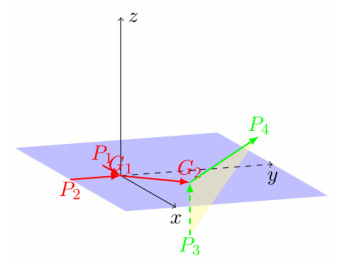
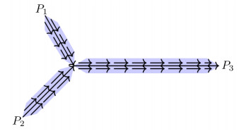
We investigate the relation between energy minimizing maps valued into spheres having topological singularities at given points and optimal networks connecting them (e.g., Steiner trees, Gilbert-Steiner irrigation networks). We show the equivalence of the corresponding variational problems, interpreting in particular the branched optimal transport problem as a homological Plateau problem for rectifiable currents with values in a suitable normed group. This generalizes the pioneering work by Brezis, Coron and Lieb [
Citation: Sisto Baldo, Van Phu Cuong Le, Annalisa Massaccesi, Giandomenico Orlandi. Energy minimizing maps with prescribed singularities and Gilbert-Steiner optimal networks[J]. Mathematics in Engineering, 2023, 5(4): 1-19. doi: 10.3934/mine.2023078
We investigate the relation between energy minimizing maps valued into spheres having topological singularities at given points and optimal networks connecting them (e.g., Steiner trees, Gilbert-Steiner irrigation networks). We show the equivalence of the corresponding variational problems, interpreting in particular the branched optimal transport problem as a homological Plateau problem for rectifiable currents with values in a suitable normed group. This generalizes the pioneering work by Brezis, Coron and Lieb [

| [1] |
S. Alama, L. Bronsard, P. Mironescu, On compound vortices in a two-component Ginzburg-Landau functional, Indiana Univ. Math. J., 61 (2012), 1861–1909. https://doi.org/10.1512/iumj.2012.61.4737 doi: 10.1512/iumj.2012.61.4737

|
| [2] |
G. Alberti, S. Baldo, G. Orlandi, Functions with prescribed singularities, J. Eur. Math. Soc., 5 (2003), 275–311. https://doi.org/10.1007/s10097-003-0053-5 doi: 10.1007/s10097-003-0053-5
|
| [3] |
G. Alberti, S. Baldo, G. Orlandi, Variational convergence for functionals of Ginzburg-Landau type, Indiana Univ. Math. J., 54 (2005), 1411–1472. https://doi.org/10.1512/iumj.2005.54.2601 doi: 10.1512/iumj.2005.54.2601
|
| [4] | F. J. Almgren, W. Browder, E. H. Lieb, Co-area, liquid crystals, and minimal surfaces, In: Partial differential equations, Berlin: Springer, 1988, 1–22. https://doi.org/10.1007/BFb0082921 |
| [5] | M. Bernot, V. Caselles, J.-M. Morel, Optimal transportation networks, Berlin: Springer, 2009. https://doi.org/10.1007/978-3-540-69315-4 |
| [6] |
M. Bonafini, G. Orlandi, É. Oudet, Variational approximation of functionals defined on $1$-dimensional connected sets: the planar case, SIAM J. Math. Anal., 50 (2018), 6307–6332. https://doi.org/10.1137/17M1159452 doi: 10.1137/17M1159452
|
| [7] |
M. Bonafini, G. Orlandi, É. Oudet, Variational approximation of functionals defined on 1-dimensional connected sets in $\Bbb R^{n}$, Adv. Calc. Var., 14 (2020), 541–553. https://doi.org/10.1515/acv-2019-0031 doi: 10.1515/acv-2019-0031
|
| [8] |
M. Bonafini, É. Oudet, A convex approach to the Gilbert–Steiner problem, Interfaces Free Bound., 22 (2020), 131–155. https://doi.org/10.4171/ifb/436 doi: 10.4171/ifb/436
|
| [9] |
M. Bonnivard, A. Lemenant, F. Santambrogio, Approximation of length minimization problems among compact connected sets, SIAM J. Math. Anal., 47 (2015), 1489–1529. https://doi.org/10.1137/14096061X doi: 10.1137/14096061X
|
| [10] | H. Brezis, J. M. Coron, E. H. Lieb, Harmonic maps with defects, Commun. Math. Phys., 107 (1986), 649–705. |
| [11] | G. Caldini, A. Marchese, S. Steinbrüchel, Generic uniqueness of optimal transportation networks, arXiv: 2205.05023. |
| [12] |
M. Carioni, A. Pluda, On different notions of calibrations for minimal partitions and minimal networks in $\Bbb R^{2}$, Adv. Calc. Var., 14 (2019), 401–417. https://doi.org/10.1515/acv-2019-0005 doi: 10.1515/acv-2019-0005
|
| [13] |
M. Colombo, A. De Rosa, A. Marchese, On the well-posedness of branched transportation, Commun. Pure Appl. Math., 74 (2021), 833–864. https://doi.org/10.1002/cpa.21919 doi: 10.1002/cpa.21919
|
| [14] |
M. Colombo, A. De Rosa, A. Marchese, P. Pegon, A. Prouff, Stability of optimal traffic plans in the irrigation problem, Discrete Contin. Dyn. Syst., 42 (2022), 1647–1667. https://doi.org/10.3934/dcds.2021167 doi: 10.3934/dcds.2021167
|
| [15] |
S. Conti, A. Garroni, A. Massaccesi, Modeling of dislocations and relaxation of functionals on 1-currents with discrete multiplicity, Calc. Var., 54 (2015), 1847–1874. https://doi.org/10.1007/s00526-015-0846-x doi: 10.1007/s00526-015-0846-x
|
| [16] | H. Federer, Geometric measure theory, New York: Springer, 1969. https://doi.org/10.1007/978-3-642-62010-2 |
| [17] |
R. Harvey, H. B. Lawson, Calibrated geometries, Acta Math., 148 (1982), 47–157. https://doi.org/10.1007/BF02392726 doi: 10.1007/BF02392726
|
| [18] |
C. P. Hopper, Partial regularity for holonomic minimisers of quasiconvex functionals, Arch. Rational Mech. Anal., 222 (2016), 91–141. https://doi.org/10.1007/s00205-016-0997-8 doi: 10.1007/s00205-016-0997-8
|
| [19] |
R. L. Jerrard, H. M. Soner, Functions of bounded higher variation, Indiana Univ. Math. J., 51 (2002), 645–677. https://doi.org/10.1512/iumj.2002.51.2229 doi: 10.1512/iumj.2002.51.2229
|
| [20] |
A. Marchese, A. Massaccesi, An optimal irrigation network with infinitely many branching points, ESAIM: COCV, 22 (2016), 543–561. https://doi.org/10.1051/cocv/2015028 doi: 10.1051/cocv/2015028
|
| [21] |
A. Marchese, A. Massaccesi, The Steiner tree problem revisited through rectifiable $G$-currents, Adv. Calc. Var., 9 (2016), 19–39. https://doi.org/10.1515/acv-2014-0022 doi: 10.1515/acv-2014-0022
|
| [22] | A. Massaccesi, Currents with coefficients in groups, applications and other problems in Geometric Measure Theory, Ph. D thesis, Scuola Normale Superiore di Pisa, 2014. |
| [23] |
A. Massaccesi, É. Oudet, B. Velichkov, Numerical calibration of Steiner trees, Appl. Math. Optim., 79 (2019), 69–86. https://doi.org/10.1007/s00245-017-9421-5 doi: 10.1007/s00245-017-9421-5
|
| [24] |
N. D. Mermin, The topological theory of defects in ordered media, Rev. Mod. Phys., 51 (1979), 591–648. https://doi.org/10.1103/RevModPhys.51.591 doi: 10.1103/RevModPhys.51.591
|
| [25] |
É. Oudet, F. Santambrogio, A Modica-Mortola approximation for branched transport and applications, Arch. Rational Mech. Anal., 201 (2011), 115–142. https://doi.org/10.1007/s00205-011-0402-6 doi: 10.1007/s00205-011-0402-6
|
| [26] |
E. Paolini, E. Stepanov, Existence and regularity results for the Steiner problem, Calc. Var., 46 (2013), 837–860. https://doi.org/10.1007/s00526-012-0505-4 doi: 10.1007/s00526-012-0505-4
|
| [27] |
Q. Xia, Optimal paths related to transport problems, Commun. Contemp. Math., 5 (2003), 251–279. https://doi.org/10.1142/S021919970300094X doi: 10.1142/S021919970300094X
|
Figures(2)

Sisto Baldo, Van Phu Cuong Le, Annalisa Massaccesi, Giandomenico Orlandi. Energy minimizing maps with prescribed singularities and Gilbert-Steiner optimal networks[J]. Mathematics in Engineering, 2023, 5(4): 1-19. doi: 10.3934/mine.2023078


 DownLoad: