
Citation: J. Brian Anderson, Jack Montgomery, Dan Jackson, Michael Kiernan, Chao Shi. Auburn University National Geotechnical Experimentation Site in Piedmont Residuum[J]. AIMS Geosciences, 2019, 5(3): 645-664. doi: 10.3934/geosci.2019.3.645
[1] | Carlos Rodrigues, Nuno Cruz, Manuel Cruz . Geotechnical characterization of residual granite soils. The test site of Polytechnic Institute of Guarda (Portugal). AIMS Geosciences, 2025, 11(2): 442-467. doi: 10.3934/geosci.2025018 |
[2] | Richard E. Burrage, J. Brian Anderson . Unsaturated behavior of excavations in residual soil at the Auburn University National Geotechnical Experimentation Site. AIMS Geosciences, 2019, 5(4): 921-939. doi: 10.3934/geosci.2019.4.921 |
[3] | David Igoe, Kenneth Gavin . Characterization of the Blessington sand geotechnical test site. AIMS Geosciences, 2019, 5(2): 145-162. doi: 10.3934/geosci.2019.2.145 |
[4] | Paul W. Mayne, Ethan Cargill, Bruce Miller . Geotechnical characteristics of sensitive Leda clay at Canada test site in Gloucester, Ontario. AIMS Geosciences, 2019, 5(3): 390-411. doi: 10.3934/geosci.2019.3.390 |
[5] | Jean-Sebastien L’Heureux, Tom Lunne . Characterization and engineering properties of natural soils used for geotesting. AIMS Geosciences, 2020, 6(1): 35-53. doi: 10.3934/geosci.2020004 |
[6] | Øyvind Blaker, Roselyn Carroll, Priscilla Paniagua, Don J. DeGroot, Jean-Sebastien L'Heureux . Halden research site: geotechnical characterization of a post glacial silt. AIMS Geosciences, 2019, 5(2): 184-234. doi: 10.3934/geosci.2019.2.184 |
[7] | Aleksander S. Gundersen, Ragnhild C. Hansen, Tom Lunne, Jean-Sebastien L’Heureux, Stein O. Strandvik . Characterization and engineering properties of the NGTS Onsøy soft clay site. AIMS Geosciences, 2019, 5(3): 665-703. doi: 10.3934/geosci.2019.3.665 |
[8] | Paolo Simonini, Viviana Mangraviti . Comprehensive analysis of test sites for soil stiffness characterization in the Venice lagoon. AIMS Geosciences, 2025, 11(2): 298-317. doi: 10.3934/geosci.2025013 |
[9] | Graham L. Gilbert, Arne Instanes, Anatoly O. Sinitsyn, Arne Aalberg . Characterization of two sites for geotechnical testing in permafrost: Longyearbyen, Svalbard. AIMS Geosciences, 2019, 5(4): 868-885. doi: 10.3934/geosci.2019.4.868 |
[10] | Aleksander S. Gundersen, Pasquale Carotenuto, Tom Lunne, Axel Walta, Per M. Sparrevik . Field verification tests of the newly developed flow cone tool—In-situ measurements of hydraulic soil properties. AIMS Geosciences, 2019, 5(4): 784-803. doi: 10.3934/geosci.2019.4.784 |
National Geotechnical Experimentation Sites were established across the United States in the 1990s in order to create a network of well-characterized and documented sites where innovative research on soil behavior and foundation engineering could be conducted (e.g., [1]). As part of this effort, a National Geotechnical Experimentation Site was established at Auburn University (AUNGES) in the 1990s to study the behavior of Appalachian Piedmont residual soils in the Eastern United States. The site is situated east of the Auburn University campus in an unincorporated part of Lee County, Alabama often referred to as Spring Villa. Lee County sits near the lower most extent of the Appalachian Piedmont physiographic province (Figure 1). When established, the site was among the few, geotechnical experimentation sites in the Southeast United States that contained residual soils along with the sites established by Borden et al. [2], Wang & Borden [3] and Harris & Mayne [4]. Due to the geology, extensive testing has been conducted to investigate and verify the use of in-situ test methods in residual soils. The site has also been used for a variety of infrastructure research including studies on the behavior of foundations, excavations, and retaining structures.
The research performed at the AUNGES has focused primarily on in-situ tests and deep foundation load testing. Many of the studies have been conducted through cooperative efforts of Auburn University and the Georgia Institute of Technology (Georgia Tech). Partners for other studies have included the Alabama Department of Transportation (ALDOT), the University of South Florida, and partner consulting firms, such as Applied Foundation Testing, and Berkel & Company. The research has been sponsored by a variety of organizations including ALDOT, the National Science Foundation of the United States, the National Cooperative Highway Research Program (NCHRP) and private companies.
Two sub sites comprise the AUNGES, one that is a thick profile of residual soil and the other is an outcrop of fractured weathered quartzite. Both have been extensively characterized using a variety of in-situ and laboratory tests. In-situ tests have included standard penetration tests (SPT), cone penetration tests (CPT) with both pore pressure and seismic measurements, dilatometer tests (DMT), seismic dilatometer tests (SDMT), pressuremeter tests (PMT), and borehole shear tests (BST). Laboratory testing has included grain size analysis, Atterberg limits, triaxial, one-dimensional consolidation, resonant column, and permeability tests. Based on index tests, the Unified Soil Classification System (USCS) classification for the soils at the AUNGES soil site was found to be predominately SM, ML, or MH, with a high variability in soil properties with location and depth. Samples from shallower depths (i.e., less than 10 meters or 33 ft.) tended to show a greater range of plasticity than deeper samples. It was also evident that the percentage of clay-sized particles was significantly higher in the upper zone and tended to decrease with depth. The rock site is characterized as an extensively fractured weathered quartzite with silt filled fissures.
The goal of this paper is to summarize the work that has been conducted at the AUNGES. Documenting the history of the site and the locations of previous testing is important to allow future researchers to better utilize the site and the previously collected data. This paper first describes the history of the AUNGES along with a summary and timeline of the previous studies performed at the site. The site is then divided into several focus areas based on the current condition of the area and the different types of research that have been conducted. Detailed maps of the site along with representative profiles of in-situ tests performed in each of the focus areas are presented. In the past, this information has been scattered across multiple reports or was only available through personal communication with the original researchers. It is hoped that compiling all of the relevant information about the AUNGES, along with references, in a single paper will allow future researchers to correlate their data with results of previous studies and avoid areas of the site that may have been disturbed by past research activities.
In the early 1990s, the National Center for Asphalt Technology (NCAT) at Auburn University set out to develop an accelerated pavement testing facility. After unsuccessfully bidding on a federal test track, ALDOT endorsed a cooperative project to develop a facility. In 1995, Auburn University, the Auburn University Highway Research Center and the National Center for Asphalt Technology committed to purchase 150 hectare (about 350 acres) of land for a future facility in rural Lee County, Alabama. By 1998, construction began on research infrastructure and the first phase of pavement testing started in 2000. Figure 2 shows the initial grading of the track. The purpose of the track has been to verify pavement performance by subjecting test sections to accelerated damage due to repetitive loading by heavily loaded trucks. Since 2000, there have been 7 cycles of pavement construction, loading, investigation, and reconstruction.
While the test track occupies the majority of the parcel, the perimeter of the site was set aside for other possible research and educational use. Two locations on the site collectively form the AUNGES. The site has previously referred to as the Spring Villa NGES and Opelika NGES, but the name AUNGES has been used in recent years and will be used in this paper. The primary site is located in a residual soil zone (AUNGES Main Site), while the secondary site is located at a rock outcrop (AUNGES Rock Site). Development of the primary site began around the time the initial test track infrastructure was under construction. The secondary site was developed several years later as part of a study into the behavior of drilled shafts in rock. This paper is primarily focused on the main site, as this is where most of the testing has been performed.
Figure 3 shows the geologic map of the area around the AUNGES site. The rock site is located in the Pine Mountain window, which contains ancient metamorphic rocks that were once buried beneath the Appalachian Mountains, but are now exposed and weathered [6,7]. Within the Pine Mountain window, the rock site is located in the Hollis Quartzite [8]. This unit consists of fine to medium grained, tan and yellowish to red and brown rock composed primarily of quartz with small amounts of muscovite [6]. Kahle and Brown [7] report that the quartzite at the rock site is highly fractured with sandy silt filled fissures. The main site is located to the southeast of the Hollis Quartzite that is found at the rock site. The residual soils at the main site are derived from the schists and gneiss of the Wacoochee Complex [9]. The Wacoochee Complex can be further broken down to the Halawaka Schist and the Phelps Creek Gneiss. The Halawaka Schist is primarily feldspar muscovite-biotite schist and quartz-diorite gneiss, although locally it may contain lenses of muscovite-graphite schist and amphibolite. The Phelps Creek Gneiss consists of quartz monzonite to granite gneiss is dikes and sheets with wide migmatite zones at contact [8].
The ground water table at the site was measured at depths of 2 to 4 meters (6.5 to 13 ft) when the site was established [2]. The water table has dropped since this time reaching depths of approximately 6 meters (20 ft) in 2000 and 9.5 meters (31 ft) in 2016. This drop in the water table at the AUNGES over this time can be correlated with activities at the now closed marble quarry located approximately four kilometers southwest of the site. This quarry was expanded significantly in the late 1990s. Pumping operations at the quarry were linked to sinkhole development in the vicinity. Springs within the nearby Spring Villa Campground also stopped flowing during this time. The quarry ceased operations in 2014 and recently the spring at the Spring Villa Park (located 2 km or 1.25 mi. southeast of the site) has begun flowing again indicating that the regional ground water table has begun to recover. The authors are currently planning to install a permanent piezometer at the AUNGES to monitor any recovery of the water table. Changes in the depth of the water table over the life of the site have likely influenced the in-situ test results contributing to some of the scatter in test results shown later.
The initial geotechnical exploration program for the AUNGES began around 1995 and consisted of three borings with standard penetration tests. Not long after, a broad CPT program was conducted by Morris Shea (CPT rig shown in Figure 4). Subsequent characterization efforts focused more on the AUNGES location as it exists today. The results of the initial investigations and the follow-up studies conducted up until 2000 were summarized by Vinson and Brown [9], Mayne et al. [10], and Mayne and Brown [11]. Following these summary papers, several authors have published results from additional investigation at the site. Georgia Tech has continued to use the site for CPT research. A dissertation by McGillivray [12] provided a database of CPTs conducted by Georgia Tech through 2004. Investigation of the rock zone in the form of SPT and rock cores was documented by Kahle and Brown [7]. More recently, CPT and SPT investigations were performed on the western edge of the site as documented by Burrage [13]. Skinner [14] described new SPT and DMT testing conducted in 2015. Hebeler et al. [15] reported the results of multi sleeve CPT conducted in 2016. Shi [16] and Montgomery et al. [17] compiled a GIS database of in-situ tests performed at the site. Results from these in-situ tests are discussed in later sections of this paper.
The first infrastructure installed at the AUNGES was a set of nine drilled shafts that were installed around 1996. The shafts utilized different construction techniques, including casing and different types of slurry (bentonite, liquid polymer, and dry polymer). Ground anchors were installed near the shafts to provide vertical reaction for the axial load beams. Figure 5 shows construction around this period and the locations of the shafts are shown in Figure 6. These shafts were subjected to a series of load tests including vertical static, lateral static, rapid vertical and rapid lateral. The static axial load tests are documented in Brown [18,19]. The static lateral load tests are discussed in Simpson and Brown [20]. Brown [21] reports on the rapid lateral load tests. Rapid axial load test results were performed around 1997 [22]. During the same period, a series of shorter drilled shafts were installed at the site for lateral bi directional (O-Cell) load tests, but these results have not been published [22]. The locations of these tests are unknown, but the drilled shafts were exhumed after testing. Several years later, four of the shafts and one of the displacement piles were load tested using the high strain dynamic testing [23].
Coincident with the test shafts, a series of drilled displacement piles (DeWaal type) were installed and load tested. Brown and Drew [24] discuss axial load tests on five of the piles that were constructed with sand or crushed stone. Two of the piles were the center of 5 pile groups and the remaining three were isolated. The locations of these drilled displacement piles are shown in Figure 6.
Brown and Nilsson [25] load tested several buried poles and anchors that were removed after testing. These were conducted for an electric utility as part of a broader study on the behavior of poles and anchorages. The locations of these tests are unknown.
In 2000, Auburn lead NCHRP Project 24-9 [26], which investigated the static and dynamic lateral loading of pile groups with an emphasis on full scale testing. Following field-testing in Wilmington, NC, the load test infrastructure and piles was moved to the AUNGES. Several load tests were conducted on groups of steel pipe piles and single pipe piles. A pile cap was placed on one of the drilled displacement pile groups (Figure 6) created in an earlier study in order to form a reaction group. The NCHRP pipe piles were first installed in a 3 × 4 configuration with a steel frame and then removed and reinstalled in a 3 × 3 configuration with a concrete cap (labeled as Pipe Pile Group in Figure 6). The remaining three pipe piles were re-driven near the drilled shafts (Figure 6). Both pile groups were lateral load tested with static and rapid methods. Additionally, the isolated single pile closest to the final group was statically load tested in two directions.
Around the same time as the NCHRP project, fifteen drilled shafts with diameters ranging from 915 to 1524 mm (36 to 60 inches) were installed at the rock site. Kahle and Brown [7], Brown [27], and Brown [28] describe the results of ten static and four rapid lateral load tests conducted on the shafts. In addition, there were four lateral bi-directional load cell tests and six full-scale insitu direct shear tests (where an intact rock core was carefully excavated and tested by applying a vertical force on the core, then a lateral force to break the friction at the base), reported in the same location.
The final work performed during this period was the installation of five drilled shafts cast with conventional and self-consolidating concrete. Some of the shafts had intentional defects and some of the shafts were post grouted. The overall project is described by Hodgson et al. [29]. These drilled shafts were subjected to rapid axial load tests, as documented in Mullins [30] and Mullins and Ashmawy [31]. After all tests were complete, these shafts were exhumed using an excavator. The area around the location of these shafts (Figure 6) was significantly disturbed by the digging process and should be avoided by future researchers seeking to do in-situ tests.
After several years of inactivity, new work commenced at the AUNGES in the summer of 2010. The first of two excavations to investigate the impact of time on the stability of vertical cuts in unsaturated residual soils was constructed in August 2010 [13]. The excavations were constructed in the undisturbed soil behind the exhumed drilled shafts (Figure 6) expanding the existing NGES beyond the original western boundary. After documenting a year of aging, a second excavation was constructed in the summer of 2011 [13]. Additional CPTs and SPTs were conducted to characterize the area along with unsaturated triaxial tests [32].
In 2012, a series of load tests were performed to test the performance of a new removable, load distributive, compressive anchor technology being developed by a private company. Skyline Steel and Berkel & Company cleared a testing area and installed thirteen anchors just outside the existing eastern boundary of the site (Figure 6). The goal of the program was to test both the construction and performance of new anchor technology. Englert et al. [33] designed and performed the load tests. After the work was completed, the contractor poured a mud mat that resulted in a manmade water impoundment. This area of the site is now referred to as Lake Geotech.
The most recent research project at the AUNGES was sponsored by ALDOT to investigate the performance of battered piles. For this project, two H-Pile bents were installed and load tested during the summer of 2015 [34]. Both bents were constructed of HP 12 × 53 tied together with a 0.91 by 0.91 m (3 by 3 ft) bent cap. One bent was a standard ALDOT design with battered outer piles while the other consisted of vertical piles only. Both bents were load tested laterally to structural failure [35,36]. Additional DMTs and SPTs were conducted in conjunction with this work.
Recently, an effort was made to collect as much of the previous testing information from the site and establish a GIS database to index the information by location. Shi [15] collected much of the past in-situ test and load test locations into a GIS database. Based on this database, the current study has delineated the overall AUNGES Main Site into four zones (Figure 7): (1) the core NGES, (2) Lake Geotech (anchor tests), (3) exhumed shafts and excavations area, (4) north zone. The core of the AUNGES site is located around the drilled shafts where a significant amount of testing has been performed. The southern half of the core NGES is considered the "sacred ground" of the site. A large concentration of penetration tests have been conducted in that area, which provides a valuable zone for comparison with future tests. Therefore, no additional foundation installation or excavation is allowed in this area in order to preserve the profile. Lake Geotech describes the small water body left behind after the anchor work performed in 2012. On the western edge of the core NGES, the exhumation of drilled shafts in 2004 and the installation of the test excavations in 2010 resulted in a large disturbed area. This area is considered unusable for future studies seeking to perform tests in undisturbed material. The north zone represents the north central boundary of the site where the NCHRP and ALDOT pile groups and bents are installed. The foundations remain in this area and the soil profiles in this area are undisturbed, save a meter give or take of excavation. Outside of these four zones, the soil profile is undisturbed and mostly uncharacterized. These undisturbed areas are available for future expansion of the site should the need arise.
Much of the original exploration of the AUNGES was documented by Vinson and Brown [9], Mayne et al. [10], and Mayne and Brown [11]. Since the publication of these previous studies, several researchers have performed additional in-situ tests at the site, but comparing these results to the previous studies was difficult as locations of the previous tests were not available in a single reference. The work by Shi [16] identified locations for all of the in-situ and load tests at the AUNGES (Figure 7), which now makes comparing results from the various studies possible. It also makes it possible to identify tests that may have been performed in disturbed areas of the site. For example, McGillivray [12] compiled a database of CPTs performed by Georgia Tech. Two soundings were performed in May 2004, OPEAUT and OPETRU. OPETRU was in proximity to the exhumed drilled shafts and it is evident that the soil profile was disturbed down to about the depth of the drilled shaft tips. OPEAUT was in proximity to the core NGES and lined up well with the other soundings at the site. This demonstrates the importance of documenting the history of an experimental site, so that test results can be interpreted within the larger context of site history.
For this study, representative profiles of in-situ test data were compiled for each of the three of the four zones defined previously. No in-situ tests have been performed within the Lake Geotech area. The first of these zones is the core area of the NGES. CPT soundings from the area around the drilled shafts are shown in Figure 8, while soundings from the sacred ground area are shown in Figure 9. JAG02 and WPCOPEL1 were performed by Georgia Tech and are documented by Mayne [37] and McGillivray [12], respectively. C28, C32 and C44 were performed by Morris Shea and documented by Vinson and Brown [9]. T4, T5, and T6 were conducted by Lankelma, LTD. in 2010 [13]. The remaining soundings (M5 and M6) were performed by ConeTec with Georgia Tech in 2016 [15]. The CPT soundings support a typical residual profile, as described by Sowers and Richardson [38]. The upper 2 meters is variable and consists primarily of a weathered crust. This is underlain by approximately 6 to 13 meters of saprolite presenting as a residual clay-silt-sand mixture. Below this saprolite, the tip resistances begin to increase as the profile transitions to weathered rock. Pore pressure measurements from the soundings are provided, but a substantial portion of the profiles exhibited negative pore water pressure with spikes that likely correspond to the saprolite. The negative pore pressures are expected as much of the profile is above the water table. This also may lead to problems with saturation of the cone tip which may have influenced the results.
The core area of the site has also been characterized using shear wave velocity. Mayne et al. [10] presented results from both cross-hole and Spectral Analysis of Surface Waves (SASW) tests that had been performed within the core area of the AUNGES. The authors recently used multichannel analysis of surface waves (MASW) [39] to determine the shear wave velocity profile along the eastern portion of the core area (location shown in Figure 7). The MASW survey was performed using 48 vertical 4.5 Hz geophones spaced 1 meter (3.28 feet) apart. A 90 N (20 lb) sledgehammer was used as a source with an offset of 24 meters (79 feet) from the geophone array. Five shots were taken in this location and stacked during processing. The data was processed using SurfSeis 6.0, a software developed by the Kansas Geological Survey. The resulting profile is shown in Figure 10, along with shear wave velocity measurements published by Mayne et al. [3]. Downhole shear wave velocity testing has also been performed around the site using both seismic CPT (SCPT) and seismic DMT (SDMT). Results from these tests have been presented by Vinson and Brown [9] and Martin and Mayne [40] and selected profiles are shown in Figure 10. The MASW results show reasonable agreement with the previous measurements, and discrepancies are likely due to lateral variability at the site.
Figure 11 shows results from a cluster of CPT soundings in the north zone of the site, near the pile groups. AMR01 was performed by Georgia Tech in May 2002 [12]. C22 and C27 were performed in 1996 by Morris Shea and documented by Vinson and Brown [9]. The remaining soundings (M2 and M3) were performed by ConeTec with Georgia Tech in 2016 [15]. As before, these soundings are relatively consistent despite the large time lag between the tests, changes in the water table, and differences in equipment.
CPT soundings conducted before the excavations were performed on the western side of the site are show in Figure 12. Soundings C22 and C27 were performed by Morris Shea and documented by Vinson and Brown [9], while soundings T1, T1, and T3 were conducted by Lankelma, LTD in 2010 [13]. The area where these soundings were performed has since been excavated and recompacted, so the data is no longer representative of the in-place soil. These soundings are valuable to support analysis of the self-consolidating concrete (SCC) drilled shafts and excavations in their vicinity.
In addition to CPTs, both SPTs and DMTs were performed at the AUNGES as part of both the initial characterization [9] and recent load testing of H-Pile bents [14,35]. Figure 13 compares one of the original dilatometer results (AU-1) with a more recent test (AU-D2) performed in the north zone of the site in terms of insertion force or thrust, dilatometer modulus ED, material index ID, horizontal stress index KD, and constrained modulus M. Figure 14 compares the results of SPT tests performed in this same area in 1996 and 2015 along with a generalized profile determined from samples retrieved in 1996. Differences in the tests may be due to variability at the site, changes in equipment, and changes in effective stress due to the lower ground water table in 2015.
A National Geotechnical Experimentation Site was established in Spring Villa near Auburn, AL in 1996. The site has been host to a multitude of geotechnical tests as well as full-scale load tests for soil-structure-interaction since its start. This paper provided a history of the site based on previous publications and unpublished information about the various testing programs. The site can be divided into four main zones, which have similar subsurface profiles, but different histories of testing. The western edge of the AUNGES has been disturbed by previous excavation activities and should be avoided by future researchers seeking to perform tests in undisturbed material. Representative CPT profiles have been developed for the main areas which can serve as a basis for interpreting past results or comparison with future tests. Additional profiles of SPT, DMT and shear wave velocities have been presented for two of the areas. Comparing the data from the original characterization efforts with more recently collected data demonstrates the site conditions remain consistent and representative of a thick profile of Piedmont residual soil.
The authors of this paper acknowledge the following people for their assistance with locating historical records for the site: Drs. Dan Brown, Buzz Powell, Alec McGillivray, Paul Mayne, and Alejandro Martinez.
All authors declare no conflicts of interest in this paper.
[1] | DiMillio AF, Prince GC (1993) National geotechnical experimentation sites. Public Roads 57: 17–22. |
[2] |
Borden RH, Shao L, Gupta A (1996) Dynamic properties of Piedmont residual soils. J Geotech Geoenviro Eng 122: 813–821. doi: 10.1061/(ASCE)0733-9410(1996)122:10(813)
![]() |
[3] |
Wang CE, Borden RH (1996) Deformation characteristics of Piedmont Residual Soils. J Geotech Eng 122: 822–830. doi: 10.1061/(ASCE)0733-9410(1996)122:10(822)
![]() |
[4] | Harris DE, Mayne PW (1994) Axial compression behavior of two drilled shafts in Piedmont residual soils. Proc, Int Conf Des and Constr of Deep Found, 2: 352–367. |
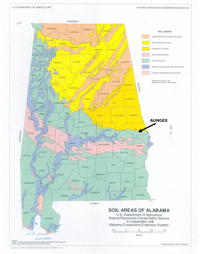
[5] | United States Department of Agriculture (1997) Soil Areas of Alabama, map, USDA NRCS National Cartography and Geospatial Center, Fort Worth, Texas. |
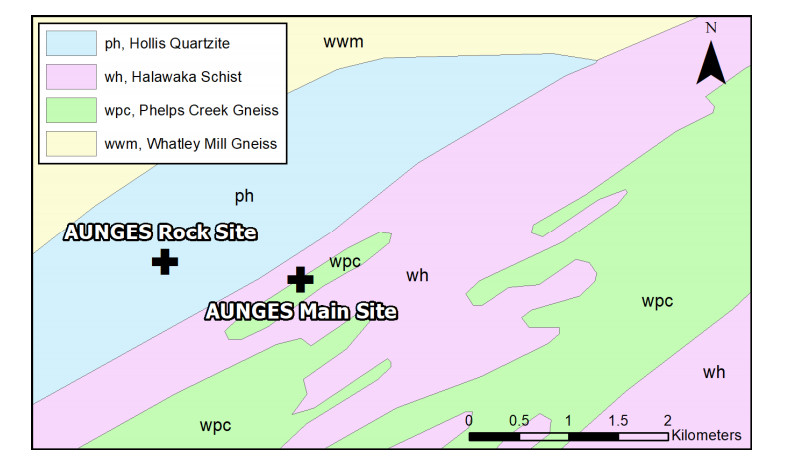
[6] | Yokel LS (1996) Geology of the Chewacla Marble and Associated Units, Lee County, Alabama. Master's Thesis, Auburn University, Auburn, AL. |
[7] | Kahle JK, Brown DA (2002) Performance of Laterally Loaded Drilled Sockets Founded in Weathered Quartzite. Auburn University Highway Research Center, Auburn, Alabama. |
[8] | Szabo MW, Osborne WE, Copeland CW, et al. (1988) Geological Map of Alabama. Special Map 220, Geological Survey of Alabama. |
[9] | Vinson JL, Brown DA (1997) Site Characterization of the Spring Villa Geotechnical Test Site and a Comparison of Strength and Stiffness Parameters for a Piedmont Residual Soil. Report No. IR-97-04, Highway Research Center, Harbert Engineering Center, Auburn University, AL. |
[10] | Mayne PW, Brown DA, Vinson JL, et al. (2000) Site Characterization of Piedmont Residual Soils at the NGES, Opelika, Alabama. National Geotechnical Experimentation Sites, ASCE GSP No. 93, 160–185. |
[11] | Mayne PW, Brown DA (2003) Site Characterization of Piedmont Residuum of North America. Charact Eng Prop Nat Soils 2: 1323–1339. |
[12] | McGillivray AV (2007) Enhanced integration of shear wave velocity profiling in direct-push site characterization systems. Ph.D. Dissertation, Georgia Institute of Technology, Atlanta, GA. |
[13] | Burrage RE (2015) Full Scale Testing of Two Excavations in an Unsaturated Piedmont Residual Soil. Doctoral Disseration, Auburn University. |
[14] | Skinner Z (2019) Theoretical Modeling and Lateral Load Testing of Driven Steel Pile Bridge Bents. Masters's Thesis, Auburn University. |
[15] |
Hebeler GL, Martinez A, Frost JD (2018) Interface Response-Based Soil Classification System. Can Geotech J 55: 1795–1811. doi: 10.1139/cgj-2017-0498
![]() |
[16] | Shi C (2018) Investigation of Deep Foundations at the Spring Villa National Geotechnical Experimentation Site. Master's Thesis, Auburn University. |
[17] | Montgomery J, Shi C, Anderson JB (2018) An Updated Database for the Spring Villa National Geotechnical Experimentation Site. IFCEE 2018: Installation, Testing, and Analysis of Deep Foundations, ASCE GSP No. 294. |
[18] | Brown DA (2002a) The Effect of Construction Technique on Axial Capacity of Drilled Foundations. Auburn University Highway Research Center, Auburn, Alabama. |
[19] | Brown DA (2002b) Report of Statnanic Tests on Rock Sockets at Spring Villa, Alabama. Auburn University Highway Research Center, Auburn, Alabama. |
[20] | Simpson M, Brown DA (2003) Development of P-Y curves for Piedmont residual soils. Auburn University Highway Research Center, Auburn, Alabama. |
[21] | Brown DA (1999) An Experiment with Statnamic Lateral Loading of a Drilled Shaft. Geotechnical Special Publication No. 88: Analysis, Design, Construction and Testing of Deep Foundations, Proceedings of the OTRC '99 Conference, ASCE, 309–318. |
[22] | Brown DA (2019) Personal communication. |
[23] | Robinson B, Rausche F, Likins GE, et al. (2002) Dynamic Load Testing of Drilled Shafts at National Geotechnical Experimentation Sites. Deep Foundations 2002, An International Perspective on Theory, Design, Construction, and Performance, Geotechnical Special Publication No. 116. |
[24] | Brown DA, Drew C (2000) Axial Capacity of Augered Displacement Piles at Auburn University. New Technological and Design Developments in Deep Foundations ASCE GSP No. 100. |
[25] | Brown DA, Nilsson JP (1998) Prefabricated Foundation Elements for Substation Structures. Final Project Report for Alabama Power Co. |
[26] | Brown DA, O'Neill WM, Hoit M, et al. (2001) Static and Dynamic Lateral Loading of Pile Groups. NCHRP 24-9, Transportation Research Board. |
[27] | Brown DA (2002c) Effect of Construction on Axial Capacity of Drilled Foundations in Piedmont Soils. J Geotech Geoenvir Eng 128: 967–973. |
[28] | Brown DA (2007) Rapid Lateral Load Testing of Deep Foundations. DFI 1: 54–62. |
[29] |
Hodgson D, Schindler AK, Brown DA, et al. (2005) Self-consolidating concrete (SCC) for use in drilled shaft applications. J Math Civil Eng 17: 363–369. doi: 10.1061/(ASCE)0899-1561(2005)17:3(363)
![]() |
[30] | Mullins G (2004) Factors Affecting Anomaly Formation in Drilled Shafts-final report. Final Rep. Submitted Florida Department of Transportation, Fla |
[31] | Mullins G, Ashmawy A (2005) Post grouting drilled shaft tips-Phase II final report. Final Rep. Submitted Florida Department of Transportation, Fla |
[32] | Burrage RE, Anderson JB, Pando MA, et al. (2012) A Cost Effective Triaxial Test Method for Unsaturated Soils. Geotech Test J 35: 50–59. |
[33] | Englert CM, Gómez JE, Wilkinson C, et al. (2015) Development of Removable Load Distributive Compressive Anchor Technology. IFCEE 2015, GSP No. 256, ASCE, Reston, VA. |
[34] | Marshall JD, Anderson JB, Campbell J, et al. (2017) Experimental validation of analysis methods and design procedures for steel pile bridge bents. Auburn University Highway Research Center, Auburn, Alabama. |
[35] | Anderson JB, Marshall JD, Campbell J, et al. (2018) Weak axis lateral load testing of a four H pile bent. IFCEE 2018, ASCE GSP 294, 419–427. |
[36] | Anderson JB, Marshall JD (2019) Weak axis lateral load testing of a four vertical H pile bent in residual soil at the Auburn National Geotechnical Experimentation Site. ISGTS 2019. |
[37] | Mayne PW (2000) Seismic Cone Testing at Spring Villa NGES Opelika-Auburn, Alabama. Available from: geosystems.ce.gatech.edu/Faculty/Mayne/Research/summer2000/opelika/opelika.htm. |
[38] | Sowers GF, Richardson TL (1983) Residual Soils of Piedmont and Blue Ridge. Transp Res Rec, 10–16. |
[39] |
Park C, Miller R, Xia J (1999) Multi-channel analysis of surface waves. Geophysics 64: 800–808. doi: 10.1190/1.1444590
![]() |
[40] | Martin GK, Mayne PW (1998) Seismic flat dilatometer tests in Piedmont residual soils. Geotech Site Charact 2: 837–843. |
1. | Jean-Sebastien L’Heureux, Tom Lunne, Characterization and Engineering properties of Natural Soils used for Geotesting, 2020, 6, 2471-2132, 35, 10.3934/geosci.2020004 |