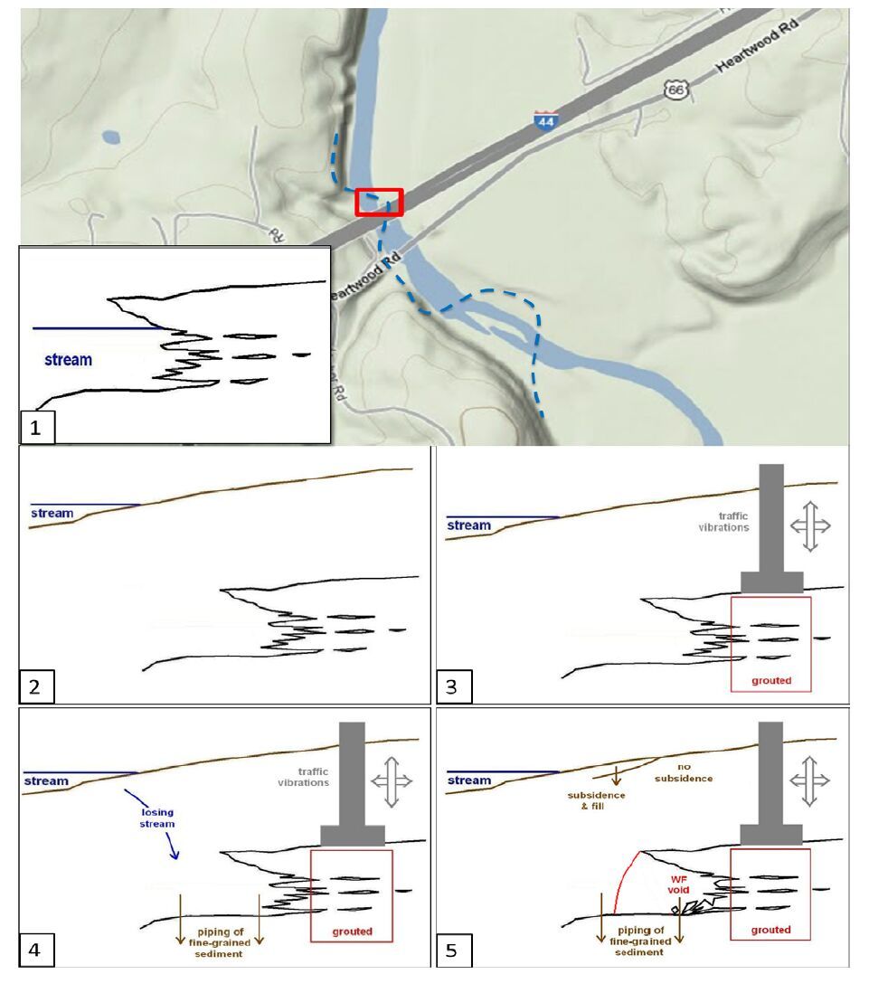
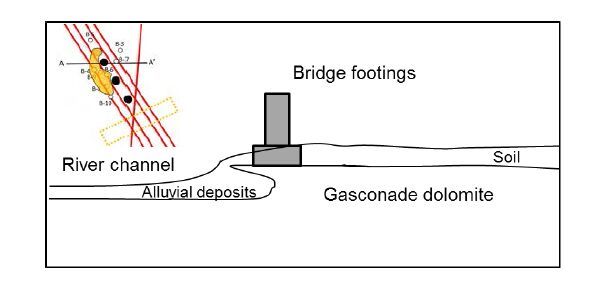
Citation: Evgeniy V. Torgashov, Aleksandra V. Varnavina. Site Characterization during Bridge Foundation Construction Using Electrical Resistivity Tomography[J]. AIMS Geosciences, 2016, 2(3): 201-213. doi: 10.3934/geosci.2016.3.201
[1] | Shishay Kidanu, Aleksandra Varnavina, Neil Anderson, Evgeniy Torgashov . Pseudo-3D electrical resistivity tomography imaging of subsurface structure of a sinkhole—A case study in Greene County, Missouri. AIMS Geosciences, 2020, 6(1): 54-70. doi: 10.3934/geosci.2020005 |
[2] | Abdallah Basiru, Shishay T Kidanu, Sergei Rybakov, Nicholas Hasson, Moustapha Kebe, Emmanuel Osei Acheampong . Electrical Resistivity Tomography Investigation of Permafrost Conditions in a Thermokarst Site in Fairbanks, Alaska. AIMS Geosciences, 2024, 10(1): 1-27. doi: 10.3934/geosci.2024001 |
[3] | Stanley C. Nwokebuihe, Abdulrahman M. Alotaibi, Adel Elkrry, Evgeniy V. Torgashov, Neil L. Anderson . Dam Seepage Investigation of an Earthfill Dam in Warren County, Missouri Using Geophysical Methods. AIMS Geosciences, 2017, 3(1): 1-13. doi: 10.3934/geosci.2017.1.1 |
[4] | Christopher Talbot, Nico Augustin . Submarine Salt Karst Terrains. AIMS Geosciences, 2016, 2(2): 182-200. doi: 10.3934/geosci.2016.2.182 |
[5] | Eve-Agnès Fiorentino, Sheldon Warden, Maksim Bano, Pascal Sailhac, Thomas Perrier . One-off geophysical detection of chlorinated DNAPL during remediation of an industrial site: a case study. AIMS Geosciences, 2021, 7(1): 1-21. doi: 10.3934/geosci.2021001 |
[6] | Aleksander S. Gundersen, Ragnhild C. Hansen, Tom Lunne, Jean-Sebastien L’Heureux, Stein O. Strandvik . Characterization and engineering properties of the NGTS Onsøy soft clay site. AIMS Geosciences, 2019, 5(3): 665-703. doi: 10.3934/geosci.2019.3.665 |
[7] | Graham L. Gilbert, Arne Instanes, Anatoly O. Sinitsyn, Arne Aalberg . Characterization of two sites for geotechnical testing in permafrost: Longyearbyen, Svalbard. AIMS Geosciences, 2019, 5(4): 868-885. doi: 10.3934/geosci.2019.4.868 |
[8] | Paolo Dell'Aversana . Reservoir prescriptive management combining electric resistivity tomography and machine learning. AIMS Geosciences, 2021, 7(2): 138-161. doi: 10.3934/geosci.2021009 |
[9] | Priscilla Addison, Pasi Lautala, Thomas Oommen . Utilizing Vegetation Indices as a Proxy to Characterize the Stability of a Railway Embankment in a Permafrost Region. AIMS Geosciences, 2016, 2(4): 329-344. doi: 10.3934/geosci.2016.4.329 |
[10] | David Igoe, Kenneth Gavin . Characterization of the Blessington sand geotechnical test site. AIMS Geosciences, 2019, 5(2): 145-162. doi: 10.3934/geosci.2019.2.145 |
The Gasconade westbound lane bridge, constructed in 1955, carries west-bound interstate (I-44) traffic over the Gasconade River in Laclede County, Missouri (Figure 1). In 2011 a temporary substructure north of the existing bridge was constructed to support a replacement bridge deck. After the replacement deck was completed, the existing deck was removed, the replacement deck was transferred onto the existing bridge foundations [1].
The project site is located in the Salem Plateau region, near the contact between the Gasconade Dolomite and the overlying Roubidoux Sandstone (Figure 2 [2]). Gasconade Dolomite was encountered in all the project boreholes. The rock in the area is susceptible to karst.
The sloping valley floor first intercepts the Gasconade Dolomite directly upstream of the project site, and cuts deeper into the Gasconade as it progresses downstream. The Gasconade Dolomite is represented mostly by a light brownish-gray, cherty dolomite, and is highly weathered in the study area. The Roubidoux Formation, overlying the Gasconade, outcrops on the valley slopes in the vicinity of the project site (Figure 3 [3,4]).
The Roubidoux consists of dolomite, cherty dolomite, sandy dolomite, dolomitic sandstone, and sandstone. The Jefferson City Dolomite, is also present and caps the uplands in the study area, it primarily consists of medium- to finely crystalline dolomite. Structurally there are two known faults trending northwest-southeast south of the study area but no known faults extend thru the project site. The preferential orientation of the surface water flow in the study area is consistent with the orientation of the joints in the area (Figure 4). Joints in the Ordovician rocks are vertical to subvertical and have a bimodal distribution with the trends of 340°-0° and 70°-90° [5].
Topographic lineaments do not suggest that a major bedrock joint set (sets) runs thru the project site. It is common for the Gasconade Dolomite have karst development, but no major karst features such as sinkholes or swallow holes are known to occur in the vicinity of the project. The only known sinkhole is located approximately 5.6 km away. Three springs are shown to surface within 4.8 km of the project site; two within the Roubidoux Formation and one at the Roubidoux-Gasconade contact.
The karst topography causes the longest losing stream segment (53 km) of the Gasconade River in its watershed [6]. A losing steam is defined as “a stream that loses 30 percent or more of its flow into an aquifer within two miles of flow discharge” (definition by MDNR Clean Water Commission Water Quality Standards 10 CSR 20-7.01, 1994). The losing portion of the river starts about 7.5 km downstream from the site or approximately 2.5 km on direct line (Figure 4).
The soil encountered in the borings at the study site consisted of lean clay and silty alluvium with varying amounts of transported sand and gravel derived from the weathering of the Gasconade and Roubidoux formations [7]. Borehole control indicates soil at the study site ranges from 4.3 to 7.9 m thick.
A total nine boreholes were drilled at the study site during and after aquisition of the ERT data to constrain and verify the geophysical data interpetation. Boreholes B-3 and B-7 were adjacent to ERT Traverse 1; borehole B-5 was located between ERT Traverses 2 and 3; borehole B-6 centered on ERT Traverse 3; borehole B-9 was located between ERT Traverses 3 and 4; and boreholes B-4, B-8, B-10 and B-11 were located near or on ERT Traverse 4 (Figures 1 and 7).
During the drilling program, competent Gasconade Dolomite was encountered in the boreholes B-3 and B-4 adjacent to the foundation of the east bound lane bridge (Figures 1 and 7). The extensive water-filled cavity of interest within the Gasconade Dolomite was encountered in Boreholes B-4 (6.5 to 8.4 m), B-6 (6.3 to 6.4 m and 7.1 to 8.2 m), B-8 (6.9 to 8.4 m), and B-9 (immediately adjacent to Bent 6 Bridge L-0698; 6.7 to 8.4 m). Vuggy dolomite was encountered in Boreholes B-7 (at a depth of 5.9 m), B-5 (at a depth of 5.6 m), B-11 (at a depth of 6.3 m). Weathered rock encountered in Boreholes B-6 (at a depth 5.6 m) and in B-9 (at a depth of 6.2 m). The ovelaying soil consisted of soft brown lean clay and gray silty clay, with gravel fragments. Boring summary is presented in Figure 5.
Electrical resistivity profiles were acquired along five traverses (Traverses 1, 2, 3, 4 and 5, Figure 1) in an effort to determine the extent of the encountered water-filled cavity and map variations in rock quality in immediate proximity to the existing permanent bridge foundations. The ERT data were acquired using an AGI SuperSting R8/IP resistivity unit equipped with adipole-dipole array consisting of 72 electrodes (Figure 6). Typical depth of investigation is 20 percent of the length of the electrical resistivity array. With 72 available electrodes and the required depth of investigation 11.0 m, a 0.76 m spacing between the electrodes was selected for this ERT survey in order to image any significant features in the subsurface that can affect the integrity of bridge foundations. The ERT data were acquired in February, after two days of rain. The acquired ERT field data were fair to good quality and were processed using the RES2DINV software. Percentage of noisy data points removed during processing was between 5 and 15 percent, the error after 7 iterations with the robust constrain gave the RMS as high as 13 percent. The ERT profiles imaged the subsurface to a depth of about 11.0 m, which is about 20% of the array length.
Top of rock in proximity to the foundation of the eastbound lane bridge (location marked as C1 and C2 in Figure 9 and 13) was interpreted at a depth of approximately 3.0 m immediately to the east of the structure (Figure 1), to 4.9 m immediately to the west of the structure (Figures 1 and 7). Top of rock in proximity to the foundation of the eastbound lane bridge (location marked as C1 and C2 in Figure 7) was interpreted at a depth of approximately 3.0 m immediately to the east of the structure, to 4.5 m immediately to the west of the structure. Bedrock beneath the eastbound lane bridge foundation was characterized by resistivity values of 200 ohm·m and higher and was interpreted as competent rock. The interpretation was consistent with limited borehole control (borehole B-11). The overlying soil was characterized by resistivity values of less than 200 ohm·m, except where shallow gravels appeared to be present [8].
Interpreted ERT Profiles 1-5 are shown in Figure 7. Solid black line represents an interpreted top of bedrock, dashed black line shows estimated depth to top of rock based on the borehole control and bridge footings depth. Crossing locations of Traverse 5 are marked as T5 in Profiles 1-4 (Figure 7A). Crossing locations of Traverses 1, 2, 3 and 4 are marked as T1, T2, T3 and T4 in Profile 5 accordingly. Foundations (Columns 1 and 2) of eastbound lane bridge are marked as C1 and C2. Foundations (Columns 3, 4 and 5) of westbound lane bridge marked as C3, C4 and C5.
Interpreted embankment fill (marked as black dotted line, Figure 7B) in the top part of the profile characterized by resistivity values of 200 ohm·m and higher. The southern part of the profile (16-m to 21-m mark) has lower resistivities (140 ohm·m or less) compared to the surrounding rock with the values of 200 ohm·m or higher.
This prominent geologic feature is characterized by an approximately 5-m wide low resistivity zone (compared to surrounding resistivity values at comparable depths in the study area), imaged on the ERT profiles 1-4 at about 16.0 to 21.0 m marks (Figure 7A) and on the ERT profile 5 at about 11.0 to 13.0 m marks (Figure 7B).
The interpreted solution-widened joint, trending southwest-northeast, was superposed on the ERT profiles location map (marked as orange dotted rectangular, Figure 8) and on a map of with marked preferential surface flow path in the study area (Figure 4). The orientation of the interpreted solution-widened joint was consistent with the preferential surface path flow oriented west-southwest-east-northeast and perpendicular to the known faults and lineaments in the study area [4].
The interpreted electrical resistivity tomography data and borehole control did not indicate the presence of other than the encountered water-filled rock openings at the study site. However, volume of injected grout (60 cubic meters) suggested the area of extension of the water-filled rock opening, assuming the rock opening height 1.5 m, was up to approximately 8.0 m by 5.0 m (Figure 8). The ERT method was not able to map the water-filled rock opening due to the similar resistivity values of saturated weathered and vuggy rock and water-filled rock opening.
Also, based on the interpretation it was concluded that the east bound lane bridge foundation was founded on relatively more competent and shallower rock at a depth of 3.0 m, the top of weathered, highly fractured and vuggy rock beneath the west bound lane foundation was at a depth of about 6.0 m [9]. A zone of lower apparent resistivity values, presumably a vertical solution-widened joint trending west-southwest-east-northeast, was mapped. The orientation of the mapped joint is consistent with joint system in the area.
Rock opening development could be explained by a five stage conceptual model (Figure 9): the eastern river bank is undercut by the meandering stream (stage 1), and subsequently filled with sediments such as alluvium (stage 2). After the bridge foundations were installed and rock was grouted where necessary, vehicle traffic created vibrations in the rock (stage 3). The vibrations along with the seasonal water level changes triggered subsidence of the sediments (stage 4). Piping effect of fine-grained sediments by the losing/gaining stream into cavernous rock and possibly solution-widened joint caused its removal and later created water-filled rock opening (stage 5).
A conceptual cross-section of the site showing is shown in Figure 10. The bridge footing is resting on top of rock, partially on portion of rock undercut by the meandering stream. Alluvial deposits are filling the river channel. Rock is presented by Gasconade dolomite which is vuggy/cavernous at the project site and highly susceptible to karst.
Interpretation and analyses of the electrical resistivity tomography data and borehole control did not indicate any water-filled or air-filled rock openings except the encountered one were present at the study site. The rock opening encountered during the drilling program, was water-filled and most likely developed by a combination of factors such as meandering stream activity, traffic vibration and piping effect of a losing/gaining stream. Based on the injected grout volume of 60 cubic meters and the electrical resistivity tomography data with borehole control it was estimated that encountered water-filled rock opening was up to 1.8 m high and could have an area extension of over 40 square meters.
This water-filled rock opening had resistivity values similar to surrounding vuggy and weathered rock high in water content. Due to these geological conditions it was difficult to differentiate the rock openings from the surrounding weathered and vuggy saturated rock. Also in some places it was impossible to differentiate soil overlaying rock based only on the ERT data. Based on the ERT and the borehole data it was concluded that the foundations of the eastbound lane bridge were found on shallower and competent rock. Westbound lane bridge foundations were found on fractured and weathered rock, which was grouted prior to an initial bridge construction in the 1950-s. A five-stage conceptual model how the rock opening formed is offered.
A solution-widened joint, trending west-southwest-east-northeast was mapped based on the interpretation of the ERT data. Analyses of the known faults and structural lineaments, trending south-east and southwest-west-northeast-east, supported the interpretation that a solution-widened fracture zone, trending west-southwest-east-northeast, runs thru the project site. The solution-widened fracture zone also follows the orientation of the preferential surface water flow.
All authors declare no conflicts of interest in this paper.
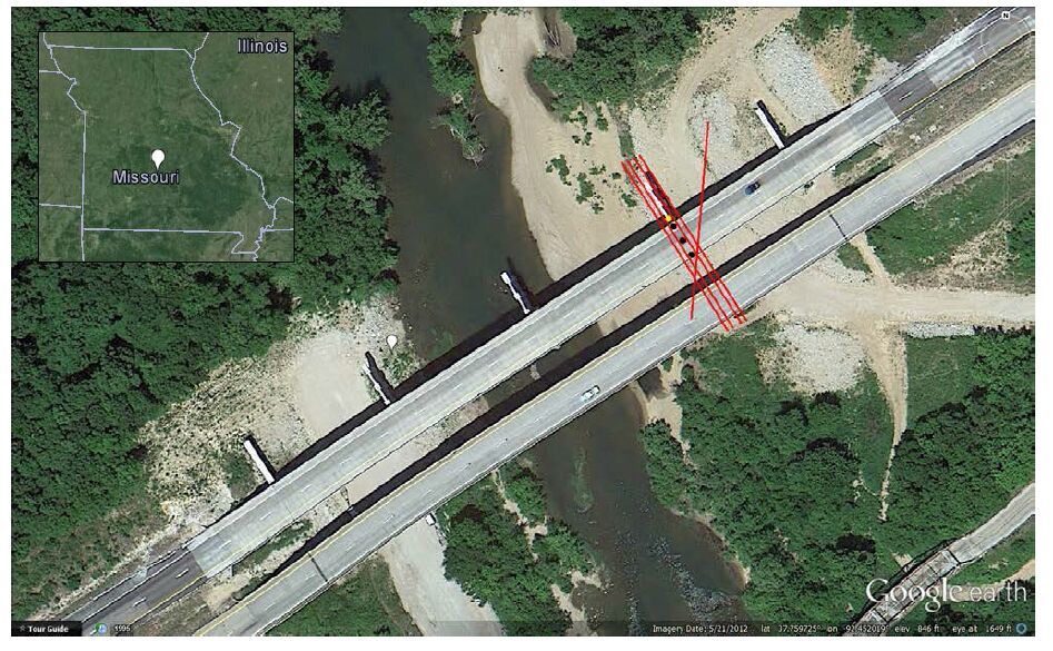
[1] | I-44 Gasconade River Bridge Rehabilitation: New-to-Missouri Construction Technique. Missouri DOT, 2011. Available from: http://www.modot.org/central/major_projects/I-44GasconadeRiverBridge.htm. |
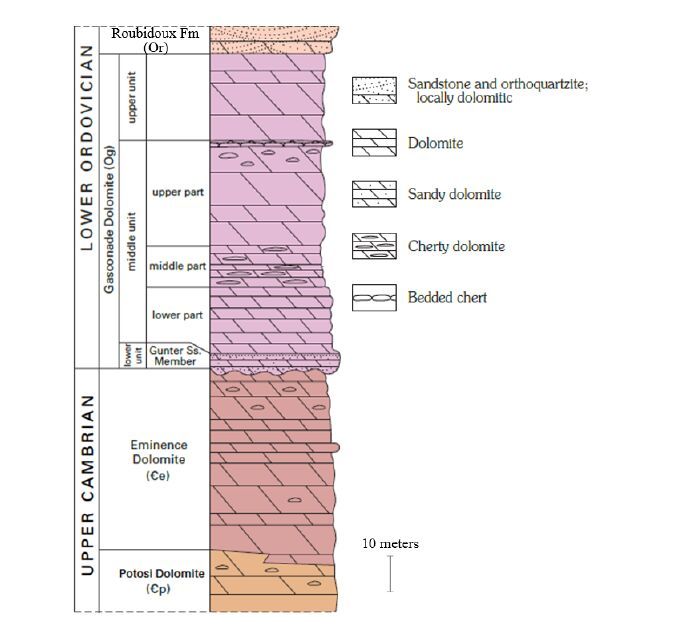
[2] | Geologic map of the Alley Spring Quadrangle, Shannon County, Missouri, David J. Weary and Randall C. Orndorff, 2012. Available from: http://pubs.usgs.gov/sim/3161/pdf/sim3161_alleyspring_mo.pdf. |
[3] | Gamble EE. Geomorphic Study in the Upper Gasconade River Basin, Laclede and Texas Counties, Missouri: Soil Survey Investigations Report No. 43. 1993. Available from: http://www.nrcs.usda.gov/Internet/FSE_DOCUMENTS/nrcs142p2_052869.pdf |
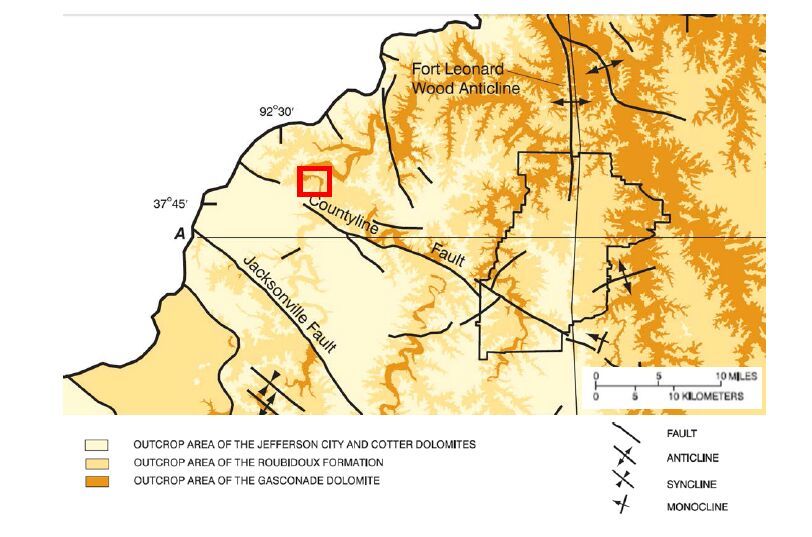
[4] | Mugel DN and Imes JL. (2003) U.S. Geological Survey, Water-Resources Investigations Report 03-4165, Geohydrologic Framework, Ground-Water Hydrology, and Water Use in the Gasconade River Basin upstream from Jerome, Missouri, including the Fort Leonard Wood Military Reservation: 10-22. |
[5] | Orndorff RC, et al. (2001) U.S. Geological Survey Karst Interest Group Proceedings, Water-Resources Investigations Report 01-4011: 18-24. |
[6] | Blanc TJ. (2001) Missouri Department of Conservation, Gasconade River Watershed Inventory and Assessment. 12-16. |
[7] | Miller DE and Vandike JE. (1995) Missouri Department of Natural Resources: Groundwater Resources of Missouri. Missouri State Water Plan Series, 2: 46-47 |
[8] | Torgashov EV. (2011) Imaging the Subsurface in Karst Terrain Using Electrical Resistivity Tomography. Missouri University of Science and Technology, PhD dissertation, 71-91. |
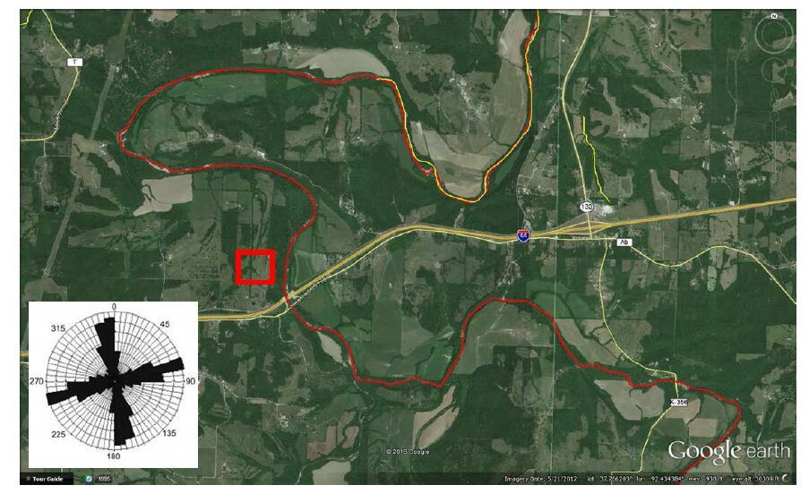
[9] | Smotherman B. (2010) The Influence of Lineaments on the Geology of Missouri. Available from: http://academic.emporia.edu/aberjame/student/smotherman2/globaltect2.htm. |
1. | Aleksandra V. Varnavina, Aleksey K. Khamzin, Shishay T. Kidanu, Neil L. Anderson, Geophysical site assessment in karst terrain: A case study from southwestern Missouri, 2019, 170, 09269851, 103838, 10.1016/j.jappgeo.2019.103838 |