
Citation: Amir Hedayati Aghmashhadi, Giuseppe T. Cirella, Samaneh Zahedi, Azadeh Kazemi. Water resource policy support system of the Caspian Basin[J]. AIMS Environmental Science, 2019, 6(4): 242-261. doi: 10.3934/environsci.2019.4.242
[1] | Seiran Haghgoo, Jamil Amanollahi, Barzan Bahrami Kamangar, Shahryar Sorooshian . Decision models enhancing environmental flow sustainability: A strategic approach to water resource management. AIMS Environmental Science, 2024, 11(6): 900-917. doi: 10.3934/environsci.2024045 |
[2] | Alozie Alaoma, Nikolaos Voulvoulis . Mineral resource active regions: The need for systems thinking in management. AIMS Environmental Science, 2018, 5(2): 78-95. doi: 10.3934/environsci.2018.2.78 |
[3] | Mounir OUABA, Mohamed Elmehdi SAIDI . Contribution of morphological study to the understanding of watersheds in arid environment: A case study (Morocco). AIMS Environmental Science, 2023, 10(1): 16-32. doi: 10.3934/environsci.2023002 |
[4] | Laura Romero, Modesto Pérez-Sánchez, P. Amparo López-Jiménez . Improvement of sustainability indicators when traditional water management changes: a case study in Alicante (Spain). AIMS Environmental Science, 2017, 4(3): 502-522. doi: 10.3934/environsci.2017.3.502 |
[5] | Chukwuebuka Okafor, Charles Ajaero, Christian Madu, Kingsley Agomuo, Ezekiel Abu . Implementation of circular economy principles in management of end-of-life tyres in a developing country (Nigeria). AIMS Environmental Science, 2020, 7(5): 406-433. doi: 10.3934/environsci.2020027 |
[6] | Ankit Srivastava, T.C. Prathna . Urban water resource management: experience from the revival of Rajokri lake in Delhi. AIMS Environmental Science, 2021, 8(5): 421-434. doi: 10.3934/environsci.2021027 |
[7] | RAHMOUN Ibrahim, BENMAMAR Saâdia, RABEHI Mohamed . Comparison between different Intensities of Rainfall to identify overflow points in a combined sewer system using Storm Water Management Model. AIMS Environmental Science, 2022, 9(5): 573-592. doi: 10.3934/environsci.2022034 |
[8] | Huixuan Li, Cuizhen Wang, Yuqin Jiang, Andrew Hug, Yingru Li . Spatial assessment of sewage discharge with urbanization in 2004–2014, Beijing, China. AIMS Environmental Science, 2016, 3(4): 842-857. doi: 10.3934/environsci.2016.4.842 |
[9] | Joje Mar P. Sanchez, Marchee T. Picardal, Marnan T. Libres, Hedeliza A. Pineda, Ma. Lourdes B. Paloma, Judelynn M. Librinca, Reginald Raymund A. Caturza, Sherry P. Ramayla, Ruby L. Armada, Jay P. Picardal . Characterization of a river at risk: the case of Sapangdaku River in Toledo City, Cebu, Philippines. AIMS Environmental Science, 2020, 7(6): 559-574. doi: 10.3934/environsci.2020035 |
[10] | Sonia Prestamburgo, Filippo Sgroi, Adriano Venudo, Carlo Zanin . Universal design as resilient urban space plan strategy. New scenarios for environmental resources' sustainable management. AIMS Environmental Science, 2021, 8(4): 321-340. doi: 10.3934/environsci.2021021 |
Water resource policy increasingly recognizes that human and ecological systems are complex and adaptive, characterized by cross-scale interaction and high uncertainty [1,2]. Globally, insufficient water resources have been highlighted as critical in several regions and linked to food insecurity [3,4,5]. Increasing conflict associated with outdated or inadequate water allocation systems, the need to consider multiple interests of indigenous people [6], licensed users, and general stakeholders, coupled with the growing industrial, agricultural, and urban demand for fresh water are all driving an interest in water policy reform [7,8,9]. In accordance with these issues, water resource policy support systems (WRPSSs) in arid and semi-arid areas in developing countries suffer, in particular, from inappropriate system implementation. Main drawbacks focus on singular approaches (i.e., specific to human or non-human dimensions) without the integration of an all-inclusive holistic view [10,11,12,13,14]. Other disadvantages include trust and responsibility in upholding key policy support system (PSS) findings as well as the aptitude to acknowledge the need for environmental reform. Thus, a systematic approach would be beneficial due to uncertainties in developing sound PSSs that support full societal and juridical enforcement.
To address these problems and promote the quality and accountability of a reliable WRPSS directive we propose the following steps. First, all pressure factors which have impact on water resources–in any specific geologic, social or economic area–must be documented, monitored, controlled, and compared overtime. Prioritization should be set via unique water resource units and assessed in relation to historical records. Second, to best amalgamate pressure parameters the use of fuzzy logic in conjunction with the analytic network process method used. Added to these drivers are additional broader factors including climate change and its impact on the hydrological cycle, political and environmental reform, and growing public awareness regarding water issues [15]. Studies that examine these drivers are widespread [16,17,18]. A growing emphasis, particularly by scholars, has stressed the need for water policy innovation, and in some cases "radical" change, in the processes that enable and shape it [19,20].
Exploring developments in socio-hydrological modeling, it is unclear whether existing examples of coupled human-to-water models reflect an overemphasis on calibrated data or an accurate representation of known relationships. In cognition of human-to-water interconnectivity key research approaches have been studied, including: hydro-ecological modeling [21], hydro-economic modeling [22], socioeconomic tools applied to water systems [23], socio-hydro-systems [24], and applications of socio-hydrology [22]. To address these concerns, over the past three decades, a number of optimization models have been developed [25,26,27,28,29,30,31,32,33]. Specifically, two dated techniques incorporate Slowinski's [25] interactive fuzzy multi-objective linear programming method and its applicability to water supply planning; whilst, Huang [34] put together an interval-parameter programming method for dealing with uncertainties expressed as interval numbers in a water resource management system. Nine more recent innovative techniques have emerged with the rise of technological invention and computing. Bender and Simonovic [35] proposed a fuzzy compromise approach to water resource planning with regard to imprecision uncertainty [36]. Jairaj and Vedula [27] optimized a multi-reservoir system by using a fuzzy mathematical programming technique where uncertainties existing in reservoir inflows were treated as fuzzy sets. Faye et al. [37] proposed a fuzzy approach for short-term water resource systems with the specificity of logging uncertainty. Lee and Chang [38] put together an interactive fuzzy approach for planning stream water resource management that unfortunately incorporated abstract and often imprecise data. Edirisinghe et al. [39] proposed a mathematical programming model for the planning of reservoir capacity under random stream flows based on a chance constrained programming method with a special target-priority policy in accordance to given system reliabilities. Azaiez [40] developed a multi-stage optimization model for supporting the conjunctive use of ground and surface water with an artificial recharge, where a certain supply and random demand were assumed and opportunity costs for any unsatisfied demand were explicitly integrated. Pallottino et al. [41] presented a scenario analysis approach for water system planning and management under conditions of climatic and hydrological uncertainty. Li et al. [42] proposed an interval-parameter multi-stage stochastic programming method for supporting water resource decision making, where uncertainties were expressed as discrete random variables and interval values. Finally, Nasiri et al. [43] pieced together fuzzy multiple-attribute an expert decision support system for dealing with the uncertainties surrounding water resource management problems associated with policy decision-oriented research.
While the constructs for socio-hydrological modeling have been studied in various forms, the parameterization of human behavior in such modeling remains relatively rare. This lack of attention prompts for the investigation of approaches that can integrate socioeconomic management with hydrological modeling by simulating the interaction of human systems with hydrological ones, addressing water needs for society and ecosystems alike [44], and representing the dynamic nature of water demand within the context of a PSS. Within the scope of environmental conflict resolution, management concerns are categorized into three main components: policy, planning, and decision making [12,45,46]. These components start with policy as the highest level in which coordination, together with road map development, utilize an action plan, control activities, and decide how best to proceed. In this paper, the WRPSS focalizes on the first of these components by determining and setting preface controls for best practices. The utilization of pressure parameters in the Caspian Basin are first introduced and would require further planning and decision making processes for full implementation. The use of the WRPSS embodies interactions in a multidisciplinary approach. As an adaptive-oriented practice, WRPSS assesses water suitability and presents human and non-human pressure factors automated by two main features: (1) water policy modifications suitable to local environmental conditions for water evaluation and (2) development of spatial tools to derive criteria weights. The use of the WRPSS would provision for realistic, practicable, and functionally-sound Iranian-centric Caspian Basin water policy. The WRPSS model promotes a holistic concept that encompasses sustainability with upgradeability (i.e., via the Internet), remote sensing imagery, and knowledge-base from historical sources. The aim of the research is, thus, to address the problems and promote quality and accountability of using a WRPSS. A breakdown of the paper is structured as follows: Section 2 defines the methodology, Section 3 outlines the development of research methods, Section 4 elucidates the results and discussion, and Section 5 is the conclusion.
In many real world problems uncertainties may be expressed as random variables, hence, their systemic relationship may have some dynamic characteristics that affect probabilistic measures and the like [47]. As a result, relevant decisions must be made at each time-stage under varying probabilistic levels. Such circumstances can be formulated as a scenario-based multi-stage stochastic programming model. In this paper, the reliability of the WRPSS model follows two main steps. First, identified water resource pressure factors from the Iranian side of the Caspian Basin are scored and prioritized using drivers, pressures, state, impact, as well as the response model of intervention (DPSIR) framework. Second, pressure parameters on freshwater resources are categorized, by way of: (1) human and non-human criteria and eight sub-criteria questionnaires, (2) qualitative findings from 36 specialists in environmental planning and management, and (3) the fuzzy analytic network process (FANP) method. The design of data layers is integrated using IDRISI GIS Analysis as well as image processing software, before being overlaid into ArcGIS Pro software. The PSS framing of the dual software procedure is illustrated in Figure 1. The positive aspects of using this approach is its all-inclusivity of being able to perform multi-valued logical truths based on the observed pressure parameters. However, the framing is data intensive and requires expert knowledge in piecing it together. The data can sometimes be vague and lack certainty [5].
The Caspian Basin, one of seven main watersheds in Iran, is divided into seven secondary level sub-basins. The Caspian Basin has the highest level of rainfall of all the major basins, extending from the northeast to northwest of the country. The Caspian Basin is located in the south of the Caspian Sea and north of the Alborz Mountains with a landmass of 206,750 km2 (Figure 2).
The prime motivation for policy making and planning of water resources in the Caspian Basin is the danger of water crises. The Basin currently is made up of thirteen provinces and houses more than 20% of Iran's population. Moreover, in regards to annual precipitation it averages more than 500 mm per year, supplying other areas of the country during water shortage and drought. These important facts play a primary role in the livelihood of the region as well as supporting sustainability-based thinking. Taking effective steps, in terms of water resource policy, the use of systematic, precautionary, and pressure management planning and policy is the core development methodology of the WRPSS. In order to decrease the burden on water resources derived within the Basin, especially caused by human activities, the WRPSS has immediate priority.
The DPSIR model is derived from a system's analysis viewpoint on environmental problems and investigates the way society deals with such concerns. The specific terminological definitions of the model include social and economic developments (i.e., driving forces, D), exert pressures (P) on the environment and, as a consequence, the state (S) of the environment changes. This leads to impacts (I) on ecosystems, human health, and society, which may terminate a societal response (R) that feedback on driving forces, on state, or on impacts [48] (Figure 3) [49,50]. The DPSIR model has been described as a "causal framework for describing the interactions between society and the environment" [51].
The utilization of the DPSIR model allowed for the analysis of environmental conditions within each region by way of combining holistic and systematic views. Since the model is a well-established framework, possible connection and ability to gauge the effectiveness of responses, put into place, suited the study. It is also appropriately framed for organizing and categorizing pressure parameters based on cause-and-effect which is especially significant throughout the vast landmass of the Caspian Basin where data is often limited.
Multi criteria evaluation method (MCE) attempts to reach a specific goal by means of required evaluations across several performance-based criteria [52,53,54]. The purpose of a MCE is to select the best alternative (i.e., the best sub-basin within the study area), based on ranked reachable resources acquired from the evaluation. Several common MCE methods of analyzing such data include: weighted linear combination method (WLC), Boolean method, fuzzy approach, value approach function desirability, analytic hierarchy process (AHP), ideal point method, and agreement method [55]); for this study, we have chosen a dual approach: fuzzy approach and WLC. The first process involves the overlapping of fuzzy results whereby all criteria is reduced to the appropriate logic modes before being combined by one or more logical operators such as a subscription (i.e., AND) or sum (i.e., OR).
The second process is the WLC, the most common technique in the analysis of MCE, in which continuous metrics (i.e., factors) standardizes data to a normal numerical range, combined with a weighted average [54]. Simply stated, this technique utilizes a scoring method based on average weight, analyzer or decision maker, and weighted criteria based on the relative importance of each criterion. Next, by multiplying the relative weight in the attribute value, a final value is obtained for each alternative after specifying each alternative value (i.e., the alternative that has the greatest value is selected as the most appropriate alternative for the intended purpose). In this selection-oriented process, the value of each alternative is calculated using Equation. 1 [56].
(1) |
WLC is run within a GIS and overlaid into the system. Overlaying techniques (i.e., superimposing layers of mapped data) in GIS allow for combinative standard layered mapping (i.e., an input map) and an integrative constructed composite map (i.e., an output map) [57]. As such, these maps create the thematic results needed to generate the final result.
The AHP, firstly proposed by Saaty [58], is a popular method for solving multi criteria analysis problems involving qualitative data [59]. As a consequence, multi criteria prioritization methods that utilize PSS when faced with complex and uncertain environments suggest a FANP approach for prioritizing parameters. Such methodological reasoning takes into account flexible, quantitative data for selecting alternatives based on relative performance with respect to one or more criteria [60,61]. Since criteria in the real world are dependent on each other, the traditional approaches in this area are not properly measurable. As a result, Saaty [58] proposed an analytical network process from the developed AHP to obtain a set of suitable weights for the criteria [62,63]. This method is used to recognize the purpose of the PSS and all parameters of the hierarchical process. As such, pairwise comparisons should demonstrate the priority of parameters to each other, even if they lack system recognition, in which general deficiency in absolute certainties is resolved by use of a network analysis model. In the absence of uncertainty, using fuzzy comparisons, the solution is modeling such uncertainties, in so that, if individual opinions are the reason for low accuracy, perception will not be expressed in terms of absolute numbers rather than a range of numbers. As such, individual perceptions reflect upon the importance of the phenomenon rather than other phenomena [64,65].
In this method all factors are combined with each other into one step in which we use purposeful patterns of integrative and implementative mapping. Fuzzy logic considers space objects as members of a set. In a fuzzy set theory, membership can obtain any value between zero and one which reflects a certain value of membership in which no practical constrains on choosing fuzzy membership values exist [66,67,68,69]. Fuzzy logic method creates flexible compounds of weighted maps that can easily be implemented into GIS modeling language [67]. The values are chosen based on subjective judgement when obtaining membership values of any set (Figure. 4).
To construct the approach, five fuzzy operators (i.e., AND, GAMMA, OR, SUM, and PRODUCT) are used for combining datasets in GIS, as follows:
1 –fuzzyAND: similar to the subscription in classic sets where its effect is an output map handled with the smallest amount of fuzzy membership that may occur in any situation [70].
2 –fuzzyGAMMA: operation and its algebraic combinative methodology of fuzzyPRODUCT and fuzzySUM obtained from Equation. 2.
(2) |
Where: γ parameter is selected in the range of zero and one, in which if γ equals zero it illustrates fuzzyPRODUCT whereas if it is one it shows fuzzySUM composition [71,72].
3 –fuzzyOR: similar to the sum in classic sets where the operator is an output map handled with the largest amount of fuzzy membership which occurs in any situation [70].
4 –uzzySUM: supplemental of fuzzyPRODUCT in which it is always greater than or equal to the biggest fuzzy membership [73].
5 –fuzzyPRODUCT: combines fuzzy membership by multiplying sums; that is, it is a decreasing model which the output value is always less than or equal to the smallest fuzzy membership [74].
Within the Caspian Basin, all the identified factors are first scored into pressure factors from available water resources. This is based upon a number of principles focalizing on environmental management within the scope of freshwater resources. Pressure points are identified utilizing the DPSIR model, as depicted in Figure 5.
After preparing the data for the DPSIR model, the implementation of the FANP model was used, within the Caspian Basin, for the weighting and prioritization of pressure factors on freshwater resources.
Pressure factors are identified by the use of the DPSIR model and provide data layers for mapping. The following factors are analyzed for policy making, planning, and integrated management of freshwater resources: (1) agricultural water use, groundwater use, water pollution, dam building, population density, and changes in land cover as the human sub-criteria and (2) changes in the wetlands and drought as the non-human sub-criteria. Thereafter, mutual dependence of indicators and components are developed as shown in Figure 6.
The development of the tables and weighting of parameters were done using FANP and ASP programming language [75]. Using this software, we calculated the compatibility of the data, using Gogus and Boucher [76]. Data collection for weighting and prioritization of parameters is based on the distributed questionnaires among 36 specialists within environmental and water resource planning.
Pairwise comparisons of criteria and sub-criteria are shown in Tables 1 and 2. The results have been comprised from expert opinion.
Criteria | Final fuzzy weight of Criteria | Final weight of Criteria |
Non-human | (0.172, 0.182, 0.223) | 0.193 |
Human | (0.668, 0.818, 0.862) | 0.807 |
Sub-criteria | Final fuzzy weight of Sub-criteria | Final weight of Sub-criteria |
Degradation of wetland | (0.039, 0.05, 0.077) | 0.053 |
Drought | (0.099, 0.149, 0.194) | 0.149 |
Water pollution | (0.113, 0.174, 0.234) | 0.175 |
Agricultural water use | (0.147, 0.252, 0.308) | 0.243 |
Dam building | (0.027, 0.038, 0.05) | 0.039 |
Population density | (0.042, 0.068, 0.091) | 0.069 |
Land cover changes | (0.059, 0.087, 0.123) | 0.089 |
Groundwater use | (0.111, 0.184, 0.243) | 0.183 |
In fuzzy logic, according to the value which follows the intended criterion, each sub-basin obtains a membership value that expresses the desirability of the corresponding region. It is unlike Boolean logic, in that each layer is rated to a scale, either zero or one [77]. Another influential factor in fuzzy map standardization is determining the threshold boundaries which are called control points. Moreover, in choosing a function one should consider the type of intended criterion that is increasing or decreasing [78]. Table 3 shows the control points and forms of fuzzy functions. Table 4 lists the values of sub-criteria in each sub-basin. Table 5 illustrates the control points and fuzzy functions for standardization of criteria maps within the fuzzy logic process.
Forms of fuzzy functions | Fuzzy function |
Increasing sigmoidal | ![]() |
Decreasing Sigmoidal | ![]() |
Sub-basin | Groundwater use1 | Land cover changes2 | Population density3 | Dam building4 | Agricultural water use5 | Water pollution6 | Drought7 | Changes in the wetland8 |
Aras | 8.8 | 12.86 | 55.2 | 4.14 | 1.24 | 6.7 | 0.1765 | 0.11 |
Talesh | 0 | 28.91 | 126.1 | 4.22 | 0.44 | 69.3 | 0.0018 | 0.82 |
Sefidrud | 11.3 | 8.18 | 45.9 | 66.9 | 0.79 | 17 | 0.0037 | 9.94 |
Sefirud-Haraz | 8.9 | 21.11 | 101.1 | 5.69 | 0.99 | 51.3 | -0.013 | 6.2 |
Haraz-Ghareh Su | 33.5 | 19.44 | 135.1 | 47.83 | 1.15 | 41.3 | -0.006 | 0.49 |
Gorganrud-Ghareh Su | 35 | 18.9 | 66.9 | 51.81 | 1.65 | 0 | -1.12 | 0.1 |
Atrak | 9 | 14.09 | 38.6 | 19.09 | 0.91 | 0 | -0.026 | 0.21 |
Note: 1 Ratio of forbidden plains area to sub-basins area (percentage). 2 Ratio of changes in land covers area (between 2001–2012) to sub-basins area (percentage). 3 2011 population density of sub-basins (number of people per square kilometer). 4 Ratio of accumulated water behind the dam to surface water (percentage). 5 Water efficiency in agricultural production (kg production/ m3 water). 6 Average percentage of high pollution area by N, P, BOD (percentage). 7 DIP indicator. 8 Ratio of wetlands area in the 2012 to base level. |
Criteria | Sub-criteria | Fuzzy function | Control points | |||
A | B | C | D | |||
Non-human | Changes in the wetland | Increasing sigmoidal | 0.5 | 1 | 1 | 1 |
Drought | Increasing sigmoidal | 2 | -2 | -2 | -2 | |
Human | Water pollution | Decreasing sigmoidal | 5 | 5 | 5 | 50 |
Agricultural water use | Increasing sigmoidal | 0.5 | 2.5 | 2.5 | 2.5 | |
Dam building | Decreasing sigmoidal | 10 | 10 | 10 | 40 | |
Population density | Decreasing sigmoidal | 20 | 20 | 20 | 160 | |
Land cover changes | Decreasing sigmoidal | 1 | 1 | 1 | 0 | |
Groundwater use | Decreasing sigmoidal | 5 | 5 | 5 | 40 | |
Source: Authors' own elaboration. Note: data is obtained from Water Master-plan Update and Statistical Yearbook of Water [79] case-studying: drought, water pollution, agricultural water use, dam building, and groundwater use. In addition, information about population is based on the Census of Population and Housing, 2011 [80]. Wetlands and land cover changes data are obtained using remote-sensing techniques and MODIS satellite images between 2001 and 2012. |
The design of data layer maps is presented based on fuzzy logic. Each one of the effective data layers on environmental policy, planning, and management of the Caspian Basin freshwater resources have been standardized and created by IDRISI GIS and image processing software. The results are illustrated in Figure 7.
The designed maps were overlaid in GIS with the fuzzySUM procedure, overlaying environmental policy and management of freshwater resources for the Caspian Basin. The final overlay of data layer map is illustrated in Figure 8. A graphical scoring chart of the policy and management of water resources in the Caspian Basin's sub-basins, based on fuzzySUM logic, is presented in Figure 9.
In terms of overall condition, the scoring and combination of data layers within the Caspian Basin discloses the lowest ranked and worst off sub-basin of Haraz-Ghareh Su (i.e., with a score of 0.158627 points)–followed by the sub-basins of Talesh and Sefidrud-Haraz. Based on the output, the largest sub-basin of Aras scored the best results followed by the smaller sub-basins of Sefidrud and Atrak, respectively. The results of the pressure parameter from the Caspian Basin's WRPSS indicate agricultural water usage, among all other parameters, as the most important followed by groundwater usage and water pollution. In spite of qualitative opinion observed in the field, at the lower scored end, dam building was much less of and unimportant pressure parameter among others. Integrated and comprehensive implementation of a WRPSS would benefit the Basin's main shortcomings. This is partially a governance issues, reciprocal throughout much of the developing world, and especially conditional to West Asia where water resources are scarce. Even though a number of water resource management plans and approaches have been developed throughout the region, the use of a WRPSS for the Caspian Basin, specifically focalizing on pressure parameters, is significantly relevant due to historical usage and methodology. Implementing the WRPSS would control much of the pressure factors, in which most originate from human activities–preventing additional damage by employing a step-by-step rehabilitative process for best practices. The weighing of pressure parameters is vital in terms of time, human activity, and budgetary management. As a result, the overlaid mapping illustratively shows realistic and rational use of how a WRPSS could be modeled as well as the immediate benefit to the Caspian Basin.
From the research methodology and direction, we consider the WRPSS as completely suitable for reciprocal-like areas if pressure parameters are adjusted. The utilization of the WRPSS requires a comprehensive level of identification and analytical tools to be successful. The lengthy process of inputting and categorizing each pressure parameter before executing a WRPSS is conditional to the geography of the study area. Due to this reason, one of the best models for its implementation is the DPSIR model–which integrates deep vision and analytical research base. In a future context, to promote the accuracy and complexity of the WRPSS approach, adding additional parameters and uncertainties to the DPSIR model, such as population change (e.g., from refugees and migration patterns), environment issues (e.g., preventing environmental degradation, ecological rehabilitation, and promoting ecological tourism), and social affairs (e.g., community of practice policy integration) could improve the quality of the results.
The use of the WRPSS is based on pressure parameter influence in which a unique and holistic approach can be set for the suitability and sustainability of a particular system. In developing countries, this can be a crucial facet in reducing poverty and augmenting infrastructure support. Many of the problems regarding WRPSS within the Caspian Basin can be, to a large part, a dysfunctional water management system in which areas are individually run without long-term vision. We believe the presented WRPSS is fully-compatible with the Basin's long-term sustainability master plan which, if implemented, could benefit the overall state of and, potential for, integral water management usage. It should be mentioned that applying the pressure management system within a PSS framework focuses on the useful and effectiveness of identification of risks and the threat directly on resource pressure, evaluation, and improvement of needed activities; the reduction of unnecessary costs; and the integration of resource management along with Basin-wide development.
To help select the most appropriate alternative policy options or programs, policy analysts will need to divide the water sector into a supply-and demand-side of components. The supply-side approach is structure-oriented (i.e., investments in water projects combined with engineering and technical expertise would capture, store and deliver water, and make systems operatively effective); while, the supply-side would focus on providing water and related-services. Moreover, within the Caspian Basin the supply- and demand-driven approaches would not be successful by themselves, in that, a combinative approach of the two would be necessary for optimal management of freshwater resources.
For the Caspian Basin, one of the main obstacles in implementing a WRPSS is the internal struggle of developing and financing related datasets and information. Since Iran is a large country gathering data can be very expensive, especially within the current political climate, where priorities to monitor pollution and environmental impact would require a long-term commitment. As noted, the proposed framework could also be useful in other regions so long as the required calibration of criteria is followed–essentially all water resource pressures. For example, in the central part of Iran, instead of focusing on land use change as one of the pressure parameters, emphasis would be on desertification as a primary WRPSS component. The development of WRPSS is in collaboration with the United Nations Sustainable Development Goal 6 which specifically focalizes on PSS. At a national-level, policy makers responsible for water from socioeconomic and environmental perspectives face the challenge of measuring and reporting on their policy and implementation progress. As such, WRPSS can be an important tool toward developing sustainably as well as defining gaps and weaknesses with workable policies and action plans already put forth. It should be noted, certain limitations to the model exist such as criteria resolution and weaknesses in certain urban settings. To better the model, general social criteria could be improved by adding additional sub-criteria (e.g., urban and rural water demand) which would increase data resolution and policy requisites. Future research could also consider water resource infrastructure such as sewage treatment facilities to be made to improve the system and reduce uncertainties.
This research is supported by the Iran National Science Foundation under the contract number: 97007885.
All authors declare no conflicts of interest in this paper.
[1] | Mitchell M, Curtis A, Sharp E, et al. (2012) Directions for social research to underpin improved groundwater management. J Hydrol 448: 223–231. |
[2] |
Conrad SA, Yates D (2018) Coupling stated preferences with a hydrological water resource model to inform water policies for residential areas in the Okanagan Basin, Canada. J Hydrol 564: 846–858. doi: 10.1016/j.jhydrol.2018.07.031
![]() |
[3] |
Hanjra MA, Qureshi ME (2010) Global water crisis and future food security in an era of climate change. Food Policy 35: 365–377. doi: 10.1016/j.foodpol.2010.05.006
![]() |
[4] |
Gu S, Jenkins A, Gao SJ, et al. (2017) Ensuring water resource security in China: The need for advances in evidence-based policy to support sustainable management. Environ Sci Policy 75: 65–69. doi: 10.1016/j.envsci.2017.05.008
![]() |
[5] |
Freund A, Aydin NY, Zeckzer D, et al. (2017) A Decision-Support System for Sustainable Water Distribution System Planning. IEEE Comput Graph Appl 37: 44–55. doi: 10.1109/MCG.2015.120
![]() |
[6] |
Gastélum JR, Valdés JB, Stewart S (2009) A Decision Support System to Improve Water Resources Management in the Conchos Basin. Water Resour Manag 23: 1519–1548. doi: 10.1007/s11269-008-9339-4
![]() |
[7] | Wilder M (2010) Water governance in Mexico: Political and economic apertures and a shifting state-citizen relationship. Ecol Soc 15: 1–18. |
[8] |
Rowley HV, Peters GM, Lundie S, et al. (2012) Aggregating sustainability indicators: Beyond the weighted sum. J Environ Manage 111: 24–33. doi: 10.1016/j.jenvman.2012.05.004
![]() |
[9] | Hedayati Aghmashhadi A (2018) Water Resource Policy Making based on the Pressures Management: Policy, Planning and Management of Water Resource in the Arid and Semi-Arid Regions. Beau-Bassin, Mauritius: LAP Publishing. |
[10] |
Yu Y, Chen X, Huttner P, et al. (2018) Model based decision support system for land use changes and socio-economic assessments. J Arid Land 10: 169–182. doi: 10.1007/s40333-018-0091-1
![]() |
[11] |
Loucks DP, Kindler J, Fedra K (1985) Interactive Water Resources Modeling and Model Use: An Overview. Water Resour Res 21: 95–102. doi: 10.1029/WR021i002p00095
![]() |
[12] | Georgakakos AP (2007) Decision support systems for integrated water resources management with an application to the Nile Basin. In: Castelletti A, Soncini-Sessa R, Topics on System Analysis and Integrated Water Resources Management. Amsterdam: Elsevier Science, 99–116. |
[13] | Serrat-Capdevila A, Valdes BJ, Gupta HV (2011) Decision Support Systems in Water Resources Planning and Management: Stakeholder Participation and the Sustainable Path to Science-Based Decision Making. In: Jao C, Efficient Decision Support Systems: Practice and Challenges From Current to Future. Rijeka, Croatia: InTech. |
[14] | Othman F, Naseri M (2008) Decision Support Systems in Water Resources Management. In: Proceedings of the 9th Asia Pasific Industrial Engineering Management Systems Conference. Bali, Indonesia : APIEMS 2008, 1772–1780. |
[15] | Neuman J (2010) Are We There Yet? Weary Travelers on the Long Road to Water Policy Reform. Nat Resour J 211: 139–166. |
[16] |
Gutiãrrez RA (2010) When Experts Do Politics: Introducing Water Policy Reform in Brazil. Governance 23: 59–88. doi: 10.1111/j.1468-0491.2009.01467.x
![]() |
[17] |
Lein H, Tagseth M (2009) Tanzanian water policy reforms-between principles and practical applications. Water Policy 11: 203–220. doi: 10.2166/wp.2009.024
![]() |
[18] |
Nhapi I (2009) The water situation in Harare, Zimbabwe: A policy and management problem. Water Policy 11: 221–235. doi: 10.2166/wp.2009.018
![]() |
[19] |
Biswas AK, Tortajada C (2010) Future Water Governance: Problems and Perspectives. Int J Water Resour Dev 26: 129–139. doi: 10.1080/07900627.2010.488853
![]() |
[20] |
Schlueter M, Hirsch D, Pahl-Wostl C (2010) Coping with change: Responses of the Uzbek water management regime to socio-economic transition and global change. Environ Sci Policy 13: 620–636. doi: 10.1016/j.envsci.2010.09.001
![]() |
[21] |
Akter S, Grafton RQ, Merritt WS (2014) Integrated hydro-ecological and economic modeling of environmental flows: Macquarie Marshes, Australia. Agric Water Manag 145: 98–109. doi: 10.1016/j.agwat.2013.12.005
![]() |
[22] |
Hurd BH, Coonrod J (2012) Hydro-economic consequences of climate change in the upper Rio Grande. Clim Res 53: 103–118. doi: 10.3354/cr01092
![]() |
[23] | Koundouri P, Reppas D, Skianis V (2015) Socio-Economics and Water Management: Revisiting the Contribution of Economics in the Implementation of the Water Framework Directive in Greece. Berlin: Springer, 357–377. |
[24] |
Lanini S, Courtois N, Giraud F, et al. (2004) Socio-hydrosystem modelling for integrated water-resources management-the Hérault catchment case study, southern France. Environ Model Softw 19: 1011–1019. doi: 10.1016/j.envsoft.2003.11.004
![]() |
[25] |
Słowiński R (1986) A multicriteria fuzzy linear programming method for water supply system development planning. Fuzzy Sets Syst 19: 217–237. doi: 10.1016/0165-0114(86)90052-7
![]() |
[26] |
Huang GH (1998) A hybrid inexact-stochastic water management model. Eur J Oper Res 107: 137–158. doi: 10.1016/S0377-2217(97)00144-6
![]() |
[27] |
Jairaj PG, Vedula S (2000) Multireservoir System Optimization using Fuzzy Mathematical Programming. Water Resour Manag 14: 457–472. doi: 10.1023/A:1011117918943
![]() |
[28] |
Luo B (2003) Adaption to Climate Change through Water Trading under Uncertainty-An Inexact Two-Stage Nonlinear Programming Approach. J Environ Informatics 2: 58–68. doi: 10.3808/jei.200300022
![]() |
[29] |
Maqsood I, Huang GH, Yeomans JS (2005) An interval-parameter fuzzy two-stage stochastic program for water resources management under uncertainty. Eur J Oper Res 167: 208–225. doi: 10.1016/j.ejor.2003.08.068
![]() |
[30] |
Li YP, Huang GH, Nie SL, et al. (2007) ITCLP: An inexact two-stage chance-constrained program for planning waste management systems. Resour Conserv Recycl 49: 284–307. doi: 10.1016/j.resconrec.2006.03.017
![]() |
[31] | Wu SM, Huang GH, Guo HC (1997) An interactive inexact-fuzzy approach for multiobjective planning of water resource systems. Water Sci Technol 36: 235–242. |
[32] |
Seifi A, Hipel KW (2001) Interior-Point Method for Reservoir Operation with Stochastic Inflows. J Water Resour Plan Manag 127: 48–57. doi: 10.1061/(ASCE)0733-9496(2001)127:1(48)
![]() |
[33] |
Wang S, Huang GH, Lu HW, et al. (2011) An interval-valued fuzzy linear programming with infinite α-cuts method for environmental management under uncertainty. Stoch Environ Res Risk Assess 25: 211–222. doi: 10.1007/s00477-010-0432-x
![]() |
[34] |
Huang GH (1996) IPWM: An Interval Parameter Water Quality Management Model. Eng Optim 26: 79–103. doi: 10.1080/03052159608941111
![]() |
[35] |
Bender MJ, Simonovic SP (2000) A fuzzy compromise approach to water resource systems planning under uncertainty. Fuzzy Sets Syst 115: 35–44. doi: 10.1016/S0165-0114(99)00025-1
![]() |
[36] |
Simonovic SP, Fahmy H (1999) A new modeling approach for water resources policy analysis. Water Resour Res 35: 295–304. doi: 10.1029/1998WR900023
![]() |
[37] | Faye RM, Sawadogo S, Mora-Camino F (2005) Flexible management of water resource systems. Appl Math Comput 167: 516–527. |
[38] |
Lee CS, Chang SP (2005) Interactive fuzzy optimization for an economic and environmental balance in a river system. Water Res 39: 221–231. doi: 10.1016/j.watres.2004.09.013
![]() |
[39] |
Edirisinghe NCP, Patterson EI, Saadouli N (2000) Capacity Planning Model for a Multipurpose Water Reservoir with Target-Priority Operation. Ann Oper Res 100: 273–303. doi: 10.1023/A:1019200623139
![]() |
[40] |
Azaiez MN (2002) A model for conjunctive use of ground and surface water with opportunity costs. Eur J Oper Res 143: 611–624. doi: 10.1016/S0377-2217(01)00339-3
![]() |
[41] |
Pallottino S, Sechi GM, Zuddas P (2005) A DSS for water resources management under uncertainty by scenario analysis. Environ Model Softw 20: 1031–1042. doi: 10.1016/j.envsoft.2004.09.012
![]() |
[42] |
Li YP, Huang GH, Nie SL (2006) An interval-parameter multi-stage stochastic programming model for water resources management under uncertainty. Adv Water Resour 29: 776–789. doi: 10.1016/j.advwatres.2005.07.008
![]() |
[43] |
Nasiri F, Maqsood I, Huang G, et al. (2007) Water Quality Index: A Fuzzy River-Pollution Decision Support Expert System. J Water Resour Plan Manag 133: 95–105. doi: 10.1061/(ASCE)0733-9496(2007)133:2(95)
![]() |
[44] |
Carey M, Baraer M, Mark BG, et al. (2014) Toward hydro-social modeling: Merging human variables and the social sciences with climate-glacier runoff models (Santa River, Peru). J Hydrol 518: 60–70. doi: 10.1016/j.jhydrol.2013.11.006
![]() |
[45] |
Giupponi C, Sgobbi A (2013) Decision Support Systems for Water Resources Management in Developing Countries: Learning from Experiences in Africa. Water 5: 798–818. doi: 10.3390/w5020798
![]() |
[46] |
Soncini-Sessa R, Castelletti A, Weber E (2003) A DSS for planning and managing water reservoir systems. Environ Model Softw 18: 395–404. doi: 10.1016/S1364-8152(03)00035-5
![]() |
[47] |
Li YP, Huang GH, Huang YF, et al. (2009) A multistage fuzzy-stochastic programming model for supporting sustainable water-resources allocation and management. Environ Model Softw 24: 786–797. doi: 10.1016/j.envsoft.2008.11.008
![]() |
[48] |
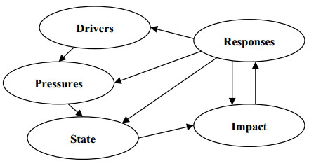
Spangenberg JH, Douguet J-M, Settele J, et al. (2015) Escaping the lock-in of continuous insecticide spraying in rice: Developing an integrated ecological and socio-political DPSIR analysis. Ecol Modell 295: 188–195. doi: 10.1016/j.ecolmodel.2014.05.010
![]() |
[49] | Smeets E, Weterings R (1999) Environmental indicators: Typology and overview. Copenhagen: European Environment Agency Press. |
[50] | Gabrielsen P, Bosch P (2003) Environmental indicators: Typology and overview. Copenhagen: European Environment Agency Intern. Work. Pap. |
[51] | European Environment Agency (2006) EEA Glossary. Brussels: European Commission. |
[52] | Voogd H (1983) Multicriteria evaluation for urban and regional planning. Delft: Delftsche Uitgevers Maatschappij B.V. |
[53] |
Carver SJ (1991) Integrating multi-criteria evaluation with geographical information systems. Int J Geogr Inf Syst 5: 321–339. doi: 10.1080/02693799108927858
![]() |
[54] | Eastman JR (2012) IDRISI Selva manual. Worcester, MA, USA: Clark University Press. |
[55] | Malczewski J (1999) GIS and multicriteria decision analysis. New York: John Wiley and Sons, Inc. |
[56] | Shahabi H, Niyazi C (2009) Effecting factors in relief and rescue stations site selection by using weighted linear combination, case study: Saghez-Sanandaj road. In: Proceedings of the Eighth International Conference on Geomatics. Tehran: ICG 2009. |
[57] | Burrough PA (1990) Methods of Spatial Analysis in GIS. Int J Geogr Inform Syst 4: 221–223. |
[58] | Saaty TL (2001) Fundamentals of the Analytic Hierarchy Process. Dordrecht: Springer, 15–35. |
[59] |
Deng H (1999) Multicriteria analysis with fuzzy pairwise comparison. Int J Approx Reason 21: 215–231. doi: 10.1016/S0888-613X(99)00025-0
![]() |
[60] |
Boroushaki S, Malczewski J (2008) Implementing an extension of the analytical hierarchy process using ordered weighted averaging operators with fuzzy quantifiers in ArcGIS. Comput Geosci 34: 399–410. doi: 10.1016/j.cageo.2007.04.003
![]() |
[61] |
Linkov I, Satterstrom FK, Steevens J, et al. (2007) Multi-criteria decision analysis and environmental risk assessment for nanomaterials. J Nanoparticle Res 9: 543–554. doi: 10.1007/s11051-007-9211-0
![]() |
[62] | Alam Tabriz A, Bagherzade Azar M (2009) Combining AHP and TOPSIS Adjusted for supplier selection strategy. Res Manag 6: 149–181. |
[63] | Ghodsi Poor H (2010) Analytical Hierarchy Process (AHP). Tehran: Amirkabir University of Technology Press. |
[64] | Razmi J, Sadegh Amal Nik M, Hashemi M (2008) Supplier selection techniques using fuzzy analytic network process. Tehran Uni Eng 42: 935–946. |
[65] |
Leung LC, Cao D (2000) On consistency and ranking of alternatives in fuzzy AHP. Eur J Oper Res 124: 102–113. doi: 10.1016/S0377-2217(99)00118-6
![]() |
[66] | Hansen HS (2005) GIS-based Multi-Criteria Analysis of Wind Farm Development. In: Hauska H, Tveite H, ScanGis 2005: Proceedings of the Tenth Scandinavian Research Conference on Geographical Information Science. Stockholm: Department of Planning and Environment, 75–87. |
[67] |
Lee S (2007) Application and verification of fuzzy algebraic operators to landslide susceptibility mapping. Environ Geol 52: 615–623. doi: 10.1007/s00254-006-0491-y
![]() |
[68] | Kabir S, Edifor E, Walker M, et al. (2014) Quantification of Temporal Fault Trees Based on Fuzzy Set Theory. Springer, Cham, pp 255–264 |
[69] | Ghosh JK, Bhattacharya D, Sharma SK (2012) Fuzzy Knowledge Based GIS for Zonation of Landslide Susceptibility. In: Zamojski W, Mazurkiewicz J, Sugier J, et al., Proceedings of the Ninth International Conference on Dependability and Complex Systems DepCoS-RELCOMEX. Brunów, Poland: Springer, Cham. |
[70] |
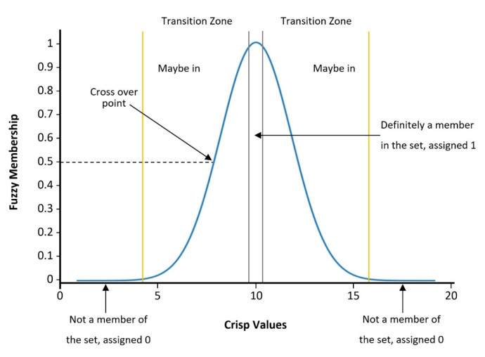
Dombi J (1990) Membership function as an evaluation. Fuzzy Sets Syst 35: 1–21. doi: 10.1016/0165-0114(90)90014-W
![]() |
[71] | Keller CP (1995) Geographic information systems for geoscientists: Modelling with GIS. Iny Graeme F. Bonham-Carter, Pergamon, Computer Methods in the Geosciences, Volume 13, 1994, 398 p., incl. bibliographic references and index, US $40.00. Comput Geosci 21: 1110–1112. |
[72] |
Zimmermann HJ, Zysno P (1980) Latent connectives in human decision making. Fuzzy Sets Syst 4: 37–51. doi: 10.1016/0165-0114(80)90062-7
![]() |
[73] |
Atkinson DM, Deadman P, Dudycha D, et al. (2005) Multi-criteria evaluation and least cost path analysis for an arctic all-weather road. Appl Geogr 25: 287–307. doi: 10.1016/j.apgeog.2005.08.001
![]() |
[74] | Salari M, Bagherpour M, Wang J (2014) A novel earned value management model using Z-number. Int J Appl Decis Sci 7: 97–119. |
[75] |
Önüt S, Kara SS, Işik E (2009) Long term supplier selection using a combined fuzzy MCDM approach: A case study for a telecommunication company. Expert Syst Appl 36: 3887–3895. doi: 10.1016/j.eswa.2008.02.045
![]() |
[76] |
Gogus O, Boucher TO (1998) Strong transitivity, rationality and weak monotonicity in fuzzy pairwise comparisons. Fuzzy Sets Syst 94: 133–144. doi: 10.1016/S0165-0114(96)00184-4
![]() |
[77] | Lin H, Kao J, Li K, et al. (1996) Fuzzy GIS assisted landfill siting analysis. In: Proceedings of the Twelfth International Conference on Solid Waste Technology and Management. Philadelphia, PA, USA: Journal of Solid Waste Technology and Management, 14–17. |
[78] | Valizadeh K, Shababi H (2009) Necessities of GIS usage in urban water management at the time of Natural accidents (Case Study: Saqqez City). In: Proceeding of the Fourth International Conference on Geographic Information Systems. Paris: ICGIS. |
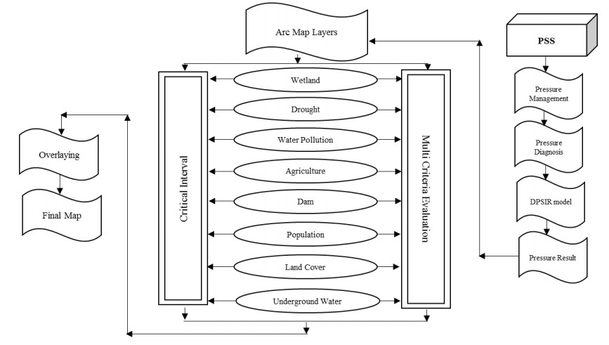
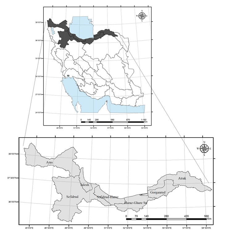
[79] | Ministry of Energy (2013) Water Master Plan Udate in the Aras, Urmia, Talesh, Sefidrud, Sefidrud-Haraz, Haraz-Ghareh Su, Gorganrud-Ghareh Su, Atrak. Ministry of Energy, Water and Abfa Deputy. Tehran: Office of Planning and Abfa Macro Water. |
[80] | Statistical Center of Iran (2012) Iran Census of Population and Housing, 2011. Tehran: SCI Press. |
1. | Juan M. Sánchez, Juan P. Rodríguez, Helbert E. Espitia, Review of Artificial Intelligence Applied in Decision-Making Processes in Agricultural Public Policy, 2020, 8, 2227-9717, 1374, 10.3390/pr8111374 | |
2. | Juan-Manuel Sánchez-Céspedes, Juan-Pablo Rodríguez-Miranda, Octavio-José Salcedo-Parra, Aplicación de la inteligencia artificial en la formulación de políticas públicas relacionadas con la vocación agrícola de las regiones, 2022, 44, 2344-8350, 172, 10.14483/23448350.18576 | |
3. | Juan M. Sánchez, Juan P. Rodríguez, Helbert E. Espitia, Bibliometric analysis of publications discussing the use of the artificial intelligence technique agent-based models in sustainable agriculture, 2022, 8, 24058440, e12005, 10.1016/j.heliyon.2022.e12005 | |
4. | Xinru Xiao, Yue Su, Application of water resource economic management model in agricultural structure adjustment, 2023, 23, 1606-9749, 3832, 10.2166/ws.2023.233 |
Criteria | Final fuzzy weight of Criteria | Final weight of Criteria |
Non-human | (0.172, 0.182, 0.223) | 0.193 |
Human | (0.668, 0.818, 0.862) | 0.807 |
Sub-criteria | Final fuzzy weight of Sub-criteria | Final weight of Sub-criteria |
Degradation of wetland | (0.039, 0.05, 0.077) | 0.053 |
Drought | (0.099, 0.149, 0.194) | 0.149 |
Water pollution | (0.113, 0.174, 0.234) | 0.175 |
Agricultural water use | (0.147, 0.252, 0.308) | 0.243 |
Dam building | (0.027, 0.038, 0.05) | 0.039 |
Population density | (0.042, 0.068, 0.091) | 0.069 |
Land cover changes | (0.059, 0.087, 0.123) | 0.089 |
Groundwater use | (0.111, 0.184, 0.243) | 0.183 |
Forms of fuzzy functions | Fuzzy function |
Increasing sigmoidal | ![]() |
Decreasing Sigmoidal | ![]() |
Sub-basin | Groundwater use1 | Land cover changes2 | Population density3 | Dam building4 | Agricultural water use5 | Water pollution6 | Drought7 | Changes in the wetland8 |
Aras | 8.8 | 12.86 | 55.2 | 4.14 | 1.24 | 6.7 | 0.1765 | 0.11 |
Talesh | 0 | 28.91 | 126.1 | 4.22 | 0.44 | 69.3 | 0.0018 | 0.82 |
Sefidrud | 11.3 | 8.18 | 45.9 | 66.9 | 0.79 | 17 | 0.0037 | 9.94 |
Sefirud-Haraz | 8.9 | 21.11 | 101.1 | 5.69 | 0.99 | 51.3 | -0.013 | 6.2 |
Haraz-Ghareh Su | 33.5 | 19.44 | 135.1 | 47.83 | 1.15 | 41.3 | -0.006 | 0.49 |
Gorganrud-Ghareh Su | 35 | 18.9 | 66.9 | 51.81 | 1.65 | 0 | -1.12 | 0.1 |
Atrak | 9 | 14.09 | 38.6 | 19.09 | 0.91 | 0 | -0.026 | 0.21 |
Note: 1 Ratio of forbidden plains area to sub-basins area (percentage). 2 Ratio of changes in land covers area (between 2001–2012) to sub-basins area (percentage). 3 2011 population density of sub-basins (number of people per square kilometer). 4 Ratio of accumulated water behind the dam to surface water (percentage). 5 Water efficiency in agricultural production (kg production/ m3 water). 6 Average percentage of high pollution area by N, P, BOD (percentage). 7 DIP indicator. 8 Ratio of wetlands area in the 2012 to base level. |
Criteria | Sub-criteria | Fuzzy function | Control points | |||
A | B | C | D | |||
Non-human | Changes in the wetland | Increasing sigmoidal | 0.5 | 1 | 1 | 1 |
Drought | Increasing sigmoidal | 2 | -2 | -2 | -2 | |
Human | Water pollution | Decreasing sigmoidal | 5 | 5 | 5 | 50 |
Agricultural water use | Increasing sigmoidal | 0.5 | 2.5 | 2.5 | 2.5 | |
Dam building | Decreasing sigmoidal | 10 | 10 | 10 | 40 | |
Population density | Decreasing sigmoidal | 20 | 20 | 20 | 160 | |
Land cover changes | Decreasing sigmoidal | 1 | 1 | 1 | 0 | |
Groundwater use | Decreasing sigmoidal | 5 | 5 | 5 | 40 | |
Source: Authors' own elaboration. Note: data is obtained from Water Master-plan Update and Statistical Yearbook of Water [79] case-studying: drought, water pollution, agricultural water use, dam building, and groundwater use. In addition, information about population is based on the Census of Population and Housing, 2011 [80]. Wetlands and land cover changes data are obtained using remote-sensing techniques and MODIS satellite images between 2001 and 2012. |